
Elmira Poor Armstrong
| Birth | : | 11 Nov 1833 McLean County, Illinois, USA |
| Death | : | 23 Jan 1916 Holton, Jackson County, Kansas, USA |
| Burial | : | Onida Cemetery, Onida, Sully County, USA |
| Coordinate | : | 44.7147000, -100.0650000 |
| Plot | : | Section 4 (west), Lot 7, Block 110 |
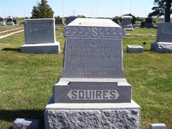
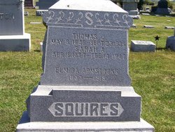
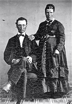
| Description | : | The Holton Recorder, January 27, 1916: Elmira Poor was born near Bloomington, McLean county, Illinois, Nov. 11, 1833, and departed this life in Holton, Kan., Jan. 23, 1916, aged 82 years, 2 months and 12 days. She was united in marriage to Peter Armstrong on March 20, 1850. To this union were born 7 children; 4 died in infancy. Only two survive at this time, Mrs. T. J. Squires of Holton and Chas. Armstrong of near Holton. Father Armstrong died in Springfield, Mo., Nov. 27, 1862. He was a member of Co. B, 9th Ill. Infantry. Mother Armstrong made her home... Read More |
frequently asked questions (FAQ):
-
Where is Elmira Poor Armstrong's memorial?
Elmira Poor Armstrong's memorial is located at: Onida Cemetery, Onida, Sully County, USA.
-
When did Elmira Poor Armstrong death?
Elmira Poor Armstrong death on 23 Jan 1916 in Holton, Jackson County, Kansas, USA
-
Where are the coordinates of the Elmira Poor Armstrong's memorial?
Latitude: 44.7147000
Longitude: -100.0650000
Family Members:
Spouse
Children
Flowers:


Nearby Cemetories:
1. Onida Cemetery
Onida, Sully County, USA
Coordinate: 44.7147000, -100.0650000
2. Holy Rosary Cemetery
Agar, Sully County, USA
Coordinate: 44.8380000, -100.0616000
3. Schreiber Cemetery
Agar, Sully County, USA
Coordinate: 44.8821983, -100.1196976
4. Pleasant Hill Cemetery
Blunt, Hughes County, USA
Coordinate: 44.5135994, -100.0156021
5. Pleasant Cemetery
Sully County, USA
Coordinate: 44.6927986, -99.7568970
6. Okobojo Cemetery
Sully County, USA
Coordinate: 44.6568985, -100.3647003
7. Byron Township Cemetery
Blunt, Hughes County, USA
Coordinate: 44.4979200, -100.1904700
8. Blair Cemetery
Sully County, USA
Coordinate: 44.8027992, -100.4199982
9. Petro Family Cemetery
Gettysburg, Potter County, USA
Coordinate: 44.9706825, -100.2259903
10. Sacred Heart Cemetery
Gettysburg, Potter County, USA
Coordinate: 44.9982986, -99.9377975
11. Medicine Hill Cemetery
Harrold, Hughes County, USA
Coordinate: 44.5116997, -99.7453003
12. Copp Cemetery
Potter County, USA
Coordinate: 44.9118935, -99.7358236
13. Saint John Catholic Cemetery
Harrold, Hughes County, USA
Coordinate: 44.5127983, -99.7335968
14. Gettysburg Memorial Cemetery
Gettysburg Township, Potter County, USA
Coordinate: 45.0208146, -99.9898400
15. Canning Cemetery
Hughes County, USA
Coordinate: 44.3986890, -100.0278460
16. Gettysburg Cemetery
Gettysburg, Potter County, USA
Coordinate: 45.0149994, -99.9199982
17. Forest City Cemetery (Defunct)
Forest City, Potter County, USA
Coordinate: 45.0239900, -100.2667000
18. Mount Calvary Cemetery
Pierre, Hughes County, USA
Coordinate: 44.4197006, -100.3557968
19. Spring Lake Cemetery
Hyde County, USA
Coordinate: 44.7942009, -99.5610962
20. Riverside Cemetery
Pierre, Hughes County, USA
Coordinate: 44.3608017, -100.3071976
21. Scotty Philip Cemetery
Fort Pierre, Stanley County, USA
Coordinate: 44.4019012, -100.4036026
22. Fort Pierre Chouteau Cemetery
Fort Pierre, Stanley County, USA
Coordinate: 44.3908700, -100.3878300
23. South Dakota State Capitol Grounds
Pierre, Hughes County, USA
Coordinate: 44.3660100, -100.3448000
24. Lebanon Cemetery
Lebanon, Potter County, USA
Coordinate: 45.0635500, -99.7768400