
| Memorials | : | 0 |
| Location | : | Hughes County, USA |
| Coordinate | : | 44.3986890, -100.0278460 |
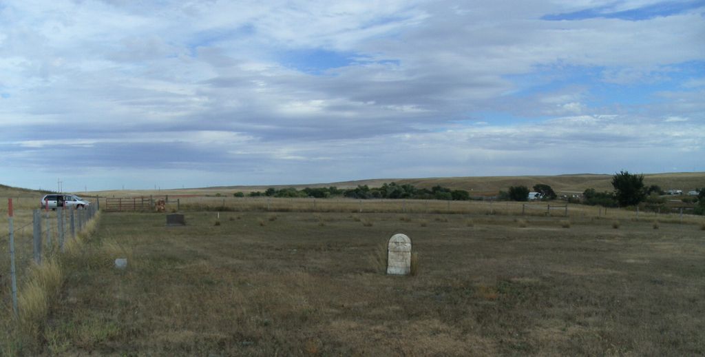
| Description | : | This cemetery is located at the east end of what's left of the town of Canning, off the end of Cactus Loop Rd, north of the railroad tracks in a fenced field. Access is east off of Spring/Cactus Loop, down a slight grade, across a narrow bridge over a drainage, back up to an unlocked gate (please close behind you) and then continue east until another fence-line and turn south for a bit. An unlocked gate to the cemetery allows access. There are only about a dozen visible markers in this graveyard, most without inscription. This... Read More |
frequently asked questions (FAQ):
-
Where is Canning Cemetery?
Canning Cemetery is located at Hughes County ,South Dakota ,USA.
-
Canning Cemetery cemetery's updated grave count on graveviews.com?
0 memorials
-
Where are the coordinates of the Canning Cemetery?
Latitude: 44.3986890
Longitude: -100.0278460
Nearby Cemetories:
1. Pleasant Hill Cemetery
Blunt, Hughes County, USA
Coordinate: 44.5135994, -100.0156021
2. Holy Name Episcopal Cemetery
Fort Pierre, Stanley County, USA
Coordinate: 44.2694960, -100.0357300
3. Holy Name Chapel Cemetery
Fort Pierre, Stanley County, USA
Coordinate: 44.2694292, -100.0356989
4. Chapelle Cemetery
Hughes County, USA
Coordinate: 44.3025017, -99.8653030
5. Byron Township Cemetery
Blunt, Hughes County, USA
Coordinate: 44.4979200, -100.1904700
6. Riverside Cemetery
Pierre, Hughes County, USA
Coordinate: 44.3608017, -100.3071976
7. South Dakota State Capitol Grounds
Pierre, Hughes County, USA
Coordinate: 44.3660100, -100.3448000
8. Medicine Hill Cemetery
Harrold, Hughes County, USA
Coordinate: 44.5116997, -99.7453003
9. Mount Calvary Cemetery
Pierre, Hughes County, USA
Coordinate: 44.4197006, -100.3557968
10. Saint John Catholic Cemetery
Harrold, Hughes County, USA
Coordinate: 44.5127983, -99.7335968
11. Saint Catherines Cemetery
Harrold, Hughes County, USA
Coordinate: 44.2091100, -99.7868200
12. Fort Pierre Chouteau Cemetery
Fort Pierre, Stanley County, USA
Coordinate: 44.3908700, -100.3878300
13. Holy Faith Cemetery
Lyman County, USA
Coordinate: 44.1356010, -99.9878006
14. Scotty Philip Cemetery
Fort Pierre, Stanley County, USA
Coordinate: 44.4019012, -100.4036026
15. Cedar Hill Cemetery
Fort Pierre, Stanley County, USA
Coordinate: 44.3356018, -100.3964005
16. Ascension Cemetery
Canning, Hughes County, USA
Coordinate: 44.1523700, -99.7927100
17. Onida Cemetery
Onida, Sully County, USA
Coordinate: 44.7147000, -100.0650000
18. Pleasant Cemetery
Sully County, USA
Coordinate: 44.6927986, -99.7568970
19. Okobojo Cemetery
Sully County, USA
Coordinate: 44.6568985, -100.3647003
20. Messiah Episcopal Cemetery
Lower Brule, Lyman County, USA
Coordinate: 44.1011800, -99.7380800
21. Immaculate Conception Mission Cemetery
Stephan, Hyde County, USA
Coordinate: 44.2447100, -99.4566500
22. Mathews Family Cemetery
Stanley County, USA
Coordinate: 44.1816040, -100.5581080
23. Holy Rosary Cemetery
Agar, Sully County, USA
Coordinate: 44.8380000, -100.0616000
24. Saint Marys Catholic Cemetery
Highmore, Hyde County, USA
Coordinate: 44.5063800, -99.4214900