
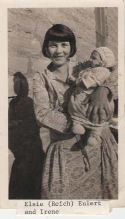


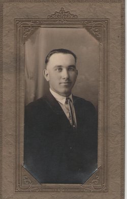
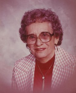
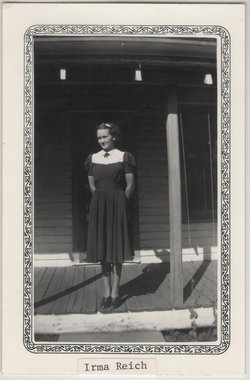
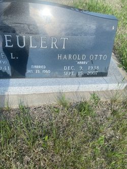
Elsie Helen Reich Eulert
| Birth | : | 27 Mar 1906 Yale, Beadle County, South Dakota, USA |
| Death | : | 5 Feb 2001 Russell, Russell County, Kansas, USA |
| Burial | : | Natoma Lutheran Cemetery, Natoma, Osborne County, USA |
| Coordinate | : | 39.1907700, -99.0162700 |
| Description | : | Elsie H. Eulert, 94, died Monday, Feb. 5, 2001, at Main Street Manor, Russell. She was born March 27, 1906, in Yale, S.D., to Jacob and Ida (Kuehl) Reich. She came to Kansas in her teen years, receiving her education in the Natoma schools. She married Otto C. Eulert on Dec. 17, 1925, in WaKeeney. He died March 5, 1983. She lived on Eulert Ranch in the Fairport area. She was a homemaker and farmed with her husband. She was a member of the Peace Lutheran Church, Natoma, and the Ladies Guild of the church. She moved to Main... Read More |
frequently asked questions (FAQ):
-
Where is Elsie Helen Reich Eulert's memorial?
Elsie Helen Reich Eulert's memorial is located at: Natoma Lutheran Cemetery, Natoma, Osborne County, USA.
-
When did Elsie Helen Reich Eulert death?
Elsie Helen Reich Eulert death on 5 Feb 2001 in Russell, Russell County, Kansas, USA
-
Where are the coordinates of the Elsie Helen Reich Eulert's memorial?
Latitude: 39.1907700
Longitude: -99.0162700
Family Members:
Parent
Spouse
Siblings


Children
Flowers:


Nearby Cemetories:
1. Natoma Cemetery
Natoma, Osborne County, USA
Coordinate: 39.1907700, -99.0162700
2. Natoma Lutheran Cemetery
Natoma, Osborne County, USA
Coordinate: 39.1907700, -99.0162700
3. Natoma Catholic Cemetery
Natoma, Osborne County, USA
Coordinate: 39.2054050, -99.0289480
4. Immanuel Lutheran Cemetery
Natoma, Osborne County, USA
Coordinate: 39.2708015, -99.0096970
5. Mount Hermon Cemetery
Paradise, Russell County, USA
Coordinate: 39.1324997, -98.9439011
6. Bowlby Ranch Cemetery
Ellis County, USA
Coordinate: 39.1127430, -99.0513540
7. Round Mound Cemetery
Osborne County, USA
Coordinate: 39.2630997, -98.9636002
8. Conger Cemetery
Plainville, Rooks County, USA
Coordinate: 39.1978700, -99.1232100
9. IXL Cemetery
Natoma, Osborne County, USA
Coordinate: 39.2491989, -98.9218979
10. Aurora Cemetery
Laton, Rooks County, USA
Coordinate: 39.2778015, -99.0847015
11. Shiloh Cemetery
Codell, Rooks County, USA
Coordinate: 39.2350006, -99.1410980
12. Victor Cemetery
Osborne County, USA
Coordinate: 39.2380981, -98.8613968
13. Norman Cemetery
Ellis County, USA
Coordinate: 39.1044006, -99.1575012
14. Chalk Mound Cemetery
Laton, Rooks County, USA
Coordinate: 39.3208008, -99.0852966
15. Fairport Cemetery
Russell County, USA
Coordinate: 39.0463982, -99.0207977
16. Cedar Bluff Cemetery
Osborne County, USA
Coordinate: 39.2496986, -98.8431015
17. Pleasant Plain Cemetery
Osborne County, USA
Coordinate: 39.3367004, -99.0372009
18. Paradise Center Cemetery
Codell, Rooks County, USA
Coordinate: 39.2050570, -99.2058100
19. Cole Cemetery
Osborne County, USA
Coordinate: 39.2352982, -98.8060989
20. Waldo Catholic Cemetery
Waldo Township, Russell County, USA
Coordinate: 39.1036600, -98.8162400
21. Covert Cemetery
Osborne County, USA
Coordinate: 39.2896996, -98.8107986
22. Mount Ayr Cemetery
Alton, Osborne County, USA
Coordinate: 39.3764000, -98.9717026
23. Twin Mound Cemetery
Rooks County, USA
Coordinate: 39.2855988, -99.2319031
24. Survey Cemetery
Woodston, Rooks County, USA
Coordinate: 39.3722000, -99.1333008