
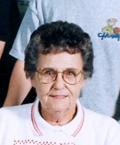
| Birth | : | 26 Apr 1937 Strauss, Labette County, Kansas, USA |
| Death | : | 19 Jun 2018 Frontenac, Crawford County, Kansas, USA |
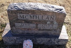
| Burial | : | Glenwood Cemetery, Glen Elder, Mitchell County, USA |
| Coordinate | : | 39.5052986, -98.2818985 |
| Description | : | Elsie was married first to Clayton Arthur Long May 30, 1954. After Clayton passed away she was married again to J C Braman October 1, 2000. Information shared by Elkco - Thank you |
frequently asked questions (FAQ):
-
Where is Elsie Maxine McMillan Long-Braman's memorial?
Elsie Maxine McMillan Long-Braman's memorial is located at: Glenwood Cemetery, Glen Elder, Mitchell County, USA.
-
When did Elsie Maxine McMillan Long-Braman death?
Elsie Maxine McMillan Long-Braman death on 19 Jun 2018 in Frontenac, Crawford County, Kansas, USA
-
Where are the coordinates of the Elsie Maxine McMillan Long-Braman's memorial?
Latitude: 39.5052986
Longitude: -98.2818985
Family Members:
Parent

Spouse
Siblings

Flowers:


Nearby Cemetories:
1. Glenwood Cemetery
Glen Elder, Mitchell County, USA
Coordinate: 39.5052986, -98.2818985
2. Glen Elder Pioneer Cemetery
Glen Elder, Mitchell County, USA
Coordinate: 39.5020550, -98.3105670
3. Fairview Cemetery South
Glen Elder, Mitchell County, USA
Coordinate: 39.4667015, -98.3063965
4. Browns Creek Cemetery
Solomon Rapids, Mitchell County, USA
Coordinate: 39.5393982, -98.2463989
5. Grellett Cemetery
Glen Elder, Mitchell County, USA
Coordinate: 39.4813995, -98.3506012
6. Granite Creek Cemetery (Defunct)
Cawker City, Mitchell County, USA
Coordinate: 39.5097008, -98.3760986
7. Honey Creek Cemetery
Solomon Rapids, Mitchell County, USA
Coordinate: 39.4328003, -98.2517014
8. Walnut Creek Cemetery
Walnut Creek Township, Mitchell County, USA
Coordinate: 39.4522018, -98.3625031
9. Glendale Cemetery
Solomon Rapids, Mitchell County, USA
Coordinate: 39.5537300, -98.1813000
10. Pleasant Valley Cemetery
Beloit, Mitchell County, USA
Coordinate: 39.4555900, -98.1722200
11. Athens Cemetery
Jewell, Jewell County, USA
Coordinate: 39.6105995, -98.3024979
12. Naomi Cemetery
Walnut Creek Township, Mitchell County, USA
Coordinate: 39.4156036, -98.3588257
13. Prairie Grove Cemetery
Cawker City, Mitchell County, USA
Coordinate: 39.5243988, -98.4257965
14. High Prairie Cemetery
Glen Elder, Mitchell County, USA
Coordinate: 39.3933300, -98.3113890
15. Saints Peter and Paul Cemetery
Cawker City, Mitchell County, USA
Coordinate: 39.5248130, -98.4282290
16. Atkins Union Cemetery
Jewell, Jewell County, USA
Coordinate: 39.5956000, -98.1733000
17. Excelsior Cemetery
Walnut Creek Township, Mitchell County, USA
Coordinate: 39.3967018, -98.3578033
18. Sample Cemetery
Ionia, Jewell County, USA
Coordinate: 39.6033250, -98.3923710
19. Beloit Industrial School Cemetery
Beloit, Mitchell County, USA
Coordinate: 39.4755000, -98.1105810
20. Hopewell Cemetery
Beloit, Mitchell County, USA
Coordinate: 39.3800011, -98.2097015
21. Star Cemetery
Jewell, Jewell County, USA
Coordinate: 39.5882500, -98.1379400
22. Elmwood Cemetery
Beloit, Mitchell County, USA
Coordinate: 39.4693985, -98.1014023
23. Saint Johns Cemetery
Beloit, Mitchell County, USA
Coordinate: 39.4667015, -98.1018982
24. Couch Cemetery
Jewell, Jewell County, USA
Coordinate: 39.6401100, -98.2134094