
| Birth | : | 8 Apr 1928 Davis County, Iowa, USA |
| Death | : | 16 Feb 1965 Sioux City, Woodbury County, Iowa, USA |
| Burial | : | Evergreen Memorial Park Cemetery, Omaha, Douglas County, USA |
| Coordinate | : | 41.2393990, -96.0355988 |
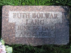
| Description | : | S/O Wilbur L. & Ruth A. Bolwar Lang He never married 1965 - Lang Services (Newspaper clipping - 1965) Funeral services for Elwood Eugene Lang, 37, of South Sioux City, Neb., a former Ottumwan, will be held in South Sioux City with burial in Omaha. Lang died instantly Tuesday at 1:30 a.m., when his car left the highway at a bridge approach near South Sioux City and struck a tree. He was the son of Wilbur and Ruth Bolwar Lang, and was born near Ottumwa on April 7, 1928. He graduated from Ottumwa High School in 1946, served two years in military service, then... Read More |
frequently asked questions (FAQ):
-
Where is Elwood Eugene Lang's memorial?
Elwood Eugene Lang's memorial is located at: Evergreen Memorial Park Cemetery, Omaha, Douglas County, USA.
-
When did Elwood Eugene Lang death?
Elwood Eugene Lang death on 16 Feb 1965 in Sioux City, Woodbury County, Iowa, USA
-
Where are the coordinates of the Elwood Eugene Lang's memorial?
Latitude: 41.2393990
Longitude: -96.0355988
Family Members:
Parent

Flowers:


Nearby Cemetories:
1. Evergreen Memorial Park Cemetery
Omaha, Douglas County, USA
Coordinate: 41.2393990, -96.0355988
2. Resurrection Cemetery
Omaha, Douglas County, USA
Coordinate: 41.2344208, -96.0365448
3. Calvary Cemetery
Omaha, Douglas County, USA
Coordinate: 41.2364006, -96.0294037
4. Saint Andrews Episcopal Church Columbarium
Omaha, Douglas County, USA
Coordinate: 41.2492500, -96.0427500
5. Countryside Community Church Columbarium
Omaha, Douglas County, USA
Coordinate: 41.2483660, -96.0500270
6. Ak-Sar-Ben Racetrack Grounds
Omaha, Douglas County, USA
Coordinate: 41.2414703, -96.0159607
7. Beth El Cemetery
Ralston, Douglas County, USA
Coordinate: 41.2117004, -96.0428009
8. Westlawn-Hillcrest Memorial Park
Omaha, Douglas County, USA
Coordinate: 41.2346992, -95.9966965
9. Bohemian Cemetery
Omaha, Douglas County, USA
Coordinate: 41.2388992, -95.9955978
10. Holy Sepulchre Cemetery
Omaha, Douglas County, USA
Coordinate: 41.2543983, -95.9875031
11. All Saints Episcopal Church Columbarium
Omaha, Douglas County, USA
Coordinate: 41.2785000, -96.0579000
12. Douglas County Poor Farm Cemetery
Omaha, Douglas County, USA
Coordinate: 41.2437240, -95.9723480
13. Graceland Park Cemetery
Omaha, Douglas County, USA
Coordinate: 41.2113991, -95.9785995
14. Saint Mary Magdalene Cemetery
Omaha, Douglas County, USA
Coordinate: 41.2039420, -95.9850610
15. Nash Chapel Crypt
Omaha, Douglas County, USA
Coordinate: 41.2665090, -95.9721790
16. First Central Congregational Columbarium
Omaha, Douglas County, USA
Coordinate: 41.2563456, -95.9658365
17. Servants of Mary Cemetery
Omaha, Douglas County, USA
Coordinate: 41.3017170, -96.0258260
18. Papillion Cemetery
Papillion, Sarpy County, USA
Coordinate: 41.1758003, -96.0410995
19. Saint Mary's Cemetery
Omaha, Douglas County, USA
Coordinate: 41.2042007, -95.9646988
20. Mount Hope Cemetery
Omaha, Douglas County, USA
Coordinate: 41.3041992, -96.0310974
21. Portal Cemetery
Sarpy County, USA
Coordinate: 41.1838989, -96.0802994
22. Pleasant Hill Cemetery
Omaha, Douglas County, USA
Coordinate: 41.2558975, -96.1194687
23. Prospect Hill Cemetery
Omaha, Douglas County, USA
Coordinate: 41.2780991, -95.9593964
24. Mount Sinai Cemetery
Omaha, Douglas County, USA
Coordinate: 41.3116989, -96.0314026