

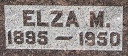
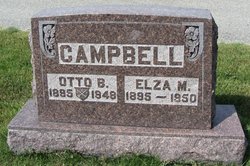
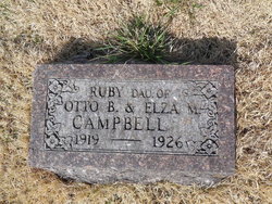
Elza M “Elzie” Roark Campbell
| Birth | : | 10 May 1895 |
| Death | : | 24 Jun 1950 |
| Burial | : | St Margaret Churchyard, Hales, South Norfolk District, England |
| Coordinate | : | 52.5109380, 1.5110840 |
| Plot | : | Section 2 |
frequently asked questions (FAQ):
-
Where is Elza M “Elzie” Roark Campbell's memorial?
Elza M “Elzie” Roark Campbell's memorial is located at: St Margaret Churchyard, Hales, South Norfolk District, England.
-
When did Elza M “Elzie” Roark Campbell death?
Elza M “Elzie” Roark Campbell death on 24 Jun 1950 in
-
Where are the coordinates of the Elza M “Elzie” Roark Campbell's memorial?
Latitude: 52.5109380
Longitude: 1.5110840
Family Members:
Parent

Spouse
Siblings
Children


Nearby Cemetories:
1. St Margaret Churchyard
Hales, South Norfolk District, England
Coordinate: 52.5109380, 1.5110840
2. St Andrews Churchyard
Raveningham, South Norfolk District, England
Coordinate: 52.5126430, 1.5323570
3. All Saints Churchyard
Kirby Cane, South Norfolk District, England
Coordinate: 52.4937500, 1.4952820
4. St Gregory Churchyard
Heckingham, South Norfolk District, England
Coordinate: 52.5350940, 1.5144710
5. Holy Trinity Churchyard
Loddon, South Norfolk District, England
Coordinate: 52.5350430, 1.4832560
6. Ss Mary and Margaret Churchyard
Norton Subcourse, North Norfolk District, England
Coordinate: 52.5324780, 1.5483860
7. Methodist Churchyard
Norton Subcourse, North Norfolk District, England
Coordinate: 52.5317630, 1.5557020
8. All Saints Churchyard
Chedgrave, South Norfolk District, England
Coordinate: 52.5409130, 1.4831200
9. St Michael Churchyard
Geldeston, South Norfolk District, England
Coordinate: 52.4759460, 1.5246070
10. St Mary's Churchyard
Ellingham, South Norfolk District, England
Coordinate: 52.4739393, 1.4827976
11. St Margaret's Churchyard
Hardley Street, South Norfolk District, England
Coordinate: 52.5522980, 1.5170630
12. All Saints Churchyard
Gillingham, South Norfolk District, England
Coordinate: 52.4753720, 1.5479546
13. St Michael's Churchyard
Broome, South Norfolk District, England
Coordinate: 52.4860360, 1.4547410
14. St Mary's Churchyard
Gillingham, South Norfolk District, England
Coordinate: 52.4750343, 1.5489500
15. Hardley Methodist Chapel
Langley with Hardley, South Norfolk District, England
Coordinate: 52.5577290, 1.4957960
16. St. Michaels's Church Cemetery
Langley with Hardley, South Norfolk District, England
Coordinate: 52.5552220, 1.4727530
17. Thorpe-next-Haddiscoe St Mathias Churchyard
Haddiscoe, South Norfolk District, England
Coordinate: 52.5261880, 1.5896380
18. St. Mary's Churchyard
Haddiscoe, South Norfolk District, England
Coordinate: 52.5153200, 1.5939300
19. St Peter's Churchyard
Mundham, South Norfolk District, England
Coordinate: 52.5303890, 1.4260120
20. St. Bartholomew's Churchyard
Shipmeadow, Waveney District, England
Coordinate: 52.4557540, 1.5046408
21. Wangford Union Workhouse Cemetery
Shipmeadow, Waveney District, England
Coordinate: 52.4540960, 1.4997050
22. All Saints Churchyard
Mettingham, Waveney District, England
Coordinate: 52.4566620, 1.4764720
23. Ditchingham Cemetery
Ditchingham, South Norfolk District, England
Coordinate: 52.4793614, 1.4307304
24. St Margaret and St Remigius Churchyard
Seething, South Norfolk District, England
Coordinate: 52.5303390, 1.4185000