
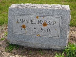
Emanuel Narber
| Birth | : | 24 Mar 1855 Stephenson County, Illinois, USA |
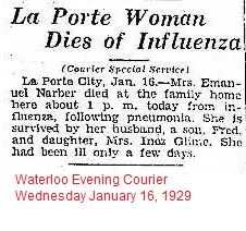
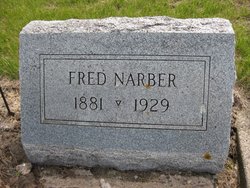
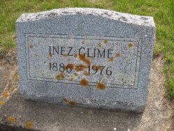
| Death | : | 22 Mar 1940 La Porte City, Black Hawk County, Iowa, USA |
| Burial | : | Westview Cemetery, La Porte City, Black Hawk County, USA |
| Coordinate | : | 42.3107986, -92.1699982 |
| Plot | : | Block 6 |
| Description | : | The 1878 History of Benton County, Iowa Narber, Emanuel, farmer, Sec. 6; P. O. La Porte City; born in Stephenson Co. Ill., in 1855; removed to Benton Co. in 1857; has 280 acres of land, valued at $40 per acre. Democratic in politics. (1878 Bruce Township) Contributed by #70080311 |
frequently asked questions (FAQ):
-
Where is Emanuel Narber's memorial?
Emanuel Narber's memorial is located at: Westview Cemetery, La Porte City, Black Hawk County, USA.
-
When did Emanuel Narber death?
Emanuel Narber death on 22 Mar 1940 in La Porte City, Black Hawk County, Iowa, USA
-
Where are the coordinates of the Emanuel Narber's memorial?
Latitude: 42.3107986
Longitude: -92.1699982
Family Members:
Parent
Spouse
Siblings
Children
Flowers:


Nearby Cemetories:
1. Westview Cemetery
La Porte City, Black Hawk County, USA
Coordinate: 42.3107986, -92.1699982
2. Sawyer Cemetery
La Porte City, Black Hawk County, USA
Coordinate: 42.3381004, -92.1519012
3. Engledow Cemetery
Mount Auburn, Benton County, USA
Coordinate: 42.2686996, -92.1330032
4. Anton Cemetery
La Porte City, Black Hawk County, USA
Coordinate: 42.3418999, -92.2399979
5. Mount Auburn Cemetery
Mount Auburn, Benton County, USA
Coordinate: 42.2536800, -92.0903000
6. Spring Creek Chapel Cemetery
La Porte City, Black Hawk County, USA
Coordinate: 42.3616982, -92.0783005
7. Zion Lutheran Jubilee Cemetery
Jubilee, Black Hawk County, USA
Coordinate: 42.3843050, -92.0837440
8. Greenwalt Cemetery
Mount Auburn, Benton County, USA
Coordinate: 42.2256012, -92.1038971
9. Fairview Cemetery
Benton County, USA
Coordinate: 42.2141991, -92.2007980
10. Pratt Creek Cemetery
Vinton, Benton County, USA
Coordinate: 42.2104000, -92.1307400
11. Sancta Maria Cemetery
Gilbertville, Black Hawk County, USA
Coordinate: 42.4132560, -92.2060940
12. Shady Grove Cemetery
Jesup, Buchanan County, USA
Coordinate: 42.3805453, -92.0557342
13. Saint Mary's Cemetery
Gilbertville, Black Hawk County, USA
Coordinate: 42.4188300, -92.2181200
14. Hill Cemetery
Tama County, USA
Coordinate: 42.2542000, -92.3075027
15. Saint Marys of Mount Carmel Cemetery
Waterloo, Black Hawk County, USA
Coordinate: 42.3418000, -92.3280000
16. Brown Bruce Township Cemetery
Benton County, USA
Coordinate: 42.2163430, -92.2799680
17. Washburn Cemetery
Washburn, Black Hawk County, USA
Coordinate: 42.4139200, -92.2711700
18. Brandon Cemetery
Brandon, Buchanan County, USA
Coordinate: 42.3156300, -91.9945200
19. Jefferson Township Cemetery
Brandon, Buchanan County, USA
Coordinate: 42.3139000, -91.9931030
20. Beachler Cemetery
Brandon, Buchanan County, USA
Coordinate: 42.3045000, -91.9908000
21. Spencer Cemetery
Dysart, Tama County, USA
Coordinate: 42.2592120, -92.3353840
22. Eagle Township Cemetery
Black Hawk County, USA
Coordinate: 42.3410988, -92.3525009
23. Geneseo Cemetery
Buckingham, Tama County, USA
Coordinate: 42.2764370, -92.3523950
24. Carlisle Grove Cemetery
Garrison, Benton County, USA
Coordinate: 42.1730995, -92.1386032