
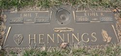
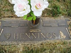
Emil Hennings
| Birth | : | 30 Jul 1909 O'Brien County, Iowa, USA |
| Death | : | 28 Mar 1993 Spencer, Clay County, Iowa, USA |
| Burial | : | North Lawn Cemetery, Spencer, Clay County, USA |
| Coordinate | : | 43.1600000, -95.1470000 |
| Description | : | Funeral services for Emil Hennings of Spencer were held at 10 a.m. Wednesday, March 31,1993, at Baumgarten Funeral Chapel in Spencer. Rev. Timothy Schott officiated. Casket bearers were Ron Hennings, Dave Hennings, Randy Franker, Jerry Lowe, Darrel Browner and Willie Hebbel. Burial was in Northlawn Cemetery of Spencer. The son of Adolph and Riga Scholish Hennings, Emil Theodore Hennings was bom July 30,1909, in O'Brien County, Iowa. He attended rural schools near his childhood home and high school through the ninth grade. On January 8, 1930, he married Ethel Rosa Franker at Spencer. They lived at Moneta until... Read More |
frequently asked questions (FAQ):
-
Where is Emil Hennings's memorial?
Emil Hennings's memorial is located at: North Lawn Cemetery, Spencer, Clay County, USA.
-
When did Emil Hennings death?
Emil Hennings death on 28 Mar 1993 in Spencer, Clay County, Iowa, USA
-
Where are the coordinates of the Emil Hennings's memorial?
Latitude: 43.1600000
Longitude: -95.1470000
Family Members:
Parent
Spouse

Siblings

Children
Flowers:


Nearby Cemetories:
1. North Lawn Cemetery
Spencer, Clay County, USA
Coordinate: 43.1600000, -95.1470000
2. Dewey Readmore Books Memorial
Spencer, Clay County, USA
Coordinate: 43.1403999, -95.1443024
3. Riverside Cemetery
Spencer, Clay County, USA
Coordinate: 43.1441994, -95.1671982
4. Fairview Cemetery
Clay County, USA
Coordinate: 43.1899986, -95.0800018
5. Evergreen Cemetery
Clay County, USA
Coordinate: 43.2052994, -95.2086029
6. Dickens Cemetery
Dickens, Clay County, USA
Coordinate: 43.1280000, -95.0155000
7. Swedish Lutheran Cemetery
Royal, Clay County, USA
Coordinate: 43.0683000, -95.2350000
8. Little Sioux Lutheran Cemetery
Milford, Dickinson County, USA
Coordinate: 43.2702065, -95.2109528
9. Rosehill Cemetery
Clay County, USA
Coordinate: 43.0368996, -95.0919037
10. First Reformed Cemetery
Clay County, USA
Coordinate: 43.2399500, -95.2889000
11. Lone Tree Cemetery
Everly, Clay County, USA
Coordinate: 43.1411018, -95.3347015
12. Milford Cemetery
Milford, Dickinson County, USA
Coordinate: 43.3092003, -95.1481018
13. Lincoln Cemetery
Rossie, Clay County, USA
Coordinate: 43.0111008, -95.2313995
14. Calvary Cemetery
Milford, Dickinson County, USA
Coordinate: 43.3213997, -95.1688995
15. Logan Township Cemetery
Clay County, USA
Coordinate: 43.0489006, -94.9747009
16. Liberty Cemetery
Greenville, Clay County, USA
Coordinate: 42.9897003, -95.1417007
17. Willow Creek Cemetery
Royal, Clay County, USA
Coordinate: 43.0214005, -95.2885971
18. Clay Center Cemetery
Royal, Clay County, USA
Coordinate: 43.0410995, -95.3272018
19. TriMello Cemetery
Royal, Clay County, USA
Coordinate: 43.0682983, -95.3728027
20. Crown Hill Cemetery
Ruthven, Palo Alto County, USA
Coordinate: 43.1328011, -94.8878021
21. Calvary Cemetery
Ruthven, Palo Alto County, USA
Coordinate: 43.1314011, -94.8869019
22. Zion Methodist Cemetery
Clay County, USA
Coordinate: 42.9808006, -95.2497025
23. Westport Cemetery
Dickinson County, USA
Coordinate: 43.3130989, -95.3289032
24. Okoboji Cemetery
Arnolds Park, Dickinson County, USA
Coordinate: 43.3649406, -95.1303558