

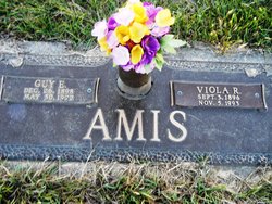
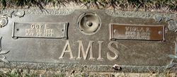
Viola Riga Hennings Amis
| Birth | : | 3 Sep 1896 Iowa, USA |
| Death | : | 5 Nov 1993 Spencer, Clay County, Iowa, USA |
| Burial | : | North Lawn Cemetery, Spencer, Clay County, USA |
| Coordinate | : | 43.1600000, -95.1470000 |
| Description | : | Daughter of Adolph John Hennings 1868 – 1957 and Fredericka "Riga" Schade 1877 – 1956 Wife of Theodore Popp b. December 17, 1887 in Germany d. October 27, 1913. Married 19 Feb 1913 O'Brien County, Iowa Wife of Bernard Helmuth Pauls b. April 23, 1891 in Kiel, Schleswig-Holstein, Germany d. March 3, 1929 in Iowa. Married 30 Aug 1915 Children: ✿ Orpna Madeline Pauls Kriens b. Apr 22 1916 ✿ Orville Adolph Pauls 1918 – 1970 ✿ Bernard Pauls b. Mar 1922 Wife of Guy Ezra Amis Married Aug 27 1930 Children: ✿ Delia Amis ✿ Jean Ann Amis 1933 – 1984 ✿ |
frequently asked questions (FAQ):
-
Where is Viola Riga Hennings Amis's memorial?
Viola Riga Hennings Amis's memorial is located at: North Lawn Cemetery, Spencer, Clay County, USA.
-
When did Viola Riga Hennings Amis death?
Viola Riga Hennings Amis death on 5 Nov 1993 in Spencer, Clay County, Iowa, USA
-
Where are the coordinates of the Viola Riga Hennings Amis's memorial?
Latitude: 43.1600000
Longitude: -95.1470000
Family Members:
Parent
Spouse
Siblings

Children
Flowers:


Nearby Cemetories:
1. North Lawn Cemetery
Spencer, Clay County, USA
Coordinate: 43.1600000, -95.1470000
2. Dewey Readmore Books Memorial
Spencer, Clay County, USA
Coordinate: 43.1403999, -95.1443024
3. Riverside Cemetery
Spencer, Clay County, USA
Coordinate: 43.1441994, -95.1671982
4. Fairview Cemetery
Clay County, USA
Coordinate: 43.1899986, -95.0800018
5. Evergreen Cemetery
Clay County, USA
Coordinate: 43.2052994, -95.2086029
6. Dickens Cemetery
Dickens, Clay County, USA
Coordinate: 43.1280000, -95.0155000
7. Swedish Lutheran Cemetery
Royal, Clay County, USA
Coordinate: 43.0683000, -95.2350000
8. Little Sioux Lutheran Cemetery
Milford, Dickinson County, USA
Coordinate: 43.2702065, -95.2109528
9. Rosehill Cemetery
Clay County, USA
Coordinate: 43.0368996, -95.0919037
10. First Reformed Cemetery
Clay County, USA
Coordinate: 43.2399500, -95.2889000
11. Lone Tree Cemetery
Everly, Clay County, USA
Coordinate: 43.1411018, -95.3347015
12. Milford Cemetery
Milford, Dickinson County, USA
Coordinate: 43.3092003, -95.1481018
13. Lincoln Cemetery
Rossie, Clay County, USA
Coordinate: 43.0111008, -95.2313995
14. Calvary Cemetery
Milford, Dickinson County, USA
Coordinate: 43.3213997, -95.1688995
15. Logan Township Cemetery
Clay County, USA
Coordinate: 43.0489006, -94.9747009
16. Liberty Cemetery
Greenville, Clay County, USA
Coordinate: 42.9897003, -95.1417007
17. Willow Creek Cemetery
Royal, Clay County, USA
Coordinate: 43.0214005, -95.2885971
18. Clay Center Cemetery
Royal, Clay County, USA
Coordinate: 43.0410995, -95.3272018
19. TriMello Cemetery
Royal, Clay County, USA
Coordinate: 43.0682983, -95.3728027
20. Crown Hill Cemetery
Ruthven, Palo Alto County, USA
Coordinate: 43.1328011, -94.8878021
21. Calvary Cemetery
Ruthven, Palo Alto County, USA
Coordinate: 43.1314011, -94.8869019
22. Zion Methodist Cemetery
Clay County, USA
Coordinate: 42.9808006, -95.2497025
23. Westport Cemetery
Dickinson County, USA
Coordinate: 43.3130989, -95.3289032
24. Okoboji Cemetery
Arnolds Park, Dickinson County, USA
Coordinate: 43.3649406, -95.1303558