

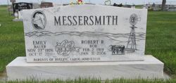
Emily “Myrtle” Bauer Messersmith
| Birth | : | 27 Nov 1926 Box Butte County, Nebraska, USA |
| Death | : | 17 Oct 2011 Alliance, Box Butte County, Nebraska, USA |
| Burial | : | Alliance Cemetery, Alliance, Box Butte County, USA |
| Coordinate | : | 42.1104965, -102.8367996 |
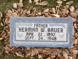
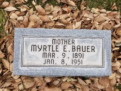
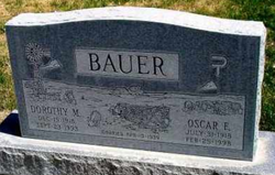
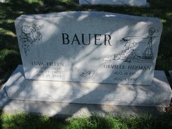
| Description | : | Emily "Myrtle" Messersmith, 84, died Monday, Oct. 17, 2011, at the Good Samaritan Health Care Center. The youngest of five children and the only girl, Emily was born Nov. 27, 1926, 8 miles northeast of Alliance on the home ranch of her parents Herman W. and Myrtle (Carey) Bauer. Emily attended grade school at Box Butte County District 78 and graduated from Alliance High School with the class of 1943. On Jan. 6, 1945 Emily married Robert Messersmith in Alliance. They settled on the old Farrow Homestead northwest of the F.E. Messersmith ranch where they raised registered Hereford cattle, registered... Read More |
frequently asked questions (FAQ):
-
Where is Emily “Myrtle” Bauer Messersmith's memorial?
Emily “Myrtle” Bauer Messersmith's memorial is located at: Alliance Cemetery, Alliance, Box Butte County, USA.
-
When did Emily “Myrtle” Bauer Messersmith death?
Emily “Myrtle” Bauer Messersmith death on 17 Oct 2011 in Alliance, Box Butte County, Nebraska, USA
-
Where are the coordinates of the Emily “Myrtle” Bauer Messersmith's memorial?
Latitude: 42.1104965
Longitude: -102.8367996
Family Members:
Parent
Spouse
Siblings
Children

Flowers:


Nearby Cemetories:
1. Alliance Cemetery
Alliance, Box Butte County, USA
Coordinate: 42.1104965, -102.8367996
2. Calvary Cemetery
Alliance, Box Butte County, USA
Coordinate: 42.1264000, -102.8569031
3. Immanuel Lutheran Church Columbarium
Alliance, Box Butte County, USA
Coordinate: 42.1053100, -102.8711700
4. United Methodist Church Columbarium
Alliance, Box Butte County, USA
Coordinate: 42.1013300, -102.8710400
5. Saint Matthews Episcopal Church Columbarium
Alliance, Box Butte County, USA
Coordinate: 42.1106300, -102.8748000
6. Saint Johns United Lutheran Church Columbarium
Alliance, Box Butte County, USA
Coordinate: 42.1178900, -102.8794100
7. Nebraska Veterans Cemetery
Alliance, Box Butte County, USA
Coordinate: 42.0745700, -102.8182800
8. Letan Cemetery
Letan, Box Butte County, USA
Coordinate: 42.0162290, -102.9367660
9. Fairview Cemetery
Alliance, Box Butte County, USA
Coordinate: 42.2409160, -102.7879280
10. Evergreen Cemetery
Alliance, Box Butte County, USA
Coordinate: 42.0244000, -103.0542000
11. Antioch Cemetery
Sheridan County, USA
Coordinate: 42.0661480, -102.5874600
12. Saint Johns Lutheran Cemetery
Hemingford, Box Butte County, USA
Coordinate: 42.2785520, -103.0046210
13. Nonpareil Cemetery
Hemingford, Box Butte County, USA
Coordinate: 42.2631149, -103.0824258
14. Pioneer-Box Butte Cemetery
Box Butte County, USA
Coordinate: 42.3640700, -102.8502400
15. Hemingford Cemetery
Hemingford, Box Butte County, USA
Coordinate: 42.3125000, -103.0541992
16. Lakeside Cemetery
Lakeside, Sheridan County, USA
Coordinate: 42.0529850, -102.4274100
17. Katen Cemetery
Box Butte County, USA
Coordinate: 42.4267006, -102.8908005
18. Snake Creek Cemetery
Box Butte County, USA
Coordinate: 42.0889015, -103.2742004
19. Angora Cemetery
Angora, Morrill County, USA
Coordinate: 41.8577995, -103.1306000
20. Neely Flat Cemetery
Sheridan County, USA
Coordinate: 42.4000015, -102.5958023
21. Ball Cemetery
Hemingford, Box Butte County, USA
Coordinate: 42.3372300, -103.2293300
22. Saint Peters Cemetery
Sheridan County, USA
Coordinate: 42.4975014, -102.7161026
23. Lawn Cemetery
Box Butte County, USA
Coordinate: 42.3224630, -103.3083830
24. Ellsworth Catholic Cemetery
Sheridan County, USA
Coordinate: 42.0575320, -102.2799959