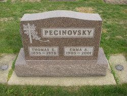
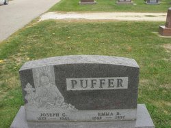
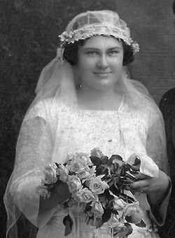
Emma Ann Puffer Pecinovsky
| Birth | : | 5 Jul 1905 Iowa, USA |
| Death | : | 15 Feb 2001 Winneshiek County, Iowa, USA |
| Burial | : | Riverside Cemetery, Washburn, Aroostook County, USA |
| Coordinate | : | 46.7785492, -68.1552277 |
| Description | : | Emma Pecinovsky, 95, of Spillville, died Thursday, Feb. 15, 2001 at the Colonial Manor Nursing Home in Elma, Iowa. Funeral Mass was held at 11 a.m. Monday, Feb. 19 at St. Wenceslaus Catholic Church in Spillville, with Rev. Donald Hawes officiating. Interment was in St. Wenceslaus Cemetery in Spillville, with Balik Funeral Home of Spillville handling arrangements. Emma Ann Pecinovsky was born July 5, 1905 to Joseph and Emma (Bouska) Puffer on the family farm near Conover. She attended the Conover School, and in 1945 moved to town with her parents. She had always helped on the family farm and... Read More |
frequently asked questions (FAQ):
-
Where is Emma Ann Puffer Pecinovsky's memorial?
Emma Ann Puffer Pecinovsky's memorial is located at: Riverside Cemetery, Washburn, Aroostook County, USA.
-
When did Emma Ann Puffer Pecinovsky death?
Emma Ann Puffer Pecinovsky death on 15 Feb 2001 in Winneshiek County, Iowa, USA
-
Where are the coordinates of the Emma Ann Puffer Pecinovsky's memorial?
Latitude: 46.7785492
Longitude: -68.1552277
Family Members:
Parent
Spouse
Siblings
Flowers:
Nearby Cemetories:
1. Riverside Cemetery
Washburn, Aroostook County, USA
Coordinate: 46.7785492, -68.1552277
2. Washburn Riverside Extension Cemetery
Washburn, Aroostook County, USA
Coordinate: 46.7750816, -68.1517105
3. Castle Hill Cemetery
Castle Hill, Aroostook County, USA
Coordinate: 46.7346840, -68.1792210
4. Crouseville Cemetery
Crouseville, Aroostook County, USA
Coordinate: 46.7574997, -68.0768967
5. Hillside Grove Cemetery
Crouseville, Aroostook County, USA
Coordinate: 46.7566760, -68.0765500
6. Fairview Cemetery
Perham, Aroostook County, USA
Coordinate: 46.8666992, -68.2086029
7. Old Mill Town Cemetery
Mapleton, Aroostook County, USA
Coordinate: 46.6815700, -68.1609100
8. Northern Maine Veterans Cemetery
Caribou, Aroostook County, USA
Coordinate: 46.8512400, -68.0428500
9. Lyndon Center Cemetery
Caribou, Aroostook County, USA
Coordinate: 46.8022240, -67.9921920
10. Southside Cemetery
Mapleton, Aroostook County, USA
Coordinate: 46.6622050, -68.1633620
11. Tarr Cemetery
Castle Hill, Aroostook County, USA
Coordinate: 46.6664200, -68.2203800
12. Evergreen Cemetery
Caribou, Aroostook County, USA
Coordinate: 46.8524500, -68.0112700
13. Johnson Cemetery
Presque Isle, Aroostook County, USA
Coordinate: 46.7078209, -68.0069733
14. Thompson Burial Ground
Caribou, Aroostook County, USA
Coordinate: 46.8143280, -67.9821140
15. Alley Cemetery
Ashland, Aroostook County, USA
Coordinate: 46.7014730, -68.3049090
16. Holy Rosary Cemetery Old
Caribou, Aroostook County, USA
Coordinate: 46.8558510, -68.0046860
17. Saint Marys Cemetery
Presque Isle, Aroostook County, USA
Coordinate: 46.6930930, -68.0104730
18. Holy Rosary Cemetery New
Caribou, Aroostook County, USA
Coordinate: 46.8845820, -68.0420660
19. Saint Marys Chapman Street Cemetery
Presque Isle, Aroostook County, USA
Coordinate: 46.6754150, -68.0215990
20. Grendell Cemetery
Chapman, Aroostook County, USA
Coordinate: 46.6364010, -68.1318340
21. Bean Family Cemetery
Aroostook County, USA
Coordinate: 46.7396440, -67.9542600
22. Cochran Cemetery
Caribou, Aroostook County, USA
Coordinate: 46.8672220, -67.9902780
23. Greenridge Cemetery
Caribou, Aroostook County, USA
Coordinate: 46.7923622, -67.9321976
24. Fairmount Cemetery
Presque Isle, Aroostook County, USA
Coordinate: 46.6628075, -68.0077744

