
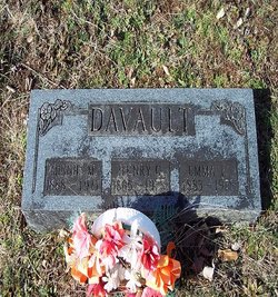
Emma Isabelle Upchurch Davault
| Birth | : | 28 Oct 1883 Marble Hill, Bollinger County, Missouri, USA |
| Death | : | 11 Dec 1978 Farmington, St. Francois County, Missouri, USA |
| Burial | : | Glen Allen Cemetery, Glenallen, Bollinger County, USA |
| Coordinate | : | 37.3201100, -90.0320100 |
| Description | : | Married Henry 'Cash' Cassius Davault 27/Jan/1911 at Bollinger Co., MO. Emma Isabel Davault, 95 of Rt. 1, Weingarten, died Dec. 11, 1978 at Farmington Community Hospital. She was born Oct. 20, 1883 near Marble Hill, a daughter of the late John and Nancy (Lincoln) Upchurch. Her husband H. C. Davault, preceded her in death. Mrs. Davault was a member of East Bonne Terre Baptist Church since 1930. Surviving are a daughter, Connie Davault of St. Louis, Mo.; a son, Ora Davault of Rt. 1, Weingarten, Mo.; four grandchildren; six great-grandchildren; one brother, Jake Upchurch of Desloge, Mo.; and several nieces and nephews. She... Read More |
frequently asked questions (FAQ):
-
Where is Emma Isabelle Upchurch Davault's memorial?
Emma Isabelle Upchurch Davault's memorial is located at: Glen Allen Cemetery, Glenallen, Bollinger County, USA.
-
When did Emma Isabelle Upchurch Davault death?
Emma Isabelle Upchurch Davault death on 11 Dec 1978 in Farmington, St. Francois County, Missouri, USA
-
Where are the coordinates of the Emma Isabelle Upchurch Davault's memorial?
Latitude: 37.3201100
Longitude: -90.0320100
Family Members:
Parent
Spouse
Siblings
Children


Flowers:


Nearby Cemetories:
1. Upper Deck Cemetery
Glenallen, Bollinger County, USA
Coordinate: 37.3236008, -90.0444031
2. Myers Cemetery
Glenallen, Bollinger County, USA
Coordinate: 37.3171997, -90.0096970
3. Lower Deck Cemetery
Lutesville, Bollinger County, USA
Coordinate: 37.3078003, -90.0119019
4. Buehler Cemetery
Glenallen, Bollinger County, USA
Coordinate: 37.3466988, -89.9989014
5. Slaybaugh Cemetery
Lutesville, Bollinger County, USA
Coordinate: 37.2982150, -89.9851870
6. El Nathan Cemetery
Marble Hill, Bollinger County, USA
Coordinate: 37.3086710, -89.9757960
7. Marble Hill Cemetery
Marble Hill, Bollinger County, USA
Coordinate: 37.3032799, -89.9701309
8. Dry Creek Cemetery
Lutesville, Bollinger County, USA
Coordinate: 37.2675018, -90.0291977
9. Hahn Cemetery
Lutesville, Bollinger County, USA
Coordinate: 37.2886009, -89.9772034
10. Shrum Cemetery
Hurricane, Bollinger County, USA
Coordinate: 37.3751500, -90.0144800
11. Baker Cemetery
Marble Hill, Bollinger County, USA
Coordinate: 37.2722015, -89.9869003
12. McMahan Cemetery
Bessville, Bollinger County, USA
Coordinate: 37.3767014, -90.0597000
13. Shell Cemetery
Lutesville, Bollinger County, USA
Coordinate: 37.2839012, -89.9693985
14. Bollinger County Memorial Park Cemetery
Marble Hill, Bollinger County, USA
Coordinate: 37.2689018, -89.9871979
15. Wallis Cemetery
Hurricane, Bollinger County, USA
Coordinate: 37.3800011, -90.0081024
16. Shelton Cemetery
Huxie, Bollinger County, USA
Coordinate: 37.2556000, -90.0481033
17. Myers Cemetery
Huxie, Bollinger County, USA
Coordinate: 37.2677994, -90.0839005
18. Hahn Chapel Cemetery
Marble Hill, Bollinger County, USA
Coordinate: 37.3061638, -89.9492645
19. Bess Cemetery
Hurricane, Bollinger County, USA
Coordinate: 37.3807983, -89.9927979
20. Floyd Cemetery
Grassy, Bollinger County, USA
Coordinate: 37.2808647, -90.1035919
21. New Trace Creek Baptist Church Cemetery
Glenallen, Bollinger County, USA
Coordinate: 37.3307190, -90.1182785
22. Moores Cemetery
Bollinger County, USA
Coordinate: 37.3883018, -90.0522003
23. Patterson Family Cemetery
Bollinger County, USA
Coordinate: 37.2511100, -90.0107100
24. Burton Cemetery
Marble Hill, Bollinger County, USA
Coordinate: 37.3722000, -89.9697037