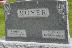
Emma Jane Myers Royer
| Birth | : | 1 Jul 1873 |
| Death | : | 22 Nov 1938 |
| Burial | : | Rose Hill Cemetery, Marion, Marion County, USA |
| Coordinate | : | 34.1775017, -79.3806000 |
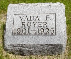
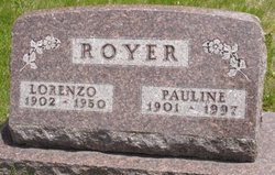
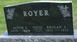
| Description | : | Emma Jane was born in Jo Davis County, Illinois near Nora, July 1, 1873, and departed this life at her home near Adel, Iowa, Nov. 22, 1938, aged 65 years, 4 month and 21 days. At 3 years of age she moved with her parents from Illinois to Dallas County, Iowa and has always resided within a few miles of the Panther Creek Church of the Brethren. On January 1, 1896 she was united in marriage to Guy C. Royer and to this union four children were born, three sons and one daughter, Clayton M., Vada Fern, Lorenzo and Alton... Read More |
frequently asked questions (FAQ):
-
Where is Emma Jane Myers Royer's memorial?
Emma Jane Myers Royer's memorial is located at: Rose Hill Cemetery, Marion, Marion County, USA.
-
When did Emma Jane Myers Royer death?
Emma Jane Myers Royer death on 22 Nov 1938 in
-
Where are the coordinates of the Emma Jane Myers Royer's memorial?
Latitude: 34.1775017
Longitude: -79.3806000
Family Members:
Parent
Spouse
Siblings
Children
Flowers:
Nearby Cemetories:
1. Rose Hill Cemetery
Marion, Marion County, USA
Coordinate: 34.1775017, -79.3806000
2. Jackson-McGill Cemetery
Marion, Marion County, USA
Coordinate: 34.1772900, -79.3786400
3. Old Town Cemetery
Marion, Marion County, USA
Coordinate: 34.1791300, -79.3961600
4. Palmetto Memorial Gardens
Marion, Marion County, USA
Coordinate: 34.1862500, -79.3688900
5. Durant Cemetery
Marion, Marion County, USA
Coordinate: 34.1655998, -79.3878021
6. New Life Cemetery
Marion, Marion County, USA
Coordinate: 34.1622009, -79.3692017
7. The Greater Highway Church of Christ Cemetery
Marion, Marion County, USA
Coordinate: 34.1722810, -79.4043410
8. Gasque Cemetery
Marion County, USA
Coordinate: 34.2098000, -79.3971300
9. Brown Cemetery
Marion County, USA
Coordinate: 34.1678009, -79.3396988
10. Smithey Cemetery
Marion County, USA
Coordinate: 34.1436005, -79.3443985
11. Little Bethel Baptist Church Cemetery
Mullins, Marion County, USA
Coordinate: 34.1592880, -79.3290250
12. Giles Cemetery
Marion, Marion County, USA
Coordinate: 34.1313500, -79.3914000
13. End of the Road Cemetery
Marion, Marion County, USA
Coordinate: 34.2240620, -79.3912079
14. Caulder Cemetery
Marion, Marion County, USA
Coordinate: 34.1970240, -79.3271550
15. Baker Cemetery
Marion, Marion County, USA
Coordinate: 34.1278000, -79.3835983
16. Devotion Gardens
Mullins, Marion County, USA
Coordinate: 34.1890000, -79.3200000
17. Wall Mausoleum
Marion, Marion County, USA
Coordinate: 34.2344800, -79.3823000
18. Livingston Cemetery
Marion County, USA
Coordinate: 34.1460991, -79.3206024
19. Foxworth Family Cemetery
Marion County, USA
Coordinate: 34.1288890, -79.4229130
20. Tranquil Methodist Church Cemetery
Marion, Marion County, USA
Coordinate: 34.2004000, -79.3128000
21. Ammons Cemetery
Marion County, USA
Coordinate: 34.1342010, -79.3261032
22. Spring Branch Cemetery
Spring Branch, Marion County, USA
Coordinate: 34.2425003, -79.3925018
23. Spring Branch Baptist Church Cemetery
Spring Branch, Marion County, USA
Coordinate: 34.2420998, -79.3957977
24. Smith-Waller Cemetery
Marion, Marion County, USA
Coordinate: 34.1535988, -79.3041992

