

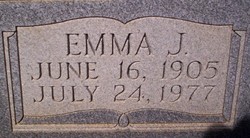
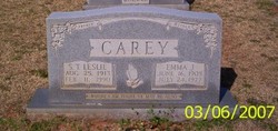
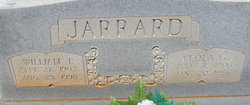
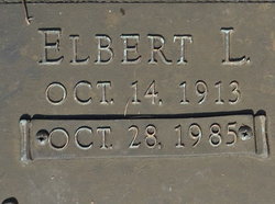
Emma Jarrard Carey
| Birth | : | 16 Jun 1905 Hall County, Georgia, USA |
| Death | : | 24 Jul 1977 Georgia, USA |
| Burial | : | Trinity Cemetery, Tolley, Renville County, USA |
| Coordinate | : | 48.7261009, -101.8341980 |
frequently asked questions (FAQ):
-
Where is Emma Jarrard Carey's memorial?
Emma Jarrard Carey's memorial is located at: Trinity Cemetery, Tolley, Renville County, USA.
-
When did Emma Jarrard Carey death?
Emma Jarrard Carey death on 24 Jul 1977 in Georgia, USA
-
Where are the coordinates of the Emma Jarrard Carey's memorial?
Latitude: 48.7261009
Longitude: -101.8341980
Family Members:
Parent
Spouse
Siblings
Flowers:


Nearby Cemetories:
1. Trinity Cemetery
Tolley, Renville County, USA
Coordinate: 48.7261009, -101.8341980
2. Saint Charles Cemetery
Tolley, Renville County, USA
Coordinate: 48.7340012, -101.8345108
3. McKinney Cemetery
Tolley, Renville County, USA
Coordinate: 48.7594261, -101.7830963
4. Saint Johns United Lutheran Cemetery
Mohall, Renville County, USA
Coordinate: 48.7928429, -101.7149429
5. Evanger Lutheran Cemetery
Tolley, Renville County, USA
Coordinate: 48.8362990, -101.9006560
6. Greenfield Cemetery
Ward County, USA
Coordinate: 48.5974998, -101.8653030
7. Trinity Lutheran Cemetery
Kenmare, Ward County, USA
Coordinate: 48.7335590, -102.0646290
8. Hamerly Lutheran Cemetery
Mohall, Renville County, USA
Coordinate: 48.8654700, -101.7270000
9. Rose Hill Cemetery
Kenmare, Ward County, USA
Coordinate: 48.6804600, -102.0723200
10. Saint Agnes Catholic Cemetery
Kenmare, Ward County, USA
Coordinate: 48.6804500, -102.0737200
11. Zion Lutheran Cemetery
Norma, Renville County, USA
Coordinate: 48.8499184, -101.9987030
12. Gethsemane Cemetery
Carpio, Ward County, USA
Coordinate: 48.5747261, -101.7124481
13. Lakeview Cemetery
Kenmare, Ward County, USA
Coordinate: 48.6627998, -102.1016998
14. Grano Cemetery
Grano, Renville County, USA
Coordinate: 48.6136017, -101.6038971
15. Saint John Cemetery
Mohall, Renville County, USA
Coordinate: 48.9184380, -101.7382889
16. Pleasant View Cemetery
Norma, Renville County, USA
Coordinate: 48.9087219, -101.9672775
17. Spring Valley Mennonite Cemetery
Kenaston, Ward County, USA
Coordinate: 48.5904617, -102.0805817
18. Donnybrook Community Cemetery
Donnybrook, Ward County, USA
Coordinate: 48.5171165, -101.8895264
19. Coulee Cemetery
Coulee, Mountrail County, USA
Coordinate: 48.5462723, -102.0065536
20. Holbrook Cemetery
Donnybrook, Ward County, USA
Coordinate: 48.5119019, -101.8944016
21. Bethany Lutheran Cemetery
Burke County, USA
Coordinate: 48.7349080, -102.1683880
22. Power Cemetery
Donnybrook, Ward County, USA
Coordinate: 48.5051627, -101.8884413
23. Prosperity Township Cemetery
Tolley, Renville County, USA
Coordinate: 48.9506200, -101.8462440
24. Loraine Cemetery
Loraine, Renville County, USA
Coordinate: 48.8672000, -101.5627000