

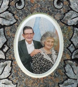
Emma Jean Smith Strong
| Birth | : | 29 Aug 1947 |
| Death | : | 3 Jan 2022 Tompkinsville, Monroe County, Kentucky, USA |
| Burial | : | Macedonia Cemetery, Moss, Clay County, USA |
| Coordinate | : | 36.5643997, -85.6110992 |
| Description | : | Obituary Mrs. Emma Jean Strong, age 74, of Moss, TN, passed away on Monday, January 3, 2022, at the Monroe County Medical Center. Funeral services will be held Sunday, January 9, 2022, at 1:00 p.m. in the chapel of the Upton Hay Funeral Home with Tim Eaton officiating and interment to follow in the Macedonia Cemetery. Visitation with the family will be Saturday, January 8, 2022, from 9:00 a.m. until 8:00 p.m. and Sunday, January 9, 2022, from 8:00 a.m. until time for the service. She is survived by her sons, Caley Strong, Eric (Jessica) Strong; daughter, Kimberly... Read More |
frequently asked questions (FAQ):
-
Where is Emma Jean Smith Strong's memorial?
Emma Jean Smith Strong's memorial is located at: Macedonia Cemetery, Moss, Clay County, USA.
-
When did Emma Jean Smith Strong death?
Emma Jean Smith Strong death on 3 Jan 2022 in Tompkinsville, Monroe County, Kentucky, USA
-
Where are the coordinates of the Emma Jean Smith Strong's memorial?
Latitude: 36.5643997
Longitude: -85.6110992
Family Members:
Parent

Spouse

Siblings
Flowers:


Nearby Cemetories:
1. Strong Family Cemetery
Clay County, USA
Coordinate: 36.5690700, -85.6042600
2. McLerran Cemetery
Moss, Clay County, USA
Coordinate: 36.5790000, -85.5973000
3. Kendall Cemetery
Moss, Clay County, USA
Coordinate: 36.5672540, -85.6362650
4. Moss Cemetery
Moss, Clay County, USA
Coordinate: 36.5911210, -85.6214460
5. Eads-Denton Cemetery
Pine Hill, Clay County, USA
Coordinate: 36.5644207, -85.6503187
6. Odle Cemetery
Clay County, USA
Coordinate: 36.5966988, -85.6085968
7. Spear Family Cemetery
Moss, Clay County, USA
Coordinate: 36.5933200, -85.5876500
8. Meadows Cemetery
Clay County, USA
Coordinate: 36.5946999, -85.5875015
9. Smith Cemetery
Pine Hill, Clay County, USA
Coordinate: 36.5714930, -85.6568170
10. Liberty Church Cemetery
Boles, Clay County, USA
Coordinate: 36.6010850, -85.6496830
11. Dalton Cemetery
Arcott, Clay County, USA
Coordinate: 36.5429540, -85.5546170
12. Moore Cemetery
Moss, Clay County, USA
Coordinate: 36.6113400, -85.6374980
13. Walker Reecer Cemetery
Celina, Clay County, USA
Coordinate: 36.5746290, -85.5480270
14. New Hope Cemetery
Clay County, USA
Coordinate: 36.6021996, -85.5653000
15. Archibald Plumlee Cemetery
Pine Hill, Clay County, USA
Coordinate: 36.5203018, -85.5682983
16. Pricetown Cemetery
Clay County, USA
Coordinate: 36.5422500, -85.6750670
17. Willhoite-Curtis Cemetery
Tompkinsville, Monroe County, USA
Coordinate: 36.6182208, -85.6442948
18. Lester Brown Family Cemetery
Arcott, Clay County, USA
Coordinate: 36.5205700, -85.5547530
19. Jonestown Cemetery
Clay County, USA
Coordinate: 36.5619011, -85.6921997
20. McColgan Cemetery
Clay County, USA
Coordinate: 36.5163994, -85.5560989
21. Roberts Cemetery
Celina, Clay County, USA
Coordinate: 36.5066986, -85.5727997
22. Freedom Cemetery #2
Tompkinsville, Monroe County, USA
Coordinate: 36.6284060, -85.6289940
23. Plumlee Cemetery
Celina, Clay County, USA
Coordinate: 36.5694280, -85.5282830
24. Moore Cemetery #1
Moss, Clay County, USA
Coordinate: 36.6164920, -85.6636620