
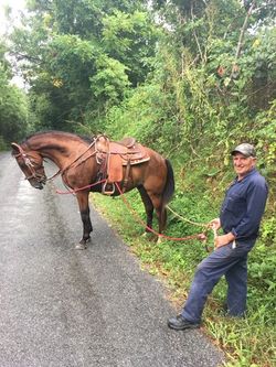
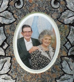
Larry Lee Smith
| Birth | : | 27 Jan 1954 |
| Death | : | 20 Mar 2019 Celina, Clay County, Tennessee, USA |
| Burial | : | Moore Cemetery, Moss, Clay County, USA |
| Coordinate | : | 36.6113400, -85.6374980 |
| Description | : | Larry Lee Smith, Age 65, Passed away on Wednesday March 20, 2019 as the result of a farming accident.. He was Born; January 27, 1954. Survivors: His Wife, Linda Gail (McLerran) Smith, A Son, Andy (Brandi) Smith, A Daughter, Sabrina (Chris) Conkin, Three Grandchildren, Three Brothers, Cornell, Cornelius and Kent Smith, Five Sisters, Christine Barrett, Emogene Strong, Eva Moore, Nora White and Diane Taylor... Funeral Services will be at 1:00 P. M. Saturday March 23, 2019 n Upton-Hay Funeral Home, with, Jonathan Hagan, Officiating. Burial... Read More |
frequently asked questions (FAQ):
-
Where is Larry Lee Smith's memorial?
Larry Lee Smith's memorial is located at: Moore Cemetery, Moss, Clay County, USA.
-
When did Larry Lee Smith death?
Larry Lee Smith death on 20 Mar 2019 in Celina, Clay County, Tennessee, USA
-
Where are the coordinates of the Larry Lee Smith's memorial?
Latitude: 36.6113400
Longitude: -85.6374980
Family Members:
Parent

Siblings

Flowers:


Nearby Cemetories:
1. Moore Cemetery
Moss, Clay County, USA
Coordinate: 36.6113400, -85.6374980
2. Willhoite-Curtis Cemetery
Tompkinsville, Monroe County, USA
Coordinate: 36.6182208, -85.6442948
3. Liberty Church Cemetery
Boles, Clay County, USA
Coordinate: 36.6010850, -85.6496830
4. Freedom Cemetery #2
Tompkinsville, Monroe County, USA
Coordinate: 36.6284060, -85.6289940
5. Moore Cemetery #1
Moss, Clay County, USA
Coordinate: 36.6164920, -85.6636620
6. Moss Cemetery
Moss, Clay County, USA
Coordinate: 36.5911210, -85.6214460
7. Old Bob Wood Place Cemetery
Boles, Monroe County, USA
Coordinate: 36.6325120, -85.6515600
8. Odle Cemetery
Clay County, USA
Coordinate: 36.5966988, -85.6085968
9. Baxter Cemetery
Hestand, Monroe County, USA
Coordinate: 36.6501460, -85.6264790
10. Beech Grove Cemetery
Harlan Crossroads, Monroe County, USA
Coordinate: 36.6319000, -85.6809000
11. Smith Cemetery
Pine Hill, Clay County, USA
Coordinate: 36.5714930, -85.6568170
12. Meadows Cemetery
Clay County, USA
Coordinate: 36.5946999, -85.5875015
13. Spear Family Cemetery
Moss, Clay County, USA
Coordinate: 36.5933200, -85.5876500
14. Kendall Cemetery
Moss, Clay County, USA
Coordinate: 36.5672540, -85.6362650
15. Henson Cemetery
Hestand, Monroe County, USA
Coordinate: 36.6553740, -85.6310890
16. Pitcock Cemetery
Clay County, USA
Coordinate: 36.5992012, -85.6911011
17. McLerran Cemetery
Moss, Clay County, USA
Coordinate: 36.5790000, -85.5973000
18. Eads-Denton Cemetery
Pine Hill, Clay County, USA
Coordinate: 36.5644207, -85.6503187
19. Mount Poland Cemetery
Tompkinsville, Monroe County, USA
Coordinate: 36.6604000, -85.6459000
20. Strong Family Cemetery
Clay County, USA
Coordinate: 36.5690700, -85.6042600
21. Macedonia Cemetery
Moss, Clay County, USA
Coordinate: 36.5643997, -85.6110992
22. Bailey Cemetery
Tompkinsville, Monroe County, USA
Coordinate: 36.6530991, -85.5994034
23. Hammer Cemetery
Tompkinsville, Monroe County, USA
Coordinate: 36.6641998, -85.6658020
24. New Hope Cemetery
Clay County, USA
Coordinate: 36.6021996, -85.5653000