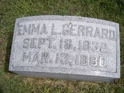
Emma L Gerrard
| Birth | : | 18 Sep 1832 |
| Death | : | 13 Mar 1880 Columbus, Platte County, Nebraska, USA |
| Burial | : | Mount Shasta Memorial Park, Mount Shasta, Siskiyou County, USA |
| Coordinate | : | 41.3182983, -122.3330994 |
| Description | : | Thanks to contributor #47012912; The Columbus Journal, March 17, 1880 DIED GERRARD--On Saturday, March 13, 1880, at 2 o'clock P.M., Emma Gerrard. The deceased was a Christian lady, faithful to her profession. Naturally of an amiable disposition, she gained many friends by her active, Christian benevolence. Her funeral took place at 10 o'clock Monday, from the Presbyterian Church, where religious services were conducted by Rev. Chas. N. Cate, in the presence of a large concourse of friends and acquaintances. |
frequently asked questions (FAQ):
-
Where is Emma L Gerrard's memorial?
Emma L Gerrard's memorial is located at: Mount Shasta Memorial Park, Mount Shasta, Siskiyou County, USA.
-
When did Emma L Gerrard death?
Emma L Gerrard death on 13 Mar 1880 in Columbus, Platte County, Nebraska, USA
-
Where are the coordinates of the Emma L Gerrard's memorial?
Latitude: 41.3182983
Longitude: -122.3330994
Family Members:
Parent
Siblings
Flowers:
Nearby Cemetories:
1. Mount Shasta Memorial Park
Mount Shasta, Siskiyou County, USA
Coordinate: 41.3182983, -122.3330994
2. Saint Barnabas Sacred Grounds
Mount Shasta, Siskiyou County, USA
Coordinate: 41.3201310, -122.3280340
3. Mott Cemetery
Mott, Siskiyou County, USA
Coordinate: 41.2607200, -122.2775500
4. Dunsmuir City Cemetery
Dunsmuir, Siskiyou County, USA
Coordinate: 41.2033350, -122.2748870
5. Lincoln Heights Cemetery
Weed, Siskiyou County, USA
Coordinate: 41.4372810, -122.3899290
6. Winema Cemetery
Weed, Siskiyou County, USA
Coordinate: 41.4395450, -122.3817780
7. Edgewood Cemetery
Edgewood, Siskiyou County, USA
Coordinate: 41.4516330, -122.4312440
8. McCloud Cemetery
McCloud, Siskiyou County, USA
Coordinate: 41.2327860, -122.1357720
9. Arbaugh-Dunlap Cemetery
Weed, Siskiyou County, USA
Coordinate: 41.4912500, -122.4077900
10. Conant Cemetery
Conant, Shasta County, USA
Coordinate: 41.1070700, -122.3334600
11. Foulke Cemetery
Gazelle, Siskiyou County, USA
Coordinate: 41.5144120, -122.5185930
12. Sims Cemetery
Lakehead, Shasta County, USA
Coordinate: 41.0755348, -122.3595657
13. Gazelle Cemetery
Siskiyou County, USA
Coordinate: 41.5133018, -122.5297012
14. Williams Cemetery
Siskiyou County, USA
Coordinate: 41.4642300, -122.6177900
15. Bell Cemetery
Gazelle, Siskiyou County, USA
Coordinate: 41.5082000, -122.5687300
16. Grave Creek Cemetery
Coffee Creek, Trinity County, USA
Coordinate: 41.2010300, -122.6459600
17. Ingle Indian Cemetery
Shasta County, USA
Coordinate: 41.0541600, -122.3815900
18. Portuguese Flat Cemetery
Lamoine, Shasta County, USA
Coordinate: 40.9992000, -122.4081700
19. Stoddard Family Cemetery
Coffee Creek, Trinity County, USA
Coordinate: 41.1381320, -122.6939980
20. Callahan Hayden Cemetery
Callahan, Siskiyou County, USA
Coordinate: 41.3076550, -122.7945570
21. Callahan Catholic Cemetery
Callahan, Siskiyou County, USA
Coordinate: 41.3058370, -122.7984540
22. Callahan Protestant Cemetery
Callahan, Siskiyou County, USA
Coordinate: 41.3066980, -122.7991490
23. Tacitus Arbuckle Gravesite
Siskiyou County, USA
Coordinate: 41.3486220, -122.8116430
24. Julien Cemetery
Siskiyou County, USA
Coordinate: 41.6502700, -122.5346900


