
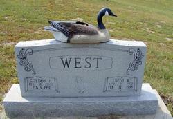
| Birth | : | 13 Jan 1931 Ogallala, Keith County, Nebraska, USA |
| Death | : | 24 Mar 2021 Genoa, Nance County, Nebraska, USA |
| Burial | : | Valley View Cemetery, Genoa, Nance County, USA |
| Coordinate | : | 41.4317017, -97.7319031 |
| Description | : | Erma Umbarger, 90, of Genoa, Nebraska, died Wednesday, March 24, 2021, at the Genoa Community Hospital LTC. A memorial service will be held on Tuesday, March 30, 11:00 A.M. at the Genoa United Methodist Church with Pastor Anny Kapundu and Pastor Vern Olson officiating. Erma Jean West was born January 13, 1931, in Ogallala, Nebraska to Gordon and Edith (Schuler) West. She grew up in Ogallala and graduated from Ogallala High School in 1949. She and George Umbarger met at Nebraska Wesleyan and were united in marriage on August 27, 1950 in Ogallala.... Read More |
frequently asked questions (FAQ):
-
Where is Erma Jean West Umbarger's memorial?
Erma Jean West Umbarger's memorial is located at: Valley View Cemetery, Genoa, Nance County, USA.
-
When did Erma Jean West Umbarger death?
Erma Jean West Umbarger death on 24 Mar 2021 in Genoa, Nance County, Nebraska, USA
-
Where are the coordinates of the Erma Jean West Umbarger's memorial?
Latitude: 41.4317017
Longitude: -97.7319031
Family Members:
Parent

Spouse

Siblings
Flowers:


Nearby Cemetories:
1. Valley View Cemetery
Genoa, Nance County, USA
Coordinate: 41.4317017, -97.7319031
2. Genoa Indian Industrial School Cemetery
Genoa, Nance County, USA
Coordinate: 41.4471700, -97.7218400
3. Saints Peter and Paul Cemetery
Krakow, Nance County, USA
Coordinate: 41.3908157, -97.7522888
4. Friends Cemetery
Oconee, Platte County, USA
Coordinate: 41.4775009, -97.6941986
5. Sunnyside Cemetery
Nance County, USA
Coordinate: 41.4016991, -97.8692017
6. Lingle Cemetery
Genoa, Nance County, USA
Coordinate: 41.5108000, -97.8384000
7. Gruetli Cemetery
Monroe, Platte County, USA
Coordinate: 41.4290000, -97.5810000
8. Silver Creek Cemetery
Silver Creek, Merrick County, USA
Coordinate: 41.3222008, -97.6830978
9. West Hill Cemetery
Platte County, USA
Coordinate: 41.5558014, -97.7161026
10. New Hope Cemetery
Monroe, Platte County, USA
Coordinate: 41.5413000, -97.6520000
11. Skeedee Cemetery
Nance County, USA
Coordinate: 41.5038986, -97.8850021
12. Saint Lawrence Cemetery
Silver Creek, Merrick County, USA
Coordinate: 41.2942009, -97.7052994
13. Saint Paul Evangelical Lutheran Cemetery
Monroe, Platte County, USA
Coordinate: 41.5651140, -97.6740360
14. Fairview Cemetery
Silver Creek, Merrick County, USA
Coordinate: 41.2920000, -97.8006000
15. Evergreen Cemetery
Saint Edward, Boone County, USA
Coordinate: 41.5677986, -97.8411026
16. Saint Edward Catholic Cemetery
Saint Edward, Boone County, USA
Coordinate: 41.5684800, -97.8424800
17. Palestine Cemetery
Rosenborg, Platte County, USA
Coordinate: 41.5980000, -97.7057000
18. Saint Johns Lutheran Church Cemetery
Polk County, USA
Coordinate: 41.3427940, -97.5421140
19. Zion Lutheran Grand Prairie Cemetery
Platte Center, Platte County, USA
Coordinate: 41.5546989, -97.5702972
20. German Lutheran Martens Cemetery
Platte Center, Platte County, USA
Coordinate: 41.5550200, -97.5707000
21. Greenwood Cemetery
Platte Center, Platte County, USA
Coordinate: 41.5708008, -97.5802994
22. Saint Stanislaus Catholic Cemetery
Duncan, Platte County, USA
Coordinate: 41.3926000, -97.4962000
23. Postville Cemetery
Platte County, USA
Coordinate: 41.5924644, -97.6203079
24. Jackson Cemetery
Duncan, Platte County, USA
Coordinate: 41.3946991, -97.4822006