
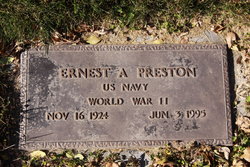
Ernest A Preston
| Birth | : | 16 Nov 1924 |
| Death | : | 3 Jun 1995 |
| Burial | : | St Cuthbert Churchyard, East Rainton, Metropolitan Borough of Sunderland, England |
| Coordinate | : | 54.8236030, -1.4790640 |
| Plot | : | Section Q |
frequently asked questions (FAQ):
-
Where is Ernest A Preston's memorial?
Ernest A Preston's memorial is located at: St Cuthbert Churchyard, East Rainton, Metropolitan Borough of Sunderland, England.
-
When did Ernest A Preston death?
Ernest A Preston death on 3 Jun 1995 in
-
Where are the coordinates of the Ernest A Preston's memorial?
Latitude: 54.8236030
Longitude: -1.4790640
Family Members:
Parent

Spouse
Siblings
Children
Flowers:


Nearby Cemetories:
1. St Cuthbert Churchyard
East Rainton, Metropolitan Borough of Sunderland, England
Coordinate: 54.8236030, -1.4790640
2. Houghton Cemetery
Houghton-le-Spring, Metropolitan Borough of Sunderland, England
Coordinate: 54.8347588, -1.4718029
3. St. Michael's RC Cemetery
Houghton-le-Spring, Metropolitan Borough of Sunderland, England
Coordinate: 54.8364300, -1.4714100
4. Hetton Cemetery
Hetton-le-Hole, Metropolitan Borough of Sunderland, England
Coordinate: 54.8256830, -1.4551984
5. St. Nicholas Churchyard
Hetton-le-Hole, Metropolitan Borough of Sunderland, England
Coordinate: 54.8201690, -1.4518480
6. St Michael & All Angels Churchyard
Houghton-le-Spring, Metropolitan Borough of Sunderland, England
Coordinate: 54.8421730, -1.4688210
7. Lyons St Michael & All Angels Churchyard
Houghton-le-Spring, Metropolitan Borough of Sunderland, England
Coordinate: 54.8423530, -1.4691540
8. Houghton Hillside Cemetery
Houghton-le-Spring, Metropolitan Borough of Sunderland, England
Coordinate: 54.8474737, -1.4641516
9. Easington Lane Cemetery
Easington Lane, Metropolitan Borough of Sunderland, England
Coordinate: 54.8103877, -1.4295255
10. St. Matthews Churchyard
Newbottle, Metropolitan Borough of Sunderland, England
Coordinate: 54.8575650, -1.4719100
11. Finchale Priory
Great Lumley, Durham Unitary Authority, England
Coordinate: 54.8181120, -1.5403970
12. St Laurence Churchyard
Pittington, Durham Unitary Authority, England
Coordinate: 54.7859220, -1.4907670
13. Great Lumley Cemetery
Great Lumley, Durham Unitary Authority, England
Coordinate: 54.8362470, -1.5421175
14. Christchurch Churchyard
Great Lumley, Durham Unitary Authority, England
Coordinate: 54.8370890, -1.5417950
15. St. Barnabas Churchyard
Bournmoor, Durham Unitary Authority, England
Coordinate: 54.8571260, -1.5195110
16. Holy Trinity Churchyard
South Hetton, Durham Unitary Authority, England
Coordinate: 54.8006610, -1.4135640
17. Belmont Cemetery
Belmont, Durham Unitary Authority, England
Coordinate: 54.7869300, -1.5244800
18. St Aidan Churchyard
New Herrington, Metropolitan Borough of Sunderland, England
Coordinate: 54.8693700, -1.4680430
19. St. Mary Magdalene Churchyard
Belmont, Durham Unitary Authority, England
Coordinate: 54.7863510, -1.5292050
20. St Cuthbert's Churchyard
New Herrington, Metropolitan Borough of Sunderland, England
Coordinate: 54.8708720, -1.4579010
21. Murton Cemetery
Murton, Durham Unitary Authority, England
Coordinate: 54.8153330, -1.3916320
22. Holy Trinity Churchyard
Murton, Durham Unitary Authority, England
Coordinate: 54.8159880, -1.3899430
23. St. Mary the Virgin Churchyard
Sherburn, Durham Unitary Authority, England
Coordinate: 54.7744380, -1.5086620
24. St Joseph's Roman Catholic Churchyard
Murton, Durham Unitary Authority, England
Coordinate: 54.8155960, -1.3888230