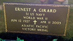
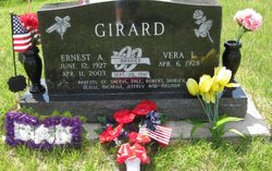
Ernest Admer “Ernie” Girard
| Birth | : | 12 Jun 1927 Clyde, Cloud County, Kansas, USA |
| Death | : | 11 Apr 2003 Wichita, Sedgwick County, Kansas, USA |
| Burial | : | Saint Concordia Cemetery, Concordia, Cloud County, USA |
| Coordinate | : | 39.5593800, -97.6503100 |
| Plot | : | Block 205.20 |
| Inscription | : | Married Sept. 20, 1947 Parents of Sheryl, Dale, Robert, Shirley, Denise, Michelle, Jeffrey and Melinda |
| Description | : | Blade-Empire - April 14, 2003 Ernest "Ernie" Girard, 75, Concordia, Kansas, died April 11, 2003, at Via Christi-St. Joseph, Wichita. He was born June 12, 1927, in Clyde, to Eugene and Laura Couture Girard. He attended the Morganville High School, Morganville, Kan., and then served in the United States Navy in Guam during World War II. He was married to Vera L. Wurtz on September 20, 1947, in Concordia. He retired from Southwestern Bell Telephone Company and had served in various capacities, including Toll Repeater man. He was a member of Our Lady of Perpetual Help Catholic Church and had... Read More |
frequently asked questions (FAQ):
-
Where is Ernest Admer “Ernie” Girard's memorial?
Ernest Admer “Ernie” Girard's memorial is located at: Saint Concordia Cemetery, Concordia, Cloud County, USA.
-
When did Ernest Admer “Ernie” Girard death?
Ernest Admer “Ernie” Girard death on 11 Apr 2003 in Wichita, Sedgwick County, Kansas, USA
-
Where are the coordinates of the Ernest Admer “Ernie” Girard's memorial?
Latitude: 39.5593800
Longitude: -97.6503100
Family Members:
Parent
Spouse
Siblings
Flowers:
Nearby Cemetories:
1. Saint Concordia Cemetery
Concordia, Cloud County, USA
Coordinate: 39.5593800, -97.6503100
2. Nazareth Convent Cemetery
Concordia, Cloud County, USA
Coordinate: 39.5614000, -97.6612000
3. Pleasant Hill Cemetery
Concordia, Cloud County, USA
Coordinate: 39.5583000, -97.6639023
4. Pleasant Hill Cemetery
Huscher, Cloud County, USA
Coordinate: 39.5093994, -97.6292038
5. Gotland Cemetery
Sibley Township, Cloud County, USA
Coordinate: 39.6091995, -97.6125031
6. Hefner Cemetery
Cloud County, USA
Coordinate: 39.5393400, -97.7218400
7. Sibley Cemetery
Sibley Township, Cloud County, USA
Coordinate: 39.6096992, -97.6908035
8. Rice Cemetery
Rice, Cloud County, USA
Coordinate: 39.5614014, -97.5552979
9. West Branch Cemetery
Buffalo Township, Cloud County, USA
Coordinate: 39.5391998, -97.7457962
10. Saron Lutheran Cemetery
Sibley Township, Cloud County, USA
Coordinate: 39.6385994, -97.6511002
11. Murdock Family Cemetery
Cloud County, USA
Coordinate: 39.6386400, -97.6504800
12. Nelson Family Cemetery
Sibley Township, Cloud County, USA
Coordinate: 39.6366600, -97.7010600
13. Nelson Cemetery
Rice, Cloud County, USA
Coordinate: 39.5257988, -97.5410995
14. Wilcox Cemetery
Cloud County, USA
Coordinate: 39.4925003, -97.7313995
15. Ezra Adkins Gravesite
Cloud County, USA
Coordinate: 39.6234500, -97.7372900
16. Fairview Cemetery
Buffalo Township, Cloud County, USA
Coordinate: 39.5889015, -97.7724991
17. Minersville Cemetery
Talmo, Republic County, USA
Coordinate: 39.6568330, -97.6229250
18. Kindel Cemetery
Center Township, Cloud County, USA
Coordinate: 39.4519005, -97.6464005
19. Dutton Family Cemetery
Sibley Township, Cloud County, USA
Coordinate: 39.6419440, -97.7430560
20. Green Mound Cemetery
Rice, Cloud County, USA
Coordinate: 39.5248450, -97.5081630
21. Walnut Grove Cemetery
Cloud County, USA
Coordinate: 39.5699997, -97.4993973
22. Hollis Cemetery
Cloud County, USA
Coordinate: 39.6383018, -97.5361023
23. Hall Cemetery
Cloud County, USA
Coordinate: 39.4455986, -97.7033005
24. Zion Cemetery
Agenda, Republic County, USA
Coordinate: 39.6749992, -97.5939026


