
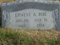
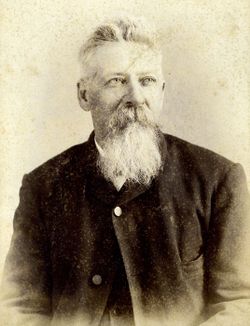
Ernest Albert Roe
| Birth | : | 28 Jan 1869 Vinland, Douglas County, Kansas, USA |
| Death | : | 31 Jul 1954 Vinland, Douglas County, Kansas, USA |
| Burial | : | Vinland Cemetery, Vinland, Douglas County, USA |
| Coordinate | : | 38.8485985, -95.1763992 |
frequently asked questions (FAQ):
-
Where is Ernest Albert Roe's memorial?
Ernest Albert Roe's memorial is located at: Vinland Cemetery, Vinland, Douglas County, USA.
-
When did Ernest Albert Roe death?
Ernest Albert Roe death on 31 Jul 1954 in Vinland, Douglas County, Kansas, USA
-
Where are the coordinates of the Ernest Albert Roe's memorial?
Latitude: 38.8485985
Longitude: -95.1763992
Family Members:
Parent
Spouse
Siblings
Children

Flowers:


Nearby Cemetories:
1. Stony Point Cemetery
Vinland, Douglas County, USA
Coordinate: 38.8249512, -95.2107391
2. Dow Cemetery
Vinland, Douglas County, USA
Coordinate: 38.8186620, -95.2143000
3. Brumbaugh Cemetery
Douglas County, USA
Coordinate: 38.8319200, -95.2330100
4. Breeze Family Cemetery
Pleasant Grove, Douglas County, USA
Coordinate: 38.8472800, -95.2480400
5. Blue Mound Cemetery
Lawrence, Douglas County, USA
Coordinate: 38.9046600, -95.1865400
6. Ulrich Cemetery
Pleasant Grove, Douglas County, USA
Coordinate: 38.8395740, -95.2531810
7. Clearfield Cemetery
Clearfield, Douglas County, USA
Coordinate: 38.8260002, -95.0930023
8. County Poor Farm Cemetery
Douglas County, USA
Coordinate: 38.9119400, -95.2214600
9. Richland Cemetery
Lawrence, Douglas County, USA
Coordinate: 38.8768997, -95.2630997
10. Kennedy Cemetery
Douglas County, USA
Coordinate: 38.9112900, -95.2269200
11. Marshall Cemetery
Douglas County, USA
Coordinate: 38.9040800, -95.2446700
12. Deay Cemetery
Eudora, Douglas County, USA
Coordinate: 38.8546486, -95.0749435
13. Oakwood Cemetery
Baldwin City, Douglas County, USA
Coordinate: 38.7694016, -95.1825027
14. Pleasant Hill Cemetery
Pleasant Grove, Douglas County, USA
Coordinate: 38.8535995, -95.2794037
15. Prairie City Cemetery
Baldwin City, Douglas County, USA
Coordinate: 38.7689018, -95.2050018
16. Mount Calvary Cemetery
Baldwin City, Douglas County, USA
Coordinate: 38.7687988, -95.2049713
17. Miller Family Cemetery
Baldwin City, Douglas County, USA
Coordinate: 38.7688751, -95.2146683
18. Baldwin City Cemetery
Baldwin City, Douglas County, USA
Coordinate: 38.7612953, -95.1862869
19. Cemetery Beni Israel
Eudora, Douglas County, USA
Coordinate: 38.9280128, -95.1122208
20. Dutton Cemetery
Douglas County, USA
Coordinate: 38.8989800, -95.2790600
21. Black Jack Cemetery
Douglas County, USA
Coordinate: 38.7660400, -95.1159400
22. Franklin Cemetery
Douglas County, USA
Coordinate: 38.9437523, -95.1869431
23. Haskell Cemetery
Lawrence, Douglas County, USA
Coordinate: 38.9353790, -95.2284241
24. Saint Johns Catholic Cemetery
Douglas County, USA
Coordinate: 38.9437900, -95.1919600