
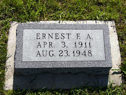
Ernest Frederick Arthur Ehrenfried
| Birth | : | 3 Apr 1911 Summerset Township, Adair County, Iowa, USA |
| Death | : | 23 Aug 1948 Summerset Township, Adair County, Iowa, USA |
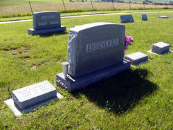
| Burial | : | Valley Cemetery, Valley, Douglas County, USA |
| Coordinate | : | 41.3446999, -96.3794022 |
| Plot | : | lot 17 second addition |
| Description | : | The Creston News Advertiser August 26, 1948 Greenfield Farmer Takes Life Monday Funeral services for Ernest Ehrenfried, 37, were held at 2 p.m. today at the Lutheran church in Fontanelle. Burial was in the Fontanelle cemetery. Mr. Ehrenfried, a farmer living 4 1/2/ miles north of Greenfield, ended his life by hanging himself in a corn crib on his farm about noon Monday. Dr. C.D. Shope, Adair county coroner, investigated, but no inquest was held. Mr. Ehrenfried left a suicide note and relatives said he had been mentally depressed for some time. Surviving... Read More |
frequently asked questions (FAQ):
-
Where is Ernest Frederick Arthur Ehrenfried's memorial?
Ernest Frederick Arthur Ehrenfried's memorial is located at: Valley Cemetery, Valley, Douglas County, USA.
-
When did Ernest Frederick Arthur Ehrenfried death?
Ernest Frederick Arthur Ehrenfried death on 23 Aug 1948 in Summerset Township, Adair County, Iowa, USA
-
Where are the coordinates of the Ernest Frederick Arthur Ehrenfried's memorial?
Latitude: 41.3446999
Longitude: -96.3794022
Family Members:
Parent
Spouse

Siblings
Children
Flowers:


Nearby Cemetories:
1. Valley Cemetery
Valley, Douglas County, USA
Coordinate: 41.3446999, -96.3794022
2. Pleasant View Cemetery
Leshara, Saunders County, USA
Coordinate: 41.2994003, -96.4266968
3. Bender Cemetery
Saunders County, USA
Coordinate: 41.2740707, -96.3966904
4. Estina Cemetery
Leshara, Saunders County, USA
Coordinate: 41.2922000, -96.4497000
5. Little Flower Cemetery
Pohocco Township, Saunders County, USA
Coordinate: 41.3350860, -96.4834470
6. Elk City Cemetery
Elk City, Douglas County, USA
Coordinate: 41.3725014, -96.2763977
7. Mount Michael High School and Abbey Cemetery
Elkhorn, Douglas County, USA
Coordinate: 41.3157690, -96.2688670
8. Pohocco Lutheran Church Cemetery
Leshara, Saunders County, USA
Coordinate: 41.3462715, -96.5026627
9. Prospect Hill Cemetery
Elkhorn, Douglas County, USA
Coordinate: 41.2924995, -96.2577972
10. Arlington Cemetery
Arlington, Washington County, USA
Coordinate: 41.4597015, -96.3392029
11. Platteville Cemetery
Saunders County, USA
Coordinate: 41.3506012, -96.5410995
12. Saint James Episcopal Church Columbarium
Fremont, Dodge County, USA
Coordinate: 41.4334370, -96.4944130
13. Green Mound Cemetery
Saunders County, USA
Coordinate: 41.2855988, -96.5250015
14. Mount Calvary Cemetery
Elkhorn, Douglas County, USA
Coordinate: 41.2668991, -96.2474976
15. Hollst-Lawn Cemetery
Yutan, Saunders County, USA
Coordinate: 41.2200012, -96.4116974
16. Sunrise Cemetery
Wahoo Township, Saunders County, USA
Coordinate: 41.2192852, -96.3422492
17. Colby-Morley Cemetery
Arlington, Washington County, USA
Coordinate: 41.4664050, -96.3126470
18. Saint James Cemetery
Yutan, Saunders County, USA
Coordinate: 41.2193985, -96.4353027
19. First Congregational Church Columbarium
Fremont, Dodge County, USA
Coordinate: 41.4439000, -96.4974300
20. Saint Augustine of Canterbury Columbarium
Elkhorn, Douglas County, USA
Coordinate: 41.2582030, -96.2396490
21. Prairie View Cemetery
Washington, Washington County, USA
Coordinate: 41.4225006, -96.2241974
22. Brittin Cemetery
Elkhorn, Douglas County, USA
Coordinate: 41.2291985, -96.2683029
23. Memorial Cemetery
Fremont, Dodge County, USA
Coordinate: 41.4516210, -96.5058210
24. Ridge Cemetery
Fremont, Dodge County, USA
Coordinate: 41.4425011, -96.5231018