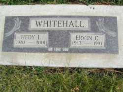
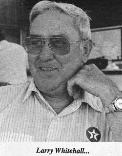
Ervin Clayton Whitehall
| Birth | : | 1 Nov 1917 Farmer, Douglas County, Washington, USA |
| Death | : | 11 Jul 1997 East Wenatchee, Douglas County, Washington, USA |
| Burial | : | Crescent Hill Cemetery, Scottsville, Allen County, USA |
| Coordinate | : | 36.7630997, -86.1757965 |
| Description | : | Wenatchee World - July 14, 1997 Ervin C. Whitehall, 79, a former longtime resident of Waterville, died on Friday evening, July 11, 1997, at Highline Convalescent Center in East Wenatchee after a long brave battle with Parkinson's disease and other complications. He spent his last days surrounded by his wife and family. Ervin was born on Nov. 1, 1917, to Lester and Grace (Jensen) Whitehall at Farmer. He attended school at Farmer and Withrow. He married Hedy I. Rinke on Nov. 18, 1939, in Waterville. They spent most of their lives wheat farming in the Farmer, Waterville and Coulee City areas. They moved... Read More |
frequently asked questions (FAQ):
-
Where is Ervin Clayton Whitehall's memorial?
Ervin Clayton Whitehall's memorial is located at: Crescent Hill Cemetery, Scottsville, Allen County, USA.
-
When did Ervin Clayton Whitehall death?
Ervin Clayton Whitehall death on 11 Jul 1997 in East Wenatchee, Douglas County, Washington, USA
-
Where are the coordinates of the Ervin Clayton Whitehall's memorial?
Latitude: 36.7630997
Longitude: -86.1757965
Family Members:
Parent
Spouse
Siblings
Flowers:
Nearby Cemetories:
1. Crescent Hill Cemetery
Scottsville, Allen County, USA
Coordinate: 36.7630997, -86.1757965
2. First Baptist Church Cemetery
Scottsville, Allen County, USA
Coordinate: 36.7574550, -86.1851710
3. Heeter-Griggs Graveyard
Scottsville, Allen County, USA
Coordinate: 36.7669800, -86.1874900
4. Cushenberry Family Cemetery
Allen County, USA
Coordinate: 36.7744800, -86.1652500
5. Crown Hill Cemetery
Scottsville, Allen County, USA
Coordinate: 36.7454830, -86.1921530
6. Bethlehem Missionary Church Cemetery
Allen County, USA
Coordinate: 36.7793884, -86.1573563
7. Briley-Manion Cemetery
Allen County, USA
Coordinate: 36.7584160, -86.2051750
8. Chestnut Point Baptist Cemetery
Scottsville, Allen County, USA
Coordinate: 36.7520320, -86.1371860
9. Corinth General Baptist Church Cemetery
Scottsville, Allen County, USA
Coordinate: 36.7795970, -86.1244700
10. Allen County Memorial Gardens
Scottsville, Allen County, USA
Coordinate: 36.7316740, -86.2161620
11. Durham Springs Cemetery
Scottsville, Allen County, USA
Coordinate: 36.7614098, -86.1146393
12. Dover Cemetery
Chapel Hill, Allen County, USA
Coordinate: 36.7120781, -86.1868210
13. Willoughby Family Cemetery
Allen County, USA
Coordinate: 36.8174700, -86.1495600
14. Harston Cemetery
Scottsville, Allen County, USA
Coordinate: 36.8091330, -86.1308500
15. Miller Cemetery
Scottsville, Allen County, USA
Coordinate: 36.7052900, -86.1579400
16. Hickory Hill Cemetery
Scottsville, Allen County, USA
Coordinate: 36.7447395, -86.2466125
17. New Bethel Methodist Cemetery
Scottsville, Allen County, USA
Coordinate: 36.7672882, -86.2524567
18. Mount Carmel Cemetery
Scottsville, Allen County, USA
Coordinate: 36.6990670, -86.1556900
19. Mount Pleasant United Methodist Church Cemetery
Scottsville, Allen County, USA
Coordinate: 36.7096100, -86.2274017
20. Old Path Church of God Cemetery
Allen County, USA
Coordinate: 36.7667400, -86.0883100
21. Maysville Church Cemetery
Scottsville, Allen County, USA
Coordinate: 36.7455040, -86.0862980
22. Bethel Methodist Church Cemetery
Allen County, USA
Coordinate: 36.7609600, -86.2685100
23. Doddy Church Cemetery
Scottsville, Allen County, USA
Coordinate: 36.6903460, -86.1404240
24. Liberty Church Cemetery
Allen County, USA
Coordinate: 36.8262100, -86.2335129


