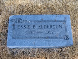
Essie Barnhart Alderson
| Birth | : | 7 Feb 1894 Iowa, USA |
| Death | : | 27 Apr 1927 Hartford, Lyon County, Kansas, USA |
| Burial | : | Bronson Cemetery, Bronson, Branch County, USA |
| Coordinate | : | 41.8699340, -85.1858320 |
| Description | : | KANSAS WOMAN LEAPS TO DEATH FROM TRESTLE BURLINGTON, KAN., April 28--(Spl)--Mrs. Fred Alderson, an inmate of the state sanitarium at Topeka, is believed to have jumped from a trestle just east of Hartford, late Wednesday night and drowned herself. The first hint that the woman might have drowned herself came about 11 o'clock Wednesday night when Frank Coffman, of Hartford, in driving over the bridge, noticed a woman's hat and coat on the rail. Investigating, he found a note signed by Mrs. Alderson which bid her husband "Good bye" and asked him to take good care of their... Read More |
frequently asked questions (FAQ):
-
Where is Essie Barnhart Alderson's memorial?
Essie Barnhart Alderson's memorial is located at: Bronson Cemetery, Bronson, Branch County, USA.
-
When did Essie Barnhart Alderson death?
Essie Barnhart Alderson death on 27 Apr 1927 in Hartford, Lyon County, Kansas, USA
-
Where are the coordinates of the Essie Barnhart Alderson's memorial?
Latitude: 41.8699340
Longitude: -85.1858320
Family Members:
Parent
Spouse
Children
Flowers:
Nearby Cemetories:
1. Bronson Cemetery
Bronson, Branch County, USA
Coordinate: 41.8699340, -85.1858320
2. Saint Marys Cemetery
Bronson, Branch County, USA
Coordinate: 41.8582993, -85.1939011
3. Snow Prairie Cemetery
Bethel, Branch County, USA
Coordinate: 41.8699989, -85.1408005
4. York Cemetery
Batavia, Branch County, USA
Coordinate: 41.9009350, -85.1318550
5. Curtis Cemetery
Bronson, Branch County, USA
Coordinate: 41.8039017, -85.1956024
6. North Gilead Cemetery
Gilead Township, Branch County, USA
Coordinate: 41.8039017, -85.1557999
7. Matteson Cemetery
Matteson, Branch County, USA
Coordinate: 41.9406013, -85.2046967
8. Adams Cemetery
Bronson, Branch County, USA
Coordinate: 41.8405991, -85.2767029
9. Pleasant Hill Cemetery
Noble Township, Branch County, USA
Coordinate: 41.7961110, -85.2111110
10. Dutch Settlement Cemetery
Bronson, Branch County, USA
Coordinate: 41.8106003, -85.2632980
11. Batavia Cemetery
Batavia, Branch County, USA
Coordinate: 41.9202778, -85.0975000
12. Card Cemetery
Bethel Township, Branch County, USA
Coordinate: 41.8544006, -85.0693970
13. South Gilead Cemetery
Bronson, Branch County, USA
Coordinate: 41.7733330, -85.1566670
14. Ovid Cemetery
Ovid Township, Branch County, USA
Coordinate: 41.8688580, -85.0484920
15. South Colon Cemetery
Colon, St. Joseph County, USA
Coordinate: 41.9199982, -85.3114014
16. Sanborn Cemetery
Burr Oak, St. Joseph County, USA
Coordinate: 41.8708000, -85.3305969
17. Burr Oak Township Cemetery
Burr Oak, St. Joseph County, USA
Coordinate: 41.8472214, -85.3319473
18. Tripp Cemetery
Batavia, Branch County, USA
Coordinate: 41.9425000, -85.0694440
19. East Gilead Cemetery
East Gilead, Branch County, USA
Coordinate: 41.7858330, -85.0825000
20. Trayer Cemetery
Bronson, Branch County, USA
Coordinate: 41.7705550, -85.2677770
21. Branch Cemetery
Coldwater, Branch County, USA
Coordinate: 41.9368200, -85.0485990
22. Lockwood Cemetery
Coldwater, Branch County, USA
Coordinate: 41.8837250, -85.0145170
23. Eroh Cemetery
Fawn River Township, St. Joseph County, USA
Coordinate: 41.8081017, -85.3375015
24. Freedom Cemetery
Fawn River, St. Joseph County, USA
Coordinate: 41.8064003, -85.3371964


