
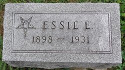
Essie E. Whitacre Grist
| Birth | : | 9 Mar 1898 Lancaster, Schuyler County, Missouri, USA |
| Death | : | 12 Jun 1931 Kirksville, Adair County, Missouri, USA |
| Burial | : | Calvary Cemetery, Winchendon, Worcester County, USA |
| Coordinate | : | 42.6805992, -72.0318985 |
| Description | : | married, daughter of John Whitacre and Ida Schull (Mikel?), wife of Edward (Edwin?) Grist d. cert 20414 |
frequently asked questions (FAQ):
-
Where is Essie E. Whitacre Grist's memorial?
Essie E. Whitacre Grist's memorial is located at: Calvary Cemetery, Winchendon, Worcester County, USA.
-
When did Essie E. Whitacre Grist death?
Essie E. Whitacre Grist death on 12 Jun 1931 in Kirksville, Adair County, Missouri, USA
-
Where are the coordinates of the Essie E. Whitacre Grist's memorial?
Latitude: 42.6805992
Longitude: -72.0318985
Family Members:
Parent

Spouse

Siblings
Flowers:


Nearby Cemetories:
1. Riverside Cemetery
Winchendon, Worcester County, USA
Coordinate: 42.6805992, -72.0263977
2. Massachusetts Veterans Memorial Cemetery
Winchendon, Worcester County, USA
Coordinate: 42.6851300, -72.0185200
3. Old Centre Burial Ground
Winchendon, Worcester County, USA
Coordinate: 42.6617012, -72.0366974
4. Robbins Cemetery
Rindge, Cheshire County, USA
Coordinate: 42.7266670, -72.0638890
5. Robbins Burial Ground
Rindge, Cheshire County, USA
Coordinate: 42.7268982, -72.0658035
6. Rand Cemetery
Rindge, Cheshire County, USA
Coordinate: 42.7350006, -72.0582962
7. New Boston Cemetery
Winchendon, Worcester County, USA
Coordinate: 42.6306000, -72.0860977
8. Hillside Cemetery
Rindge, Cheshire County, USA
Coordinate: 42.7463000, -72.0063900
9. Meeting House Cemetery
Rindge, Cheshire County, USA
Coordinate: 42.7501200, -72.0096700
10. Wood Family Cemetery
Rindge, Cheshire County, USA
Coordinate: 42.7457040, -71.9859410
11. Greenlawn Cemetery
Templeton, Worcester County, USA
Coordinate: 42.6124992, -72.0708008
12. Saint Josephs Cemetery
Gardner, Worcester County, USA
Coordinate: 42.5922012, -72.0391998
13. Wilder Cemetery
Rindge, Cheshire County, USA
Coordinate: 42.7395400, -71.9404900
14. Wildwood Cemetery
Gardner, Worcester County, USA
Coordinate: 42.5896988, -72.0306015
15. Fairbanks Cemetery
Ashburnham, Worcester County, USA
Coordinate: 42.6355220, -71.9236710
16. Meetinghouse Hill Cemetery
Ashburnham, Worcester County, USA
Coordinate: 42.6436900, -71.9176100
17. Saint Johns Cemetery
Gardner, Worcester County, USA
Coordinate: 42.5875015, -72.0207977
18. Notre Dame Cemetery
Gardner, Worcester County, USA
Coordinate: 42.5849991, -72.0222015
19. Riverside Cemetery
Royalston, Worcester County, USA
Coordinate: 42.6302986, -72.1453018
20. Jonas Alliene Cemetery
Royalston, Worcester County, USA
Coordinate: 42.6748790, -72.1656520
21. Cathedral of the Pines Cemetery
Rindge, Cheshire County, USA
Coordinate: 42.7749900, -71.9901800
22. New Cemetery
Ashburnham, Worcester County, USA
Coordinate: 42.6318400, -71.9137400
23. Crystal Lake Cemetery
Gardner, Worcester County, USA
Coordinate: 42.5833015, -71.9957962
24. Lawrence Brook Cemetery
Royalston, Worcester County, USA
Coordinate: 42.6693993, -72.1707993