
| Birth | : | 26 Mar 1898 Scotland County, Missouri, USA |
| Death | : | 9 Jul 1988 Chanute, Neosho County, Kansas, USA |
| Burial | : | Pukerimu Lawn Cemetery, Paeroa, Hauraki District, New Zealand |
| Coordinate | : | -37.3900600, 175.6908910 |
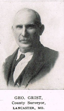
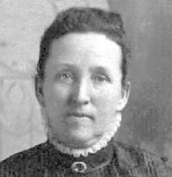
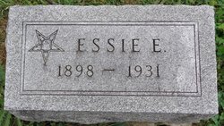
| Description | : | Edwin W. Grist, son of George and Constance (Farrell) Grist, was born near Bible Grove, Mo., March 26, 1898, and passed away Saturday, July 9, 1988, in a Chanute, Kan., hospital at the age of 90 years, three months, and 13 days. He was married to Essie Whitacre, and to this union a son, John George, was born. Essie died June 6, 1931. On June 14, 1964, he was married to Grace (Franklin) Nobles, who survives. Also surviving are his son, John, Tuscon [sic], Ariz.; a step-son, Don Cook, Des Moines, Ia.; a step-daughter, Louise McClure, Atlanta, Ia.;... Read More |
frequently asked questions (FAQ):
-
Where is Edwin Webster Grist's memorial?
Edwin Webster Grist's memorial is located at: Pukerimu Lawn Cemetery, Paeroa, Hauraki District, New Zealand.
-
When did Edwin Webster Grist death?
Edwin Webster Grist death on 9 Jul 1988 in Chanute, Neosho County, Kansas, USA
-
Where are the coordinates of the Edwin Webster Grist's memorial?
Latitude: -37.3900600
Longitude: 175.6908910
Family Members:
Parent
Spouse
Siblings
Flowers:


Nearby Cemetories:
1. Pukerimu Lawn Cemetery
Paeroa, Hauraki District, New Zealand
Coordinate: -37.3900600, 175.6908910
2. Tirohia
Paeroa, Hauraki District, New Zealand
Coordinate: -37.4381503, 175.6436459
3. Omahu Cemetery
Hikutaia, Thames-Coromandel District, New Zealand
Coordinate: -37.2707910, 175.6533300
4. Waihi Cemetery
Waihi, Hauraki District, New Zealand
Coordinate: -37.4093500, 175.8629600
5. Maukoro Cemetery
Morrinsville, Matamata-Piako District, New Zealand
Coordinate: -37.4614130, 175.5018220
6. Te Aroha Cemetery
Te Aroha, Matamata-Piako District, New Zealand
Coordinate: -37.5561450, 175.7109550
7. Ngatea Memorial Walls
Ngatea, Hauraki District, New Zealand
Coordinate: -37.2757990, 175.4915380
8. St Peters by the Sea
Waihi Beach, Western Bay of Plenty District, New Zealand
Coordinate: -37.4012045, 175.9369234
9. Whangamata Cemetery
Whangamata, Thames-Coromandel District, New Zealand
Coordinate: -37.2278330, 175.8553480
10. Tuapiro Cemetery
Katikati, Western Bay of Plenty District, New Zealand
Coordinate: -37.4987630, 175.9234740
11. Faulkner Urupā
Tauranga, Tauranga City, New Zealand
Coordinate: -37.4464650, 175.9540970
12. Totara Memorial Park
Thames, Thames-Coromandel District, New Zealand
Coordinate: -37.1653440, 175.5590990
13. Allan Block Cemetery
Whangamata, Thames-Coromandel District, New Zealand
Coordinate: -37.1794319, 175.8572147
14. Parawai Māori Cemetery
Parawai, Thames-Coromandel District, New Zealand
Coordinate: -37.1590100, 175.5640600
15. Katikati Cemetery
Katikati, Western Bay of Plenty District, New Zealand
Coordinate: -37.5824500, 175.9061600
16. Shortland Cemetery
Thames, Thames-Coromandel District, New Zealand
Coordinate: -37.1423500, 175.5571520
17. Piako Cemetery
Morrinsville, Matamata-Piako District, New Zealand
Coordinate: -37.6484900, 175.5412240
18. Morrinsville Old Cemetery
Morrinsville, Matamata-Piako District, New Zealand
Coordinate: -37.6531500, 175.5374260
19. Tararu Cemetery
Thames, Thames-Coromandel District, New Zealand
Coordinate: -37.1049590, 175.5189510
20. Makomako Urupā
Waitakaruru, Hauraki District, New Zealand
Coordinate: -37.2329470, 175.3389910
21. Waiterimu-Matahuru Cemetery
Waiterimu, Waikato District, New Zealand
Coordinate: -37.4452080, 175.2910660
22. Kaimai Flight 441 Air Crash Memorial
Gordon, Matamata-Piako District, New Zealand
Coordinate: -37.6960470, 175.8260440
23. Rukumoana Urupā
Matamata, Matamata-Piako District, New Zealand
Coordinate: -37.6976740, 175.5572500
24. Orini Cemetery
Orini, Waikato District, New Zealand
Coordinate: -37.5535200, 175.3222100