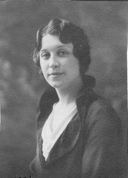
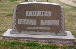
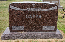
Estaleene M. Steil Godden
| Birth | : | 11 Feb 1889 Emmetsburg, Palo Alto County, Iowa, USA |
| Death | : | 2 Jun 1980 Kansas City, Clay County, Missouri, USA |
| Burial | : | Saint Johns Catholic Cemetery, Emmetsburg, Palo Alto County, USA |
| Coordinate | : | 43.0913200, -94.6790000 |
| Description | : | from the Emmetsburg Reporter, June 10, 1980 Services Held For Estaleene Godden Mrs. Estaleene M. Godden of Emmetsburg died Monday, June 2, 1980 at the Kansas City Research Hospital, Kansas City, Mo. She was 91. Services for Mrs. Godden were held Thursday, June 5, at 10 a.m. at the Assumption Catholic Church in Emmetsburg. The Rev. Charles Bormann officiated. Burial was in the St. John's Cemetery with Martin-Bails Funeral Home, Emmetsburg, in charge of arrangements. Casket bearers were Gordon Smith, Ray Beatty, Joseph Gappa, James E. Frambach, James Frambach, Jr., and Charles Smith. Rosary services were held Wednesday, June 4, 8 p.m. at the... Read More |
frequently asked questions (FAQ):
-
Where is Estaleene M. Steil Godden's memorial?
Estaleene M. Steil Godden's memorial is located at: Saint Johns Catholic Cemetery, Emmetsburg, Palo Alto County, USA.
-
When did Estaleene M. Steil Godden death?
Estaleene M. Steil Godden death on 2 Jun 1980 in Kansas City, Clay County, Missouri, USA
-
Where are the coordinates of the Estaleene M. Steil Godden's memorial?
Latitude: 43.0913200
Longitude: -94.6790000
Family Members:
Parent
Spouse
Siblings
Children
Flowers:
Nearby Cemetories:
1. Saint Johns Catholic Cemetery
Emmetsburg, Palo Alto County, USA
Coordinate: 43.0913200, -94.6790000
2. Evergreen Cemetery
Emmetsburg, Palo Alto County, USA
Coordinate: 43.0940018, -94.6791992
3. Vernon Township Cemetery
Vernon Township, Palo Alto County, USA
Coordinate: 43.1840000, -94.6185000
4. Saint Paul Lutheran Cemetery
Walnut Township, Palo Alto County, USA
Coordinate: 43.1866740, -94.7872050
5. Saint John's Lutheran Cemetery
Fairfield Township, Palo Alto County, USA
Coordinate: 43.1265000, -94.5017000
6. Riverside Cemetery
Fern Valley Township, Palo Alto County, USA
Coordinate: 43.0200000, -94.5220000
7. Saint Mary's Cemetery
Rush Lake Township, Palo Alto County, USA
Coordinate: 42.9560000, -94.6980000
8. Silver Lake Cemetery
Silver Lake Township, Palo Alto County, USA
Coordinate: 43.0386009, -94.8597031
9. Highland Cemetery
Highland Township, Palo Alto County, USA
Coordinate: 43.1497002, -94.8578033
10. Calvary Cemetery
Silver Lake Township, Palo Alto County, USA
Coordinate: 43.0386009, -94.8613968
11. North Saint John's Lutheran Cemetery
Independence Township, Palo Alto County, USA
Coordinate: 43.1696281, -94.5077438
12. Rush Lake Cemetery
Rush Lake Township, Palo Alto County, USA
Coordinate: 42.9497185, -94.7383270
13. Valley View Cemetery
Walnut Township, Palo Alto County, USA
Coordinate: 43.2428000, -94.7212000
14. Calvary Cemetery
Ruthven, Palo Alto County, USA
Coordinate: 43.1314011, -94.8869019
15. Lost Island Lutheran Cemetery
Lost Island Township, Palo Alto County, USA
Coordinate: 43.1980000, -94.8375000
16. Lincoln Cemetery
West Bend, Palo Alto County, USA
Coordinate: 42.9596842, -94.5602466
17. Crown Hill Cemetery
Ruthven, Palo Alto County, USA
Coordinate: 43.1328011, -94.8878021
18. Ellington Cemetery
Ellington Township, Palo Alto County, USA
Coordinate: 42.9377000, -94.6240400
19. Saint Luke's Lutheran Cemetery
Fairfield Township, Palo Alto County, USA
Coordinate: 43.1545000, -94.4723000
20. Saint Jacobs Cemetery
Graettinger, Palo Alto County, USA
Coordinate: 43.2546997, -94.7705994
21. Graettinger City Cemetery
Graettinger, Palo Alto County, USA
Coordinate: 43.2550011, -94.7722015
22. Saint Michaels Catholic Cemetery
Whittemore, Kossuth County, USA
Coordinate: 43.0827000, -94.4322500
23. Riverside Cemetery
West Bend, Palo Alto County, USA
Coordinate: 42.9512000, -94.5120000
24. Saint Pauls Lutheran Cemetery
Whittemore, Kossuth County, USA
Coordinate: 43.0530014, -94.4135971

