
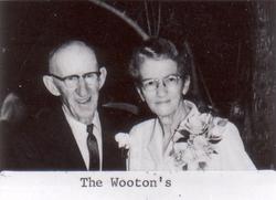
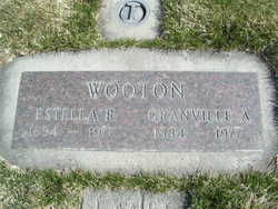
Estella Ruth Watson Wooton
| Birth | : | 9 Jun 1894 San Jose, Santa Clara County, California, USA |
| Death | : | 11 Jun 1977 Cashmere, Chelan County, Washington, USA |
| Burial | : | Lakeview Cemetery, Kenmare, Ward County, USA |
| Coordinate | : | 48.6627998, -102.1016998 |
| Plot | : | South Fraternal Row5 BLK6 L4A |
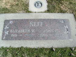
| Inscription | : | Granville A Wooton |
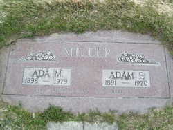
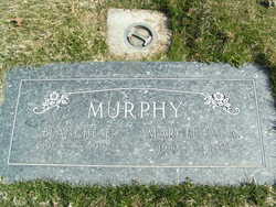
| Description | : | Estella R. Wooton, 83, Cashmere, a pioneer resident of Chelan, died Saturday evening in Cashmere. She was born Estella Watson on June 9, 1894 at San Jose, Calif., and moved to Chelan with her family in 1897. On Aug. 12, 1913, she married Granville Wooton at Wenatchee and following their marriage, they moved to Chelan. Surviving are her husband, at home; one daughter, Mrs. John Neff, Cashmere; one son, Ellis Wooton, Anaheim, Calif.; two sisters Ada Miller and Banche Murphy, both of Chelan; four grandchildren and two great-grandchildren. She was preceded in death by one brother and two sisters. |
frequently asked questions (FAQ):
-
Where is Estella Ruth Watson Wooton's memorial?
Estella Ruth Watson Wooton's memorial is located at: Lakeview Cemetery, Kenmare, Ward County, USA.
-
When did Estella Ruth Watson Wooton death?
Estella Ruth Watson Wooton death on 11 Jun 1977 in Cashmere, Chelan County, Washington, USA
-
Where are the coordinates of the Estella Ruth Watson Wooton's memorial?
Latitude: 48.6627998
Longitude: -102.1016998
Family Members:
Parent

Spouse
Siblings
Children
Flowers:


Nearby Cemetories:
1. Lakeview Cemetery
Kenmare, Ward County, USA
Coordinate: 48.6627998, -102.1016998
2. Saint Agnes Catholic Cemetery
Kenmare, Ward County, USA
Coordinate: 48.6804500, -102.0737200
3. Rose Hill Cemetery
Kenmare, Ward County, USA
Coordinate: 48.6804600, -102.0723200
4. Spring Valley Mennonite Cemetery
Kenaston, Ward County, USA
Coordinate: 48.5904617, -102.0805817
5. Trinity Lutheran Cemetery
Kenmare, Ward County, USA
Coordinate: 48.7335590, -102.0646290
6. Elmdale Lutheran Cemetery
Niobe, Ward County, USA
Coordinate: 48.6988983, -102.2127991
7. Bethany Lutheran Cemetery
Burke County, USA
Coordinate: 48.7349080, -102.1683880
8. Baden Cemetery
Baden, Ward County, USA
Coordinate: 48.5610700, -102.0823000
9. Our Saviors Lutheran Cemetery
Kenaston, Ward County, USA
Coordinate: 48.5604477, -102.1352158
10. Little Butte Cemetery
Bowbells, Burke County, USA
Coordinate: 48.7197310, -102.2769000
11. Coulee Cemetery
Coulee, Mountrail County, USA
Coordinate: 48.5462723, -102.0065536
12. Bethlehem Lutheran Cemetery
Coulee, Mountrail County, USA
Coordinate: 48.5301895, -102.1457291
13. Saint Joseph Cemetery
Bowbells, Burke County, USA
Coordinate: 48.8069000, -102.2266998
14. Bowbells Cemetery
Bowbells, Burke County, USA
Coordinate: 48.8068000, -102.2278100
15. Greenfield Cemetery
Ward County, USA
Coordinate: 48.5974998, -101.8653030
16. Trinity Cemetery
Tolley, Renville County, USA
Coordinate: 48.7261009, -101.8341980
17. Saint Charles Cemetery
Tolley, Renville County, USA
Coordinate: 48.7340012, -101.8345108
18. Zion Lutheran Cemetery
Coulee, Mountrail County, USA
Coordinate: 48.4882300, -102.2240500
19. Nasareth Cemetery
Vanville, Burke County, USA
Coordinate: 48.6180992, -102.3861008
20. Bethlehem Lutheran Cemetery
Bowbells, Burke County, USA
Coordinate: 48.7963982, -102.3236008
21. Zion Lutheran Cemetery
Norma, Renville County, USA
Coordinate: 48.8499184, -101.9987030
22. Hide and Stone Cemetery
Vanville, Burke County, USA
Coordinate: 48.5788000, -102.3792600
23. Donnybrook Community Cemetery
Donnybrook, Ward County, USA
Coordinate: 48.5171165, -101.8895264
24. Holbrook Cemetery
Donnybrook, Ward County, USA
Coordinate: 48.5119019, -101.8944016