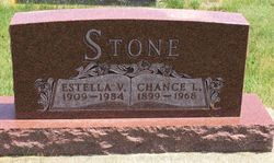
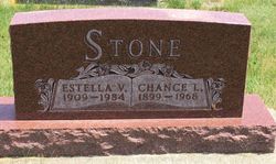
Estella Vera “Stella” Bevers Stone
| Birth | : | 5 Aug 1909 Hamlin County, South Dakota, USA |
| Death | : | 23 Mar 1984 Watertown, Codington County, South Dakota, USA |
| Burial | : | Two Taverns Cemetery, Mount Joy Township, Adams County, USA |
| Coordinate | : | 39.7789000, -77.1676000 |
frequently asked questions (FAQ):
-
Where is Estella Vera “Stella” Bevers Stone's memorial?
Estella Vera “Stella” Bevers Stone's memorial is located at: Two Taverns Cemetery, Mount Joy Township, Adams County, USA.
-
When did Estella Vera “Stella” Bevers Stone death?
Estella Vera “Stella” Bevers Stone death on 23 Mar 1984 in Watertown, Codington County, South Dakota, USA
-
Where are the coordinates of the Estella Vera “Stella” Bevers Stone's memorial?
Latitude: 39.7789000
Longitude: -77.1676000
Family Members:
Parent
Spouse
Siblings
Flowers:
Nearby Cemetories:
1. Two Taverns Cemetery
Mount Joy Township, Adams County, USA
Coordinate: 39.7789000, -77.1676000
2. Saint Mark's Reformed Cemetery
Mount Joy Township, Adams County, USA
Coordinate: 39.7918000, -77.1925000
3. Southern Low Dutch Cemetery
Mount Pleasant Township, Adams County, USA
Coordinate: 39.8068660, -77.1742750
4. Pine Bank Cemetery
Mount Joy Township, Adams County, USA
Coordinate: 39.7761002, -77.2080994
5. Saint Joseph the Worker Catholic Church Cemetery
Bonneauville, Adams County, USA
Coordinate: 39.8106000, -77.1355000
6. Saint Luke's Lutheran Church Cemetery
Mount Pleasant Township, Adams County, USA
Coordinate: 39.8006150, -77.1200140
7. Saint James Reformed Cemetery
Mount Joy Township, Adams County, USA
Coordinate: 39.7312000, -77.1583000
8. Mount Joy Cemetery
Mount Joy Township, Adams County, USA
Coordinate: 39.7479000, -77.2228000
9. Benner Mausoleum
Mount Joy Township, Adams County, USA
Coordinate: 39.7460190, -77.2280750
10. Saint John's Lutheran Cemetery
Germany Township, Adams County, USA
Coordinate: 39.7434000, -77.1030000
11. Evergreen Cemetery
Gettysburg, Adams County, USA
Coordinate: 39.8189011, -77.2305984
12. Gettysburg National Cemetery
Gettysburg, Adams County, USA
Coordinate: 39.8217735, -77.2325592
13. Gettysburg National Military Park
Gettysburg, Adams County, USA
Coordinate: 39.8117332, -77.2442322
14. Mountain View Cemetery
Harney, Carroll County, USA
Coordinate: 39.7196500, -77.2098600
15. Trinity Memorial Garden
Gettysburg, Adams County, USA
Coordinate: 39.8288860, -77.2292220
16. Methodist Episcopal Church Cemetery
Gettysburg, Adams County, USA
Coordinate: 39.8293000, -77.2295000
17. Prince of Peace Episcopal Church Columbarium
Gettysburg, Adams County, USA
Coordinate: 39.8283740, -77.2314500
18. Lincoln Cemetery
Gettysburg, Adams County, USA
Coordinate: 39.8260000, -77.2348000
19. Saint James Lutheran Church Columbarium
Gettysburg, Adams County, USA
Coordinate: 39.8309650, -77.2285840
20. Sunrise Cemetery
Harney, Carroll County, USA
Coordinate: 39.7125015, -77.2031021
21. Mount Carmel Cemetery
Littlestown, Adams County, USA
Coordinate: 39.7397003, -77.0892029
22. Saint Francis Xavier Cemetery
Gettysburg, Adams County, USA
Coordinate: 39.8284290, -77.2385320
23. Salem United Methodist Church Cemetery
Mount Pleasant Township, Adams County, USA
Coordinate: 39.8523540, -77.1423210
24. Piney Creek Church of the Brethren Cemetery
Taneytown, Carroll County, USA
Coordinate: 39.7033005, -77.1536026

