

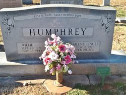
Estelle Ailene Lingle Humphrey - Safrit
| Birth | : | 12 Nov 1925 Salisbury, Rowan County, North Carolina, USA |
| Death | : | 20 Feb 2011 Salisbury, Rowan County, North Carolina, USA |
| Burial | : | Salem Lutheran Church Cemetery, Salisbury, Rowan County, USA |
| Coordinate | : | 35.6871986, -80.5721970 |
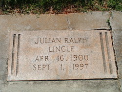
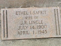
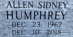
| Description | : | * deceased D/o: * Ethel Irene Safrit & * Julian Ralph Lingle 1st.H: Willie Humphrey 2nd.H: Bruce Safrit Married: 7-20-2011 Children: Cahrles R Humphrey [ Elizabeth Lawrence ] - Allen Humphrey [ Dawn ] - Betty Cauble - Sarah Eckenrod [ Paul ] Grandchildren: Sydney Humphrey - Donald Cauble - Danielle & Alex Eckenrod Great-grandchildren: Milah & Marisa Cauble - Kinsey & Kayden Joihnson Sister: Faye Wiseley O'Bryant [ Tom ] Brothers: Julian Locke Lingle & Luther Voight Lingle [ deceased ] Step-children: Lane Bauka - Jill Clay Step-grandchildren: Cass & Dean Safrit 8 step-great-grandchildren |
frequently asked questions (FAQ):
-
Where is Estelle Ailene Lingle Humphrey - Safrit's memorial?
Estelle Ailene Lingle Humphrey - Safrit's memorial is located at: Salem Lutheran Church Cemetery, Salisbury, Rowan County, USA.
-
When did Estelle Ailene Lingle Humphrey - Safrit death?
Estelle Ailene Lingle Humphrey - Safrit death on 20 Feb 2011 in Salisbury, Rowan County, North Carolina, USA
-
Where are the coordinates of the Estelle Ailene Lingle Humphrey - Safrit's memorial?
Latitude: 35.6871986
Longitude: -80.5721970
Family Members:
Parent
Spouse
Siblings
Children
Flowers:


Nearby Cemetories:
1. Salem Lutheran Church Cemetery
Salisbury, Rowan County, USA
Coordinate: 35.6871986, -80.5721970
2. Sherrills Ford Road Church Cemetery
Salisbury, Rowan County, USA
Coordinate: 35.6884308, -80.5954590
3. Saint Matthew's Episcopal Church Cemetery
Salisbury, Rowan County, USA
Coordinate: 35.7058983, -80.5554962
4. Saint Marks Lutheran Church Cemetery
Salisbury, Rowan County, USA
Coordinate: 35.6541670, -80.5822220
5. Enon Baptist Church Cemetery
Salisbury, Rowan County, USA
Coordinate: 35.7082291, -80.5275421
6. Millers Chapel A.M.E. Zion Church Cemetery
Salisbury, Rowan County, USA
Coordinate: 35.6383470, -80.5717460
7. Gloria Dei Lutheran Church Columbarium
Salisbury, Rowan County, USA
Coordinate: 35.6938358, -80.5110054
8. Owen Family Cemetery
Salisbury, Rowan County, USA
Coordinate: 35.6652985, -80.5159988
9. The Arbor United Methodist Church Cemetery
Salisbury, Rowan County, USA
Coordinate: 35.7356700, -80.5509200
10. Mount Zion Baptist Church
Mount Ulla, Rowan County, USA
Coordinate: 35.6712060, -80.6366480
11. Sacred Heart Roman Catholic Cemetery
Salisbury, Rowan County, USA
Coordinate: 35.7077500, -80.5074440
12. Ebenezer Methodist Church Cemetery
Mount Ulla, Rowan County, USA
Coordinate: 35.6930200, -80.6425900
13. Cedar Grove AME Zion Church Cemetery
Rowan County, USA
Coordinate: 35.7240520, -80.6270450
14. Oakwood Cemetery
Salisbury, Rowan County, USA
Coordinate: 35.6789040, -80.4985750
15. Thyatira Presbyterian Church Cemetery
Mill Bridge, Rowan County, USA
Coordinate: 35.6506310, -80.6371002
16. Salisbury National Cemetery Annex
Salisbury, Rowan County, USA
Coordinate: 35.6879710, -80.4912790
17. Oakdale Union Hill Cemetery
Salisbury, Rowan County, USA
Coordinate: 35.6763130, -80.4905630
18. Franklin Presbyterian Church Cemetery
Franklin, Rowan County, USA
Coordinate: 35.7246880, -80.5032580
19. Lebanon Lutheran Church Cemetery
Cleveland, Rowan County, USA
Coordinate: 35.7402300, -80.6266800
20. Rowan Memorial Park Cemetery
Salisbury, Rowan County, USA
Coordinate: 35.7178001, -80.4955978
21. Second Creek AME Zion - New Birth of Christ Church
Franklin Township, Rowan County, USA
Coordinate: 35.7461100, -80.5252800
22. Grace Lutheran Church Cemetery
China Grove, Rowan County, USA
Coordinate: 35.6180000, -80.5866900
23. Wilhelm Cemetery
Salisbury, Rowan County, USA
Coordinate: 35.6169900, -80.5855170
24. Bethel Lutheran Church Cemetery
Franklin, Rowan County, USA
Coordinate: 35.7212500, -80.4909410