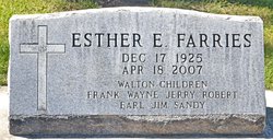
Esther Elizabeth Mary Olson Farries
| Birth | : | 17 Dec 1925 Huron, Beadle County, South Dakota, USA |
| Death | : | 18 Apr 2007 Rapid City, Pennington County, South Dakota, USA |
| Burial | : | Saint Paul's Catholic Cemetery, Belle Fourche, Butte County, USA |
| Coordinate | : | 44.6461000, -103.8667000 |
| Description | : | Esther Elizabeth Mary Farries, 81, of Rapid City and formerly of Pierre, died Wednesday, April 18, 2007 at Rapid City Regional Hospital. She was born Dec. 17, 1925 in Huron, S.D. to Hans Elmer Olson and Lillian Elizabeth (O'Reagan) Olson. She lived there for several years before moving to the Onida and Pierre areas. She has many friends in the Pierre area that she socialized, knew and worked with. She easily made friends wherever she was. Esther was also an active member in the Huron and Pierre Moose Lodges. She moved to Deadwood in 1997 to be closer to family.... Read More |
frequently asked questions (FAQ):
-
Where is Esther Elizabeth Mary Olson Farries's memorial?
Esther Elizabeth Mary Olson Farries's memorial is located at: Saint Paul's Catholic Cemetery, Belle Fourche, Butte County, USA.
-
When did Esther Elizabeth Mary Olson Farries death?
Esther Elizabeth Mary Olson Farries death on 18 Apr 2007 in Rapid City, Pennington County, South Dakota, USA
-
Where are the coordinates of the Esther Elizabeth Mary Olson Farries's memorial?
Latitude: 44.6461000
Longitude: -103.8667000
Family Members:
Parent
Spouse
Siblings
Children
Flowers:
Nearby Cemetories:
1. Saint Paul's Catholic Cemetery
Belle Fourche, Butte County, USA
Coordinate: 44.6461000, -103.8667000
2. Pine Slope Cemetery
Belle Fourche, Butte County, USA
Coordinate: 44.6460991, -103.8666992
3. Riverside Cemetery
Belle Fourche, Butte County, USA
Coordinate: 44.6631012, -103.8636017
4. Minnesela Cemetery
Belle Fourche, Butte County, USA
Coordinate: 44.6549988, -103.8080978
5. Snoma Cemetery
Fruitdale, Butte County, USA
Coordinate: 44.6330986, -103.6844025
6. Gate of Heaven Cemetery
Saint Onge, Lawrence County, USA
Coordinate: 44.5353000, -103.7237000
7. Danish Cemetery
Fruitdale, Butte County, USA
Coordinate: 44.6408005, -103.6485977
8. Rose Hill Cemetery
Spearfish, Lawrence County, USA
Coordinate: 44.4802180, -103.8509270
9. Beulah Cemetery
Beulah, Crook County, USA
Coordinate: 44.5441550, -104.0754550
10. Little Dane Cemetery
Saint Onge, Lawrence County, USA
Coordinate: 44.5252500, -103.6705540
11. Anderson Cemetery
Lawrence County, USA
Coordinate: 44.4747009, -103.6896973
12. Nisland Cemetery
Nisland, Butte County, USA
Coordinate: 44.6769010, -103.5580410
13. Carbonate Cemetery
Maurice, Lawrence County, USA
Coordinate: 44.4000000, -103.8680500
14. Whitewood Cemetery
Whitewood, Lawrence County, USA
Coordinate: 44.4617820, -103.6330030
15. Crook City Cemetery
Crook City, Lawrence County, USA
Coordinate: 44.4432100, -103.6241500
16. Saint Ambrose Cemetery
Deadwood, Lawrence County, USA
Coordinate: 44.3821983, -103.7266998
17. Mount Moriah Cemetery
Deadwood, Lawrence County, USA
Coordinate: 44.3760986, -103.7253036
18. Preston Ghost Town Cemetery
Preston, Lawrence County, USA
Coordinate: 44.3577500, -103.8871670
19. Bear Gulch Cemetery
Lawrence County, USA
Coordinate: 44.3819008, -104.0325012
20. Oak Ridge Cemetery
Deadwood, Lawrence County, USA
Coordinate: 44.3891983, -103.6766968
21. West Lead Cemetery
Lead, Lawrence County, USA
Coordinate: 44.3484001, -103.7779999
22. Beals Cemetery
Vale, Butte County, USA
Coordinate: 44.6185989, -103.4366989
23. South Lead Cemetery
Lead, Lawrence County, USA
Coordinate: 44.3478510, -103.7606260
24. Kimball Family Cemetery
Aladdin, Crook County, USA
Coordinate: 44.7177800, -104.2887700


