
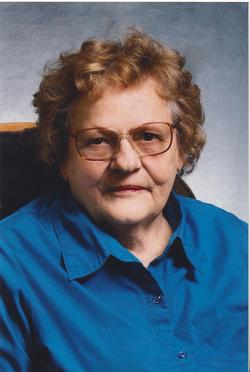
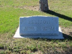
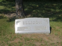
Esther Hintz Ellison
| Birth | : | 9 Sep 1927 Stanton, Mercer County, North Dakota, USA |
| Death | : | 23 Feb 2015 Wolf Point, Roosevelt County, Montana, USA |
| Burial | : | Garrison Cemetery, Garrison, McLean County, USA |
| Coordinate | : | 47.6650000, -101.4201000 |
| Description | : | Esther Ellison, age 87, passed away unexpectedly from a heart attack on February 23, 2015 at Trinity Hospital in Wolf Point, Montana. Esther was born at Stanton, North Dakota on September 9, 1927 to John and Magdelina Hintz. She was raised and went to country school and was the first of the family to graduate from Garrison High School. On October 28, 1945 Dad (Orville) and Mom (Esther) were married. They raised 5 children: Bonnie, Terry, Kelvin, Barbara, and Julie. Mom was a full time housewife and mother. Esther loved to crochet; she made many afghans which she gave as... Read More |
frequently asked questions (FAQ):
-
Where is Esther Hintz Ellison's memorial?
Esther Hintz Ellison's memorial is located at: Garrison Cemetery, Garrison, McLean County, USA.
-
When did Esther Hintz Ellison death?
Esther Hintz Ellison death on 23 Feb 2015 in Wolf Point, Roosevelt County, Montana, USA
-
Where are the coordinates of the Esther Hintz Ellison's memorial?
Latitude: 47.6650000
Longitude: -101.4201000
Family Members:
Parent
Spouse
Siblings

Children
Flowers:


Nearby Cemetories:
1. Garrison Cemetery
Garrison, McLean County, USA
Coordinate: 47.6650000, -101.4201000
2. Saint Nicholas Cemetery
Garrison, McLean County, USA
Coordinate: 47.6469210, -101.3976590
3. Kloestitz German Cemetery
McLean County, USA
Coordinate: 47.6739490, -101.3461250
4. Saint Pauls Cemetery
Garrison, McLean County, USA
Coordinate: 47.6570200, -101.3344940
5. Fort Stevenson Post Cemetery
McLean County, USA
Coordinate: 47.5758800, -101.4453500
6. Saint Pauls Lutheran Cemetery
Douglas Township, McLean County, USA
Coordinate: 47.7476349, -101.4856491
7. Endres Catholic Cemetery
Max, McLean County, USA
Coordinate: 47.7099075, -101.2397003
8. Zion Lutheran Cemetery
Max, McLean County, USA
Coordinate: 47.7653999, -101.2937622
9. Clifton Cemetery
McLean County, USA
Coordinate: 47.7317009, -101.6235962
10. Saint Peter Cemetery
Emmet, McLean County, USA
Coordinate: 47.6742020, -101.6510010
11. Geminde Cemetery
Mercer County, USA
Coordinate: 47.5172005, -101.5061035
12. Saint Johns Congregational Cemetery
Max, McLean County, USA
Coordinate: 47.6871730, -101.1750700
13. Max City Cemetery
Max, McLean County, USA
Coordinate: 47.8127100, -101.2935300
14. Miller Cemetery
Pick City, Mercer County, USA
Coordinate: 47.5018480, -101.5100250
15. Max City Cemetery Old
Max, McLean County, USA
Coordinate: 47.8268088, -101.3014727
16. Evangelical Lutheran Cemetery
Max, McLean County, USA
Coordinate: 47.8268000, -101.3000000
17. Saint Mathew Cemetery
Max, McLean County, USA
Coordinate: 47.7755740, -101.1972780
18. Trinity Mannhaven Cemetery
Pick City, Mercer County, USA
Coordinate: 47.4880260, -101.5064950
19. Immaculate Conception Cemetery
Max, McLean County, USA
Coordinate: 47.8177986, -101.2613983
20. Lilly Dale Cemetery
Emmet, McLean County, USA
Coordinate: 47.5887050, -101.6742500
21. First German Baptist Cemetery
Max, McLean County, USA
Coordinate: 47.6887283, -101.1341629
22. First Baptist Cemetery
Ward County, USA
Coordinate: 47.8484612, -101.2989349
23. Douglas City Cemetery
Douglas, Ward County, USA
Coordinate: 47.8610600, -101.4975100
24. Coleharbor Cemetery
Coleharbor, McLean County, USA
Coordinate: 47.5024986, -101.2369003