
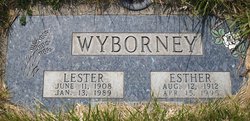
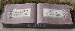
Esther Irene Kunz Wyborney
| Birth | : | 12 Aug 1912 Wilbur, Lincoln County, Washington, USA |
| Death | : | 15 Apr 1995 Wilbur, Lincoln County, Washington, USA |
| Burial | : | Highland Memory Gardens, Mount Washington, Bullitt County, USA |
| Coordinate | : | 38.0625000, -85.5547028 |
| Description | : | d/o Joseph H. Kunz / Mary Miller As a young girl, she lived in Yelm and Soap Lake before returning to Wilbur where she attended school at the Potlatch country school north of Wilbur for the first eight years. She then attended school in Wilbur for three years. Esther and her husband Lester lived and farmed in the Wilbur area until settling in town in the late 1970s. Mrs. Wyborney was a member of the Wilbur Lutheran Church, the Wilbur Senior Citizens, the Rebekah Lodge, the Wilbur Grange and the Grand Coulee Eagles Lodge. She is survived by 1 son, 3... Read More |
frequently asked questions (FAQ):
-
Where is Esther Irene Kunz Wyborney's memorial?
Esther Irene Kunz Wyborney's memorial is located at: Highland Memory Gardens, Mount Washington, Bullitt County, USA.
-
When did Esther Irene Kunz Wyborney death?
Esther Irene Kunz Wyborney death on 15 Apr 1995 in Wilbur, Lincoln County, Washington, USA
-
Where are the coordinates of the Esther Irene Kunz Wyborney's memorial?
Latitude: 38.0625000
Longitude: -85.5547028
Family Members:
Parent

Spouse

Siblings


Children

Flowers:


Nearby Cemetories:
1. Mount Washington Cemetery
Mount Washington, Bullitt County, USA
Coordinate: 38.0503006, -85.5381012
2. Saint Francis Cemetery
Mount Washington, Bullitt County, USA
Coordinate: 38.0489510, -85.5396240
3. Showalter Cemetery
Mount Washington, Bullitt County, USA
Coordinate: 38.0457993, -85.5432968
4. Hall Cemetery
Mount Washington, Bullitt County, USA
Coordinate: 38.0410210, -85.5522600
5. Original Hall Cemetery
Mount Washington, Bullitt County, USA
Coordinate: 38.0389850, -85.5551320
6. Perkins Cemetery
Mount Washington, Bullitt County, USA
Coordinate: 38.0400009, -85.5438995
7. Owens Cemetery
Mount Washington, Bullitt County, USA
Coordinate: 38.0466995, -85.5800018
8. Markwell Cemetery
Mount Washington, Bullitt County, USA
Coordinate: 38.0727997, -85.5224991
9. Newkirk Family Cemetery
Mount Washington, Bullitt County, USA
Coordinate: 38.0226520, -85.5690250
10. Fairmount Cemetery
Fairmount, Jefferson County, USA
Coordinate: 38.1049995, -85.5691986
11. Bethel United Methodist Cemetery
Mount Washington, Bullitt County, USA
Coordinate: 38.0317730, -85.5954080
12. Kings Church Cemetery
Mount Washington, Bullitt County, USA
Coordinate: 38.0740620, -85.4994440
13. Ridgway Cemetery #2
Shepherdsville, Bullitt County, USA
Coordinate: 38.0328800, -85.6054560
14. Gentey Cemetery
Shepherdsville, Bullitt County, USA
Coordinate: 38.0555992, -85.6185989
15. Smith-Hubbs Cemetery
Shepherdsville, Bullitt County, USA
Coordinate: 38.0598850, -85.6311150
16. Grandell Cemetery
Bullitt County, USA
Coordinate: 38.0508003, -85.6352997
17. Ridgway Cemetery #1
Shepherdsville, Bullitt County, USA
Coordinate: 38.0215120, -85.6191220
18. Givhan Cemetery
Shepherdsville, Bullitt County, USA
Coordinate: 38.0211210, -85.6196350
19. Greenwell Cemetery
Shepherdsville, Bullitt County, USA
Coordinate: 37.9959080, -85.5695850
20. Grant Cemetery #2
Shepherdsville, Bullitt County, USA
Coordinate: 38.0507260, -85.6434920
21. Pleasant Grove Cemetery
Shepherdsville, Bullitt County, USA
Coordinate: 38.0202020, -85.6305600
22. Smith Cemetery
Zoneton, Bullitt County, USA
Coordinate: 38.0645800, -85.6499900
23. Seaton Mills Family Cemetery
Seatonville, Jefferson County, USA
Coordinate: 38.1313110, -85.5161290
24. William Swearingen Cemetery
Shepherdsville, Bullitt County, USA
Coordinate: 37.9964430, -85.6020020