
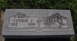

Esther J. Cole
| Birth | : | 1912 |
| Death | : | 1999 |
| Burial | : | All Saints Churchyard, Farmborough, Bath and North East Somerset Unitary Authority, England |
| Coordinate | : | 51.3430620, -2.4876590 |
frequently asked questions (FAQ):
-
Where is Esther J. Cole's memorial?
Esther J. Cole's memorial is located at: All Saints Churchyard, Farmborough, Bath and North East Somerset Unitary Authority, England.
-
When did Esther J. Cole death?
Esther J. Cole death on 1999 in
-
Where are the coordinates of the Esther J. Cole's memorial?
Latitude: 51.3430620
Longitude: -2.4876590
Family Members:
Spouse


Children
Flowers:


Nearby Cemetories:
1. All Saints Churchyard
Farmborough, Bath and North East Somerset Unitary Authority, England
Coordinate: 51.3430620, -2.4876590
2. St. Peter's Church Cemetery
Marksbury, Bath and North East Somerset Unitary Authority, England
Coordinate: 51.3591670, -2.4802780
3. St Mary Church Cemetery
Timsbury, Bath and North East Somerset Unitary Authority, England
Coordinate: 51.3268300, -2.4784070
4. Blessed Virgin Mary Churchyard
Timsbury, Bath and North East Somerset Unitary Authority, England
Coordinate: 51.3257710, -2.4782750
5. Saint Lawrence of Stanton Prior
Keynsham, Bath and North East Somerset Unitary Authority, England
Coordinate: 51.3626830, -2.4638780
6. Saint Lawrence Churchyard
Stanton Prior, Bath and North East Somerset Unitary Authority, England
Coordinate: 51.3627780, -2.4638890
7. Saint Leonard Churchyard
Chelwood, Bath and North East Somerset Unitary Authority, England
Coordinate: 51.3546300, -2.5246880
8. Holy Trinity Churchyard
High Littleton, Bath and North East Somerset Unitary Authority, England
Coordinate: 51.3195810, -2.5115860
9. Saint Luke & Saint Andrew
Priston, Bath and North East Somerset Unitary Authority, England
Coordinate: 51.3419170, -2.4421910
10. Paulton Cemetery
Paulton, Bath and North East Somerset Unitary Authority, England
Coordinate: 51.3095671, -2.4988841
11. St. Peter's Churchyard
Camerton, Bath and North East Somerset Unitary Authority, England
Coordinate: 51.3150300, -2.4503700
12. Church of the Holy Trinity
Paulton, Bath and North East Somerset Unitary Authority, England
Coordinate: 51.3074740, -2.5033500
13. Saint Augustine of Hippo
Clutton, Bath and North East Somerset Unitary Authority, England
Coordinate: 51.3281990, -2.5430220
14. Withyditch Baptist Chapel
Bath, Bath and North East Somerset Unitary Authority, England
Coordinate: 51.3328833, -2.4273859
15. Blessed Virgin Mary Churchyard
Compton Dando, Bath and North East Somerset Unitary Authority, England
Coordinate: 51.3796870, -2.5100920
16. St. John the Baptist Churchyard
Peasedown St John, Bath and North East Somerset Unitary Authority, England
Coordinate: 51.3164630, -2.4327370
17. Saint Michael Churchyard
Keynsham, Bath and North East Somerset Unitary Authority, England
Coordinate: 51.3865690, -2.4830350
18. Holy Trinity Churchyard
Clandown, Bath and North East Somerset Unitary Authority, England
Coordinate: 51.3024050, -2.4611700
19. All Saints Church
Dunkerton, Bath and North East Somerset Unitary Authority, England
Coordinate: 51.3320390, -2.4158600
20. All Saints Churchyard
Publow, Bath and North East Somerset Unitary Authority, England
Coordinate: 51.3751100, -2.5423600
21. Saint Thomas Churchyard
Pensford, Bath and North East Somerset Unitary Authority, England
Coordinate: 51.3710450, -2.5495820
22. St. John the Baptist Churchyard
Farrington Gurney, Bath and North East Somerset Unitary Authority, England
Coordinate: 51.2993710, -2.5248000
23. Pensford Methodist Churchyard
Pensford, Bath and North East Somerset Unitary Authority, England
Coordinate: 51.3731030, -2.5506730
24. Ashgrove Cemetery
Peasedown St John, Bath and North East Somerset Unitary Authority, England
Coordinate: 51.3181600, -2.4150760