
| Birth | : | 4 Apr 1914 Calamus, Clinton County, Iowa, USA |
| Death | : | 21 Mar 1984 Rockford, Winnebago County, Illinois, USA |
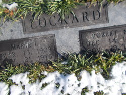
| Burial | : | San Quentin Prison Cemetery, San Rafael, Marin County, USA |
| Coordinate | : | 37.9436480, -122.4883760 |
| Description | : | Wife of Eugene Anderson. Daughter of Amos A. and Mable C. (Henry) Chase |
frequently asked questions (FAQ):
-
Where is Esther Lorraine Chase Anderson's memorial?
Esther Lorraine Chase Anderson's memorial is located at: San Quentin Prison Cemetery, San Rafael, Marin County, USA.
-
When did Esther Lorraine Chase Anderson death?
Esther Lorraine Chase Anderson death on 21 Mar 1984 in Rockford, Winnebago County, Illinois, USA
-
Where are the coordinates of the Esther Lorraine Chase Anderson's memorial?
Latitude: 37.9436480
Longitude: -122.4883760
Family Members:
Parent

Siblings
Children
Flowers:


Nearby Cemetories:
1. San Quentin Prison Cemetery
San Rafael, Marin County, USA
Coordinate: 37.9436480, -122.4883760
2. Mission San Rafael Arcangel Cemetery
San Rafael, Marin County, USA
Coordinate: 37.9744330, -122.5280570
3. Montgomery Memorial Chapel Crypt
San Anselmo, Marin County, USA
Coordinate: 37.9687940, -122.5638630
4. Mount Tamalpais Cemetery
San Rafael, Marin County, USA
Coordinate: 37.9861984, -122.5544891
5. First Presbyterian Church Memorial Garden
San Anselmo, Marin County, USA
Coordinate: 37.9703310, -122.5667860
6. St. Stephen's Episcopal Church Memorial Garden
Belvedere, Marin County, USA
Coordinate: 37.8767515, -122.4712901
7. Mount Olivet Catholic Cemetery
San Rafael, Marin County, USA
Coordinate: 38.0024986, -122.5397034
8. Fernwood Cemetery
Mill Valley, Marin County, USA
Coordinate: 37.8767014, -122.5231018
9. Druid Heights Burial Site
Mill Valley, Marin County, USA
Coordinate: 37.8892100, -122.5647100
10. Angel Island Cemetery (defunct)
Tiburon, Marin County, USA
Coordinate: 37.8621830, -122.4325920
11. Saint Vincents Orphanage Cemetery
San Rafael, Marin County, USA
Coordinate: 38.0355800, -122.5334550
12. Sailors Cemetery
Sausalito, Marin County, USA
Coordinate: 37.8442390, -122.4774770
13. Marin County Farm Cemetery
Marin County, USA
Coordinate: 38.0285500, -122.5652530
14. Saint Pauls Cemetery (Defunct)
San Pablo, Contra Costa County, USA
Coordinate: 37.9563332, -122.3430099
15. Salesian Cemetery
Richmond, Contra Costa County, USA
Coordinate: 37.9532650, -122.3401230
16. Saint Joseph Catholic Cemetery
San Pablo, Contra Costa County, USA
Coordinate: 37.9612700, -122.3336600
17. Rolling Hills Memorial Park
Richmond, Contra Costa County, USA
Coordinate: 37.9756012, -122.3146973
18. Presidio of San Francisco Pet Cemetery
San Francisco, San Francisco County, USA
Coordinate: 37.8025490, -122.4671960
19. San Francisco National Cemetery
San Francisco, San Francisco County, USA
Coordinate: 37.8011208, -122.4617462
20. World War II West Coast Memorial
San Francisco, San Francisco County, USA
Coordinate: 37.7941742, -122.4653168
21. Golden Gate Fields
Albany, Alameda County, USA
Coordinate: 37.8854000, -122.3117000
22. Saint Mary's Columbarium
San Francisco, San Francisco County, USA
Coordinate: 37.7965330, -122.4376000
23. Hebrew Cemetery (Defunct)
San Francisco, San Francisco County, USA
Coordinate: 37.7959320, -122.4261060
24. Caledonian Cemetery (Defunct)
San Francisco, San Francisco County, USA
Coordinate: 37.7857070, -122.4958030