
| Memorials | : | 6 |
| Location | : | San Rafael, Marin County, USA |
| Coordinate | : | 37.9744330, -122.5280570 |
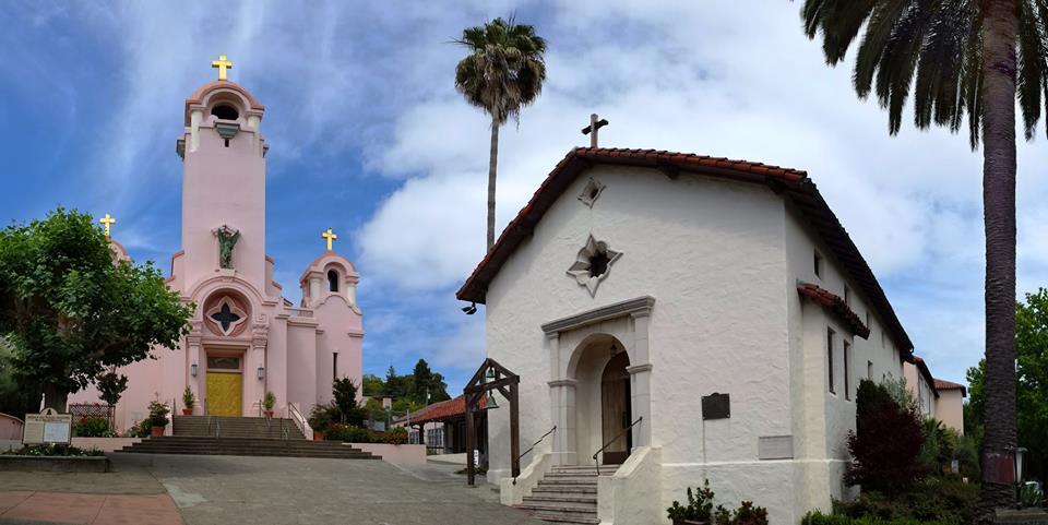
| Description | : | Mission San Rafael Arcangel, the 20th of the California missions, was established as a helper, or asistencia, to Mission Dolores in December 1817. Mission San Rafael was the first mission to be secularized in 1834. The chapel became the parish church for Mexican ranchers. The cemetery was the last active part of the old mission and served as a final resting place for Native American Indians and others, including Chief Marin and Fr. Juan Amoros. [from http://www.saintraphael.com] No signs of the cemetery remains. |
frequently asked questions (FAQ):
-
Where is Mission San Rafael Arcangel Cemetery?
Mission San Rafael Arcangel Cemetery is located at San Rafael, Marin County ,California ,USA.
-
Mission San Rafael Arcangel Cemetery cemetery's updated grave count on graveviews.com?
6 memorials
-
Where are the coordinates of the Mission San Rafael Arcangel Cemetery?
Latitude: 37.9744330
Longitude: -122.5280570
Nearby Cemetories:
1. Mount Tamalpais Cemetery
San Rafael, Marin County, USA
Coordinate: 37.9861984, -122.5544891
2. Montgomery Memorial Chapel Crypt
San Anselmo, Marin County, USA
Coordinate: 37.9687940, -122.5638630
3. Mount Olivet Catholic Cemetery
San Rafael, Marin County, USA
Coordinate: 38.0024986, -122.5397034
4. First Presbyterian Church Memorial Garden
San Anselmo, Marin County, USA
Coordinate: 37.9703310, -122.5667860
5. San Quentin Prison Cemetery
San Rafael, Marin County, USA
Coordinate: 37.9436480, -122.4883760
6. Saint Vincents Orphanage Cemetery
San Rafael, Marin County, USA
Coordinate: 38.0355800, -122.5334550
7. Marin County Farm Cemetery
Marin County, USA
Coordinate: 38.0285500, -122.5652530
8. Druid Heights Burial Site
Mill Valley, Marin County, USA
Coordinate: 37.8892100, -122.5647100
9. Fernwood Cemetery
Mill Valley, Marin County, USA
Coordinate: 37.8767014, -122.5231018
10. St. Stephen's Episcopal Church Memorial Garden
Belvedere, Marin County, USA
Coordinate: 37.8767515, -122.4712901
11. Angel Island Cemetery (defunct)
Tiburon, Marin County, USA
Coordinate: 37.8621830, -122.4325920
12. Sailors Cemetery
Sausalito, Marin County, USA
Coordinate: 37.8442390, -122.4774770
13. Saint Mary Magdalene Catholic Church Cemetery
Bolinas, Marin County, USA
Coordinate: 37.9212570, -122.6938858
14. Bolinas Cemetery
Bolinas, Marin County, USA
Coordinate: 37.9212600, -122.6938900
15. Valley Memorial Park
Novato, Marin County, USA
Coordinate: 38.1204300, -122.5436300
16. Saint Pauls Cemetery (Defunct)
San Pablo, Contra Costa County, USA
Coordinate: 37.9563332, -122.3430099
17. Pioneer Memorial Cemetery
Novato, Marin County, USA
Coordinate: 38.1132532, -122.5902599
18. Salesian Cemetery
Richmond, Contra Costa County, USA
Coordinate: 37.9532650, -122.3401230
19. Saint Joseph Catholic Cemetery
San Pablo, Contra Costa County, USA
Coordinate: 37.9612700, -122.3336600
20. Rolling Hills Memorial Park
Richmond, Contra Costa County, USA
Coordinate: 37.9756012, -122.3146973
21. Taylor Cemetery
Lagunitas, Marin County, USA
Coordinate: 38.0272580, -122.7346590
22. Presidio of San Francisco Pet Cemetery
San Francisco, San Francisco County, USA
Coordinate: 37.8025490, -122.4671960
23. San Francisco National Cemetery
San Francisco, San Francisco County, USA
Coordinate: 37.8011208, -122.4617462
24. World War II West Coast Memorial
San Francisco, San Francisco County, USA
Coordinate: 37.7941742, -122.4653168