
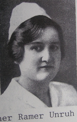

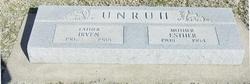

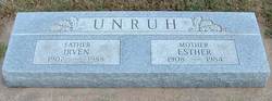
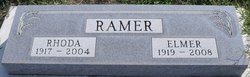
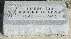
Esther Mae Ramer Unruh
| Birth | : | 30 Jan 1908 Port Trevorton, Snyder County, Pennsylvania, USA |
| Death | : | 22 Nov 1984 Harper, Harper County, Kansas, USA |
| Burial | : | Shell Church Cemetery, Canterbury, Merrimack County, USA |
| Coordinate | : | 43.3636640, -71.5137790 |
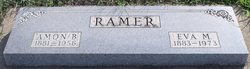
| Description | : | Esther died Thanksgiving Day, Nov. 22, 1984, at Harper Hospital. She was married to Irven Unruh in 1933. She was born Jan. 30, 1908 in a farm house on top of a mountain near Port Trevorton, Penn. Her parents were Ammon B. and Kathryn (Flanders) Ramer. Her mother died when she was 4 years old. Her father married Eva Shellenberger in Harper 2 years later. While in her early teens the family moved to the raw prairies of Alberta, Canada, near Duchess. When she was 19, she went to La Junta, Colorado, to enroll in the Mennonite School of Nursing.... Read More |
frequently asked questions (FAQ):
-
Where is Esther Mae Ramer Unruh's memorial?
Esther Mae Ramer Unruh's memorial is located at: Shell Church Cemetery, Canterbury, Merrimack County, USA.
-
When did Esther Mae Ramer Unruh death?
Esther Mae Ramer Unruh death on 22 Nov 1984 in Harper, Harper County, Kansas, USA
-
Where are the coordinates of the Esther Mae Ramer Unruh's memorial?
Latitude: 43.3636640
Longitude: -71.5137790
Family Members:
Parent
Spouse
Siblings
Children

Flowers:


Nearby Cemetories:
1. Shell Church Cemetery
Canterbury, Merrimack County, USA
Coordinate: 43.3636640, -71.5137790
2. Shaker Cemetery
Canterbury, Merrimack County, USA
Coordinate: 43.3621930, -71.4901830
3. Ham Cemetery
Canterbury, Merrimack County, USA
Coordinate: 43.3755989, -71.4942017
4. Baptist Old Cemetery
Canterbury, Merrimack County, USA
Coordinate: 43.3448320, -71.5098800
5. Maple Grove Cemetery
Canterbury, Merrimack County, USA
Coordinate: 43.3449500, -71.5077600
6. Ham Cemetery
Canterbury, Merrimack County, USA
Coordinate: 43.3816100, -71.4918600
7. Cogswell Family Cemetery
Canterbury, Merrimack County, USA
Coordinate: 43.3838270, -71.4955690
8. Mathes Cemetery
Canterbury, Merrimack County, USA
Coordinate: 43.3894440, -71.5119440
9. Miles Smith Cemetery
Loudon, Merrimack County, USA
Coordinate: 43.3412900, -71.4835100
10. Hills Corner Cemetery
Canterbury, Merrimack County, USA
Coordinate: 43.3926000, -71.4958000
11. Cate Cemetery
Loudon, Merrimack County, USA
Coordinate: 43.3532410, -71.4715490
12. Lougee Cemetery
Loudon, Merrimack County, USA
Coordinate: 43.3524400, -71.4717270
13. Bean Hill Burying Ground
Canterbury, Merrimack County, USA
Coordinate: 43.3963890, -71.5094440
14. Blaisdell Graveyard
Loudon, Merrimack County, USA
Coordinate: 43.3457800, -71.4700840
15. Pearl Cemetery
Loudon, Merrimack County, USA
Coordinate: 43.3415260, -71.4695400
16. Hill Graveyard
Loudon, Merrimack County, USA
Coordinate: 43.3321150, -71.4775470
17. Cate Cemetery
Loudon, Merrimack County, USA
Coordinate: 43.3461110, -71.4577780
18. Cilley Cemetery
Northfield, Merrimack County, USA
Coordinate: 43.4070587, -71.5289993
19. Huntoon Cemetery
Canterbury, Merrimack County, USA
Coordinate: 43.3989170, -71.4744440
20. Canterbury Village Cemetery
Canterbury, Merrimack County, USA
Coordinate: 43.3371220, -71.5648240
21. Osgoodite Cemetery
Canterbury, Merrimack County, USA
Coordinate: 43.3368660, -71.5650340
22. Lyford Cemetery
Canterbury, Merrimack County, USA
Coordinate: 43.4048290, -71.4856770
23. Hill Cemetery
Loudon, Merrimack County, USA
Coordinate: 43.3270200, -71.4755270
24. Clark-Evans Cemetery
Northfield, Merrimack County, USA
Coordinate: 43.4096222, -71.5311584