
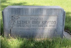
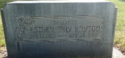
Esther May Kayton
| Birth | : | 12 Apr 1925 Sheridan County, Nebraska, USA |
| Death | : | 28 Nov 1959 Norfolk, Madison County, Nebraska, USA |
| Burial | : | Gordon Cemetery, Gordon, Sheridan County, USA |
| Coordinate | : | 42.7858009, -102.2102966 |
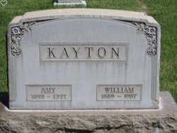
| Description | : | Esther May Kayton was born April 12, 1925 to William and Amy Carr Kayton at Gordon, Nebraska and died November 28, 1959 at Norfolk, Nebraska, at the age of 34 years, seven months and 16 days. Esther grew to womanhood in the Gordon area and attended the Gordon public schools. For the past 15 years of her life she suffered a good deal with various afflictions and has been confined to home much more than the average person. She told a nurse recently that "God surely has been good to me" and often quoted the 23rd... Read More |
frequently asked questions (FAQ):
-
Where is Esther May Kayton's memorial?
Esther May Kayton's memorial is located at: Gordon Cemetery, Gordon, Sheridan County, USA.
-
When did Esther May Kayton death?
Esther May Kayton death on 28 Nov 1959 in Norfolk, Madison County, Nebraska, USA
-
Where are the coordinates of the Esther May Kayton's memorial?
Latitude: 42.7858009
Longitude: -102.2102966
Family Members:
Parent

Siblings

Flowers:


Nearby Cemetories:
1. Gordon Cemetery
Gordon, Sheridan County, USA
Coordinate: 42.7858009, -102.2102966
2. Mount Hope Cemetery
Gordon, Sheridan County, USA
Coordinate: 42.7113991, -102.2241974
3. Dane Cemetery
Cherry County, USA
Coordinate: 42.7924300, -102.0824700
4. Bethel Cemetery
Sheridan County, USA
Coordinate: 42.9011002, -102.3208008
5. Lavaca Cemetery
Irwin, Cherry County, USA
Coordinate: 42.7332993, -102.0175018
6. Amity Cemetery
Sheridan County, USA
Coordinate: 42.8036003, -102.4389038
7. Fair View Cemetery
Rushville, Sheridan County, USA
Coordinate: 42.7155991, -102.4325027
8. Saint Aloysius Cemetery
Sheridan County, USA
Coordinate: 42.9015500, -102.4025500
9. Saint Marys Cemetery
Rushville, Sheridan County, USA
Coordinate: 42.7174988, -102.4436035
10. Feather on Head Cemetery
Oglala Lakota County, USA
Coordinate: 43.0311012, -102.1611023
11. Holly Cemetery
Rushville, Sheridan County, USA
Coordinate: 42.8575120, -102.5370990
12. Novotny Cemetery
Hay Springs, Sheridan County, USA
Coordinate: 42.7742004, -102.5963974
13. Davis Cemetery
Rushville, Sheridan County, USA
Coordinate: 42.5421000, -102.4118800
14. Wolf Creek Community Cemetery
Oglala Lakota County, USA
Coordinate: 43.0405750, -102.3966490
15. Spotted Bear Family Cemetery
Denby, Oglala Lakota County, USA
Coordinate: 43.0608200, -102.3376600
16. Preble Cemetery
Sheridan County, USA
Coordinate: 42.6504000, -102.5765000
17. Abold Family Cemetery
Rushville, Sheridan County, USA
Coordinate: 42.8863500, -102.6158000
18. Bomar Cemetery
Hay Springs, Sheridan County, USA
Coordinate: 42.8062000, -102.6459600
19. Native American Cemetery
Oglala, Oglala Lakota County, USA
Coordinate: 43.0886002, -102.3550034
20. White Clay Cemetery
Rushville, Sheridan County, USA
Coordinate: 42.9732820, -102.5667230
21. Knight Cemetery
Oglala Lakota County, USA
Coordinate: 43.1039009, -102.1200027
22. Holy Cross Cemetery
Pine Ridge, Oglala Lakota County, USA
Coordinate: 43.0194016, -102.5503006
23. Pine Ridge Presbyterian Cemetery
Pine Ridge, Oglala Lakota County, USA
Coordinate: 43.0235200, -102.5506200
24. Beguin Cemetery
Sheridan County, USA
Coordinate: 42.5107994, -102.4982986