
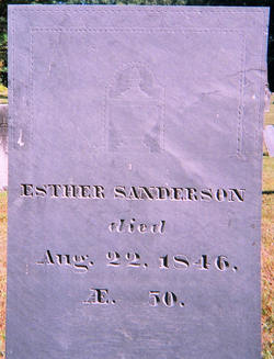
Esther Sanderson
| Birth | : | 19 Oct 1796 Massachusetts, USA |
| Death | : | 22 Aug 1846 Massachusetts, USA |
| Burial | : | Curlee Cemetery, Cannon County, USA |
| Coordinate | : | 35.7799988, -86.1631012 |
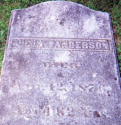
| Inscription | : | Esther Sanderson died Aug 22 1846 AE 50 |
| Description | : | 2nd Esther of Asa & Lucy (Scott) Sanderson |
frequently asked questions (FAQ):
-
Where is Esther Sanderson's memorial?
Esther Sanderson's memorial is located at: Curlee Cemetery, Cannon County, USA.
-
When did Esther Sanderson death?
Esther Sanderson death on 22 Aug 1846 in Massachusetts, USA
-
Where are the coordinates of the Esther Sanderson's memorial?
Latitude: 35.7799988
Longitude: -86.1631012
Family Members:
Parent
Siblings

Flowers:


Nearby Cemetories:
1. Curlee Cemetery
Cannon County, USA
Coordinate: 35.7799988, -86.1631012
2. Lassiter Cemetery
Cannon County, USA
Coordinate: 35.7811012, -86.1755981
3. Cannon County Farm Cemetery
Cannon County, USA
Coordinate: 35.7897890, -86.1522920
4. Brandon Cemetery
Cannon County, USA
Coordinate: 35.7891998, -86.1453018
5. Cateston Cemetery
Cannon County, USA
Coordinate: 35.7966995, -86.1511002
6. Simpson Cemetery
Cannon County, USA
Coordinate: 35.7792015, -86.1350021
7. Brawleys Fork Cemetery
Readyville, Cannon County, USA
Coordinate: 35.8038902, -86.1524963
8. Saffel Cemetery
Cannon County, USA
Coordinate: 35.8067017, -86.1605988
9. Davis-Thomas Cemetery
Cannon County, USA
Coordinate: 35.7691994, -86.1324997
10. Hoover Cemetery
Rutherford County, USA
Coordinate: 35.8025017, -86.1819000
11. Gandy Cemetery
Cannon County, USA
Coordinate: 35.8058014, -86.1382980
12. Pallette Cemetery
Cannon County, USA
Coordinate: 35.7481003, -86.1722031
13. Barton Cemetery
Cannon County, USA
Coordinate: 35.8111000, -86.1500015
14. Patton Cemetery
Cannon County, USA
Coordinate: 35.7430992, -86.1541977
15. Cripple Creek Cemetery
Floraton, Rutherford County, USA
Coordinate: 35.7783012, -86.2133026
16. Bragg Cemetery
Cannon County, USA
Coordinate: 35.8191986, -86.1346970
17. Francis Youree Cemetery
Rutherford County, USA
Coordinate: 35.7724991, -86.2197037
18. Jones Cemetery
Rutherford County, USA
Coordinate: 35.8231010, -86.1875000
19. Milligan Cemetery
Cannon County, USA
Coordinate: 35.7386017, -86.1231003
20. Jameson Cemetery
Cannon County, USA
Coordinate: 35.7542000, -86.1053009
21. Carter Cemetery
Cannon County, USA
Coordinate: 35.8314018, -86.1389008
22. Herrod Cemetery
Rutherford County, USA
Coordinate: 35.7907982, -86.2324982
23. Donnell Chapel
Donnell Chapel, Rutherford County, USA
Coordinate: 35.7464350, -86.2208420
24. Herrod Cemetery
Rutherford County, USA
Coordinate: 35.8097000, -86.2256012