

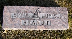
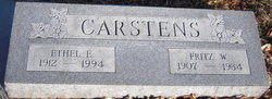
Ethel E. Brandt Carstens
| Birth | : | 1912 Nebraska, USA |
| Death | : | 1994 |
| Burial | : | Fairview Cemetery, Franklin County, USA |
| Coordinate | : | 44.7196999, -74.5599976 |
frequently asked questions (FAQ):
-
Where is Ethel E. Brandt Carstens's memorial?
Ethel E. Brandt Carstens's memorial is located at: Fairview Cemetery, Franklin County, USA.
-
When did Ethel E. Brandt Carstens death?
Ethel E. Brandt Carstens death on 1994 in
-
Where are the coordinates of the Ethel E. Brandt Carstens's memorial?
Latitude: 44.7196999
Longitude: -74.5599976
Family Members:
Parent

Spouse
Siblings

Flowers:


Nearby Cemetories:
1. Fairview Cemetery
Franklin County, USA
Coordinate: 44.7196999, -74.5599976
2. Ives Cemetery
Dickinson Center, Franklin County, USA
Coordinate: 44.7164001, -74.5496979
3. Palmer Cemetery
Dickinson, Franklin County, USA
Coordinate: 44.7118100, -74.5790900
4. Pot Hook Hill Cemetery
Dickinson, Franklin County, USA
Coordinate: 44.6865667, -74.5234333
5. North Dickinson Cemetery
Dickinson, Franklin County, USA
Coordinate: 44.7656350, -74.5701560
6. Saint Ann's Cemetery
Saint Regis Falls, Franklin County, USA
Coordinate: 44.6761017, -74.5263977
7. Forest Cemetery
Saint Regis Falls, Franklin County, USA
Coordinate: 44.6749992, -74.5261002
8. East Dickinson Cemetery
East Dickinson, Franklin County, USA
Coordinate: 44.7710700, -74.5165200
9. Mound Hill Cemetery
Nicholville, St. Lawrence County, USA
Coordinate: 44.6977997, -74.6505966
10. Saint Therese Cemetery
Nicholville, St. Lawrence County, USA
Coordinate: 44.7033310, -74.6590500
11. Chesterfield Cemetery
Lawrenceville, St. Lawrence County, USA
Coordinate: 44.7447014, -74.6669006
12. Hill Crest Cemetery
Lawrenceville, St. Lawrence County, USA
Coordinate: 44.7872009, -74.6477966
13. Moira Community Cemetery
Moira, Franklin County, USA
Coordinate: 44.8184900, -74.5598900
14. Holy Cross Cemetery
Hopkinton, St. Lawrence County, USA
Coordinate: 44.6777992, -74.6958008
15. Saint Marys Cemetery
Brushton, Franklin County, USA
Coordinate: 44.8232994, -74.5224991
16. Fort Jackson Hopkinton Cemetery
Hopkinton, St. Lawrence County, USA
Coordinate: 44.6996994, -74.7089005
17. Saint Peters Cemetery
Brushton, Franklin County, USA
Coordinate: 44.8244019, -74.5216980
18. Maple Grove Cemetery
North Lawrence, St. Lawrence County, USA
Coordinate: 44.7912598, -74.6753693
19. Haleville Cemetery
Stockholm Center, St. Lawrence County, USA
Coordinate: 44.7736015, -74.6932983
20. Santa Clara Cemetery
Santa Clara, Franklin County, USA
Coordinate: 44.6346512, -74.4638977
21. Saint Lawrence Cemetery
North Lawrence, St. Lawrence County, USA
Coordinate: 44.7920227, -74.6754761
22. Sunnyside Cemetery
Brushton, Franklin County, USA
Coordinate: 44.8272018, -74.5222015
23. West Bangor Cemetery
Bangor, Franklin County, USA
Coordinate: 44.8011100, -74.4466800
24. Develin Cemetery
Franklin County, USA
Coordinate: 44.8022003, -74.4467010