
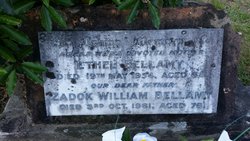
Ethel Pogson Bellamy
| Birth | : | 27 Jan 1886 Pennant Hills, Hornsby Shire, New South Wales, Australia |
| Death | : | 19 May 1954 Pennant Hills, Hornsby Shire, New South Wales, Australia |
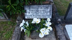
| Burial | : | Macquarie Park Cemetery and Crematorium, North Ryde, Ryde City, Australia |
| Coordinate | : | -33.7937180, 151.1420060 |
| Plot | : | Methodist Mounumental, Section D8, Position 0011 |
| Description | : | Death Notice BELLAMY, Ethel.— May 19, 1954, at her residence, 355 Pennant Hills Road, Pennant Hills, dearly loved wife of Zadok Bellamy, and loved mother of Geoffrey, Irene (Mrs. C. Kirkwood), Valerie (Mrs. J. Wood), Dudley, and Clive, aged 68 years. For funeral notice see Friday's "Herald." Source: Sydney Morning Herald (NSW : 1842 - 1954), Thursday 20 May 1954, page 20 Funeral Notice BELLAMY - The Relatives and Friends of the late ETHEL BELLAMY of 355 Pennant Hills Road, Pennant Hills, are kindly Invited to attend her Funeral to leave the Chapel of Motor... Read More |
frequently asked questions (FAQ):
-
Where is Ethel Pogson Bellamy's memorial?
Ethel Pogson Bellamy's memorial is located at: Macquarie Park Cemetery and Crematorium, North Ryde, Ryde City, Australia.
-
When did Ethel Pogson Bellamy death?
Ethel Pogson Bellamy death on 19 May 1954 in Pennant Hills, Hornsby Shire, New South Wales, Australia
-
Where are the coordinates of the Ethel Pogson Bellamy's memorial?
Latitude: -33.7937180
Longitude: 151.1420060
Family Members:
Parent

Spouse

Siblings

Children
Flowers:


Nearby Cemetories:
1. Macquarie Park Cemetery and Crematorium
North Ryde, Ryde City, Australia
Coordinate: -33.7937180, 151.1420060
2. Northern Suburbs Memorial Gardens and Crematorium
North Ryde, Ryde City, Australia
Coordinate: -33.7954460, 151.1511550
3. Field of Mars Cemetery
East Ryde, Ryde City, Australia
Coordinate: -33.8120030, 151.1246480
4. Ryde Baptist Graveyard
Ryde, Ryde City, Australia
Coordinate: -33.8062930, 151.1119180
5. St Charles Borromeo Cemetery
Ryde, Ryde City, Australia
Coordinate: -33.8188360, 151.1146200
6. St. John's Anglican Church Cemetery
Gordon, Ku-ring-gai Council, Australia
Coordinate: -33.7571060, 151.1519580
7. Saint Annes Church Cemetery
Ryde, Ryde City, Australia
Coordinate: -33.8156960, 151.1042650
8. Church of St. Francis and St. Alban
Gordon, Ku-ring-gai Council, Australia
Coordinate: -33.7563700, 151.1522220
9. St Aidan's Anglican Church
Longueville, Lane Cove Municipality, Australia
Coordinate: -33.8281510, 151.1709560
10. Gladesville Asylum Cemetery
Gladesville, Hunter's Hill Municipality, Australia
Coordinate: -33.8393010, 151.1342490
11. Gore Hill Cemetery
St Leonards, North Sydney Council, Australia
Coordinate: -33.8229500, 151.1887590
12. St. Thomas Rest Park
Crows Nest, North Sydney Council, Australia
Coordinate: -33.8244490, 151.2063050
13. Mary MacKillop Memorial Chapel
North Sydney, North Sydney Council, Australia
Coordinate: -33.8388250, 151.2049160
14. Carlingford Anglican Cemetery
Carlingford, City of Parramatta Council, Australia
Coordinate: -33.7833430, 151.0598510
15. Frenchs Forest Cemetery
Davidson, Northern Beaches Council, Australia
Coordinate: -33.7392360, 151.2020750
16. Longbottom Cemetery
Concord, Canada Bay City, Australia
Coordinate: -33.8596140, 151.0986280
17. St. Luke's Anglican Church Columbarium
Concord, Canada Bay City, Australia
Coordinate: -33.8678417, 151.1068448
18. St. Mary's Roman Catholic Church Cemetery
Concord, Canada Bay City, Australia
Coordinate: -33.8677100, 151.1024300
19. Pioneers Memorial Park
Leichhardt, Inner West Council, Australia
Coordinate: -33.8780800, 151.1575000
20. Balmain Catholic Cemetery (Defunct)
Leichhardt, Inner West Council, Australia
Coordinate: -33.8797270, 151.1523730
21. St David’s Presbyterian Cemetery
Haberfield, Inner West Council, Australia
Coordinate: -33.8823220, 151.1378500
22. St. John's Anglican Church Cemetery
Ashfield, Inner West Council, Australia
Coordinate: -33.8817160, 151.1278730
23. St Paul's Anglican Church
Burwood, Burwood Municipality, Australia
Coordinate: -33.8816114, 151.1027492
24. Royal Botanic Gardens
Sydney, City of Sydney, Australia
Coordinate: -33.8647440, 151.2170610