
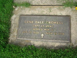

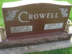
Eugene Dale “Gene” Crowell
| Birth | : | 15 Jun 1920 Rockford, Floyd County, Iowa, USA |
| Death | : | 25 Nov 1998 Rockford, Floyd County, Iowa, USA |
| Burial | : | Riverside Cemetery, Rockford, Floyd County, USA |
| Coordinate | : | 43.0578003, -92.9464035 |
| Plot | : | Section 15 |
| Description | : | Eugene Dale "Gene" Crowell – June 15, 1920 – November 25, 1998 MASON CITY — Gene Crowell, 78, of 380 Yorktown Pike, died Wednesday (Nov. 25, 1998) at his residence. A funeral mass will be held at 10:30 a.m. today, Nov. 28, 1998 at Holy Name Catholic Church, Rockford with the Rev. Dennis Cahill officiating. Interment will follow in the Riverside Cemetery, Rockford. Military rites will be performed by the Walker-Graper Post, American Legion. Visitation will be held from 8 a.m. until 10 a.m. today at Fullerton Schumburg Funeral Home, 302 W Main, Rockford. Those planning an expression of sympathy may direct memorials... Read More |
frequently asked questions (FAQ):
-
Where is Eugene Dale “Gene” Crowell's memorial?
Eugene Dale “Gene” Crowell's memorial is located at: Riverside Cemetery, Rockford, Floyd County, USA.
-
When did Eugene Dale “Gene” Crowell death?
Eugene Dale “Gene” Crowell death on 25 Nov 1998 in Rockford, Floyd County, Iowa, USA
-
Where are the coordinates of the Eugene Dale “Gene” Crowell's memorial?
Latitude: 43.0578003
Longitude: -92.9464035
Family Members:
Parent


Spouse

Siblings
Children

Flowers:


Nearby Cemetories:
1. Riverside Cemetery
Rockford, Floyd County, USA
Coordinate: 43.0578003, -92.9464035
2. Ulsterville Cemetery
Ulster Township, Floyd County, USA
Coordinate: 43.0936012, -92.8842010
3. Flood Creek Cemetery
Floyd County, USA
Coordinate: 43.0391998, -92.8538971
4. Rock Grove Township Cemetery
Nora Springs, Floyd County, USA
Coordinate: 43.1227989, -92.9880981
5. Rudd Evergreen Cemetery
Rudd, Floyd County, USA
Coordinate: 43.1417007, -92.9214020
6. Park Cemetery
Nora Springs, Floyd County, USA
Coordinate: 43.1444016, -92.9982986
7. Saint Marys Catholic Cemetery
Roseville, Floyd County, USA
Coordinate: 43.0090000, -92.8134000
8. West Saint Charles United Methodist Cemetery
Floyd County, USA
Coordinate: 43.0580597, -92.7897186
9. Westside Cemetery
Marble Rock, Floyd County, USA
Coordinate: 42.9556007, -92.8739014
10. Hillside Cemetery
Marble Rock, Floyd County, USA
Coordinate: 42.9583015, -92.8666992
11. Spring Grove Cemetery
Nora Springs, Floyd County, USA
Coordinate: 43.1631012, -93.0211029
12. Owens Grove Cemetery
Cerro Gordo County, USA
Coordinate: 43.0825005, -93.1144180
13. Saint Patricks Catholic Cemetery
Dougherty, Cerro Gordo County, USA
Coordinate: 42.9227791, -93.0294418
14. Eden Presbyterian Cemetery
Meroa, Mitchell County, USA
Coordinate: 43.2131004, -92.9103012
15. West End Cemetery
Meroa, Mitchell County, USA
Coordinate: 43.2216682, -92.9250031
16. Oakwood Cemetery
Floyd, Floyd County, USA
Coordinate: 43.1178017, -92.7307968
17. Dudley Cemetery
Dudley (historical), Mitchell County, USA
Coordinate: 43.2252998, -92.8743973
18. Rock Creek Cemetery
Meroa, Mitchell County, USA
Coordinate: 43.2352791, -92.9225006
19. Halls Grove Cemetery
Greene, Butler County, USA
Coordinate: 42.8840100, -92.8782300
20. Rock Falls Cemetery
Rock Falls, Cerro Gordo County, USA
Coordinate: 43.2122192, -93.0858307
21. Pleasant Grove Cemetery
Powersville, Floyd County, USA
Coordinate: 42.9441986, -92.7446976
22. Calvary Cemetery
Osage, Mitchell County, USA
Coordinate: 43.2238998, -92.8300018
23. Riverside Cemetery
Charles City, Floyd County, USA
Coordinate: 43.0766983, -92.6881027
24. West Fork Cemetery
Franklin County, USA
Coordinate: 42.8918991, -93.0836029