

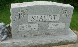
Linda Jean “GL” Crowell Staudt
| Birth | : | 10 Oct 1943 Macon, Bibb County, Georgia, USA |
| Death | : | 9 Apr 2022 Mason City, Cerro Gordo County, Iowa, USA |
| Burial | : | Saint Marys Catholic Cemetery, Roseville, Floyd County, USA |
| Coordinate | : | 43.0090000, -92.8134000 |
| Description | : | Linda J. Staudt, 78, "GL" passed away Saturday, April 9, 2022 at the IOOF Home in Mason City after battling with the complications of cancer. Mass of Christian Burial will be held 10:30 a.m. Wednesday, April 13, 2022 at Epiphany Parish – Holy Family Catholic Church, 722 North Adams Street, Mason City, IA with Rev. Neil Manternach, celebrant. She will be laid to rest beside her husband at St. Mary's Catholic Cemetery, Roseville, IA. Visitation will be held from 5:00 p.m. to 7:00 p.m. on Tuesday, April 12, 2022 at Hogan-Bremer-Moore Colonial Chapel, 126 3rd St. NE, Mason... Read More |
frequently asked questions (FAQ):
-
Where is Linda Jean “GL” Crowell Staudt's memorial?
Linda Jean “GL” Crowell Staudt's memorial is located at: Saint Marys Catholic Cemetery, Roseville, Floyd County, USA.
-
When did Linda Jean “GL” Crowell Staudt death?
Linda Jean “GL” Crowell Staudt death on 9 Apr 2022 in Mason City, Cerro Gordo County, Iowa, USA
-
Where are the coordinates of the Linda Jean “GL” Crowell Staudt's memorial?
Latitude: 43.0090000
Longitude: -92.8134000
Family Members:
Parent
Spouse
Flowers:


Nearby Cemetories:
1. Saint Marys Catholic Cemetery
Roseville, Floyd County, USA
Coordinate: 43.0090000, -92.8134000
2. Flood Creek Cemetery
Floyd County, USA
Coordinate: 43.0391998, -92.8538971
3. West Saint Charles United Methodist Cemetery
Floyd County, USA
Coordinate: 43.0580597, -92.7897186
4. Hillside Cemetery
Marble Rock, Floyd County, USA
Coordinate: 42.9583015, -92.8666992
5. Westside Cemetery
Marble Rock, Floyd County, USA
Coordinate: 42.9556007, -92.8739014
6. Pleasant Grove Cemetery
Powersville, Floyd County, USA
Coordinate: 42.9441986, -92.7446976
7. Ulsterville Cemetery
Ulster Township, Floyd County, USA
Coordinate: 43.0936012, -92.8842010
8. Riverside Cemetery
Rockford, Floyd County, USA
Coordinate: 43.0578003, -92.9464035
9. Riverside Cemetery
Charles City, Floyd County, USA
Coordinate: 43.0766983, -92.6881027
10. Calvary Cemetery
Charles City, Floyd County, USA
Coordinate: 43.0574989, -92.6594009
11. Sunnyside Memory Gardens
Charles City, Floyd County, USA
Coordinate: 43.0280991, -92.6457977
12. Oakwood Cemetery
Floyd, Floyd County, USA
Coordinate: 43.1178017, -92.7307968
13. Rose Hill Cemetery
Greene, Butler County, USA
Coordinate: 42.8843994, -92.7988968
14. Saint Marys Cemetery
Greene, Butler County, USA
Coordinate: 42.8827300, -92.7990200
15. Liggett Cemetery
Charles City, Floyd County, USA
Coordinate: 42.9583100, -92.6529700
16. Halls Grove Cemetery
Greene, Butler County, USA
Coordinate: 42.8840100, -92.8782300
17. Shannon Cemetery
Charles City, Floyd County, USA
Coordinate: 42.9366500, -92.6532000
18. Hardeman Cemetery
Greene, Butler County, USA
Coordinate: 42.8706017, -92.8013992
19. Brethren Cemetery
Greene, Butler County, USA
Coordinate: 42.8695500, -92.7909100
20. Rudd Evergreen Cemetery
Rudd, Floyd County, USA
Coordinate: 43.1417007, -92.9214020
21. Riverton Cemetery
Floyd County, USA
Coordinate: 42.9981003, -92.5994034
22. Nettleton Cemetery
Greene, Butler County, USA
Coordinate: 42.8438988, -92.7881012
23. Pleasant Hill Cemetery
Butler County, USA
Coordinate: 42.9067001, -92.6342010
24. Rock Grove Township Cemetery
Nora Springs, Floyd County, USA
Coordinate: 43.1227989, -92.9880981