
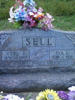
Eva L. Osborn Sell
| Birth | : | 11 Mar 1898 Rochester, Cedar County, Iowa, USA |
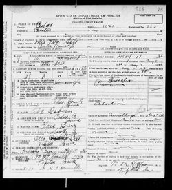
| Death | : | 11 May 1936 Cedar County, Iowa, USA |
| Burial | : | Napier Cemetery, Hohenwald, Lewis County, USA |
| Coordinate | : | 35.4403000, -87.4788971 |
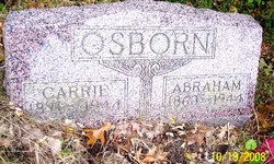
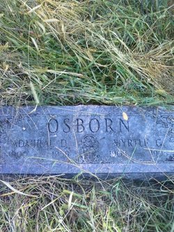
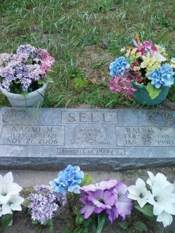
| Description | : | Tipton Advertiser Paper Cedar County, Tipton, Iowa Year 1936 Mrs. Otto Sell, the daughter of Mr. and Mrs. Abe Osborn passed away at her home near Tipton after a short illness of pneumonia, Monday evening at 8:30, May 11, 1936, at the age of 38 years and 2 months. She was born March 11th, 1898 at Rochester. She was married to Otto Sell of Muscatine, November 19,1913. She leaves to mourn, her husband Mr. Otto Sell and three children, one son Ralph, and two daughters, Bernice and Betty Jane all at home, and her father and mother, Mr. and... Read More |
frequently asked questions (FAQ):
-
Where is Eva L. Osborn Sell's memorial?
Eva L. Osborn Sell's memorial is located at: Napier Cemetery, Hohenwald, Lewis County, USA.
-
When did Eva L. Osborn Sell death?
Eva L. Osborn Sell death on 11 May 1936 in Cedar County, Iowa, USA
-
Where are the coordinates of the Eva L. Osborn Sell's memorial?
Latitude: 35.4403000
Longitude: -87.4788971
Family Members:
Parent

Spouse

Siblings
Children

Flowers:


Nearby Cemetories:
1. Napier Cemetery
Hohenwald, Lewis County, USA
Coordinate: 35.4403000, -87.4788971
2. Napier Cemetery
Lewis County, USA
Coordinate: 35.4367000, -87.4783000
3. Newtown Cemetery
Lewis County, USA
Coordinate: 35.4399986, -87.4906006
4. Pollock Cemetery
Lewis County, USA
Coordinate: 35.4672012, -87.5006027
5. Bailey Cemetery
Lewis County, USA
Coordinate: 35.4193993, -87.5152969
6. Collier Cemetery
Lewis County, USA
Coordinate: 35.4606018, -87.5171967
7. Dirtdobber Cemetery
Lewis County, USA
Coordinate: 35.4296989, -87.5327988
8. Laurel Hill Cemetery
Lawrence County, USA
Coordinate: 35.3939018, -87.5156021
9. Pope Cemetery
Lewis County, USA
Coordinate: 35.4646988, -87.5417023
10. Voorhies Cemetery
Lewis County, USA
Coordinate: 35.4413986, -87.5496979
11. Vinson Family Cemetery
Lawrenceburg, Lawrence County, USA
Coordinate: 35.3859000, -87.4542400
12. Davis Cemetery
Lewis County, USA
Coordinate: 35.4564018, -87.5483017
13. Himes Cemetery
Lewis County, USA
Coordinate: 35.4925003, -87.4443970
14. Brock Cemetery
Lawrence County, USA
Coordinate: 35.3892000, -87.4414000
15. Garland Cemetery
Lawrenceburg, Lawrence County, USA
Coordinate: 35.3763657, -87.4737473
16. Poore Cemetery
Lewis County, USA
Coordinate: 35.4874992, -87.5430984
17. Grinders Creek Cemetery
Lewis County, USA
Coordinate: 35.5099983, -87.4963989
18. Pioneer Cemetery
Hohenwald, Lewis County, USA
Coordinate: 35.5107994, -87.4606018
19. Brush Creek Cemetery
Lawrence County, USA
Coordinate: 35.3950005, -87.5531006
20. Grinders Creek Cemetery
Lewis County, USA
Coordinate: 35.4944000, -87.5438995
21. Payton Cemetery
Lewis County, USA
Coordinate: 35.4067001, -87.5653000
22. Henryville Cemetery
Henryville, Lawrence County, USA
Coordinate: 35.3955994, -87.3996964
23. Wright Cemetery
Lewis County, USA
Coordinate: 35.5208015, -87.4803009
24. Freedom Holy Temple Cemetery
Hohenwald, Lewis County, USA
Coordinate: 35.5015340, -87.5482810