
| Birth | : | 1891 |
| Death | : | 1967 |
| Burial | : | Green Cemetery, Glastonbury, Hartford County, USA |
| Coordinate | : | 41.7014008, -72.6053009 |
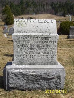
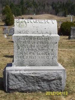
| Description | : | d/o Aaron G and Nellie I (Partridge) Sargent, w/o Harris Joseph Drew whom she married on 21 Jun 1913 in Glover, Orleans County, VT. |
frequently asked questions (FAQ):
-
Where is Fannie Mildred Sargent Drew's memorial?
Fannie Mildred Sargent Drew's memorial is located at: Green Cemetery, Glastonbury, Hartford County, USA.
-
When did Fannie Mildred Sargent Drew death?
Fannie Mildred Sargent Drew death on 1967 in
-
Where are the coordinates of the Fannie Mildred Sargent Drew's memorial?
Latitude: 41.7014008
Longitude: -72.6053009
Family Members:
Parent

Spouse

Siblings
Flowers:


Nearby Cemetories:
1. Green Cemetery
Glastonbury, Hartford County, USA
Coordinate: 41.7014008, -72.6053009
2. Saint James Episcopal Church Memorial Garden
Glastonbury, Hartford County, USA
Coordinate: 41.7146200, -72.6101870
3. Saint James Cemetery
Glastonbury, Hartford County, USA
Coordinate: 41.7158012, -72.6078033
4. Old Church Cemetery
South Glastonbury, Hartford County, USA
Coordinate: 41.6814003, -72.6007996
5. Saint John the Baptist Ukranian Catholic Cemetery
Glastonbury, Hartford County, USA
Coordinate: 41.6960983, -72.5733032
6. Our Saviour Cemetery
Glastonbury, Hartford County, USA
Coordinate: 41.7033005, -72.5725021
7. Saint Michaels Ukrainian Catholic Church Cemetery
Glastonbury, Hartford County, USA
Coordinate: 41.6962013, -72.5724030
8. Wethersfield Village Cemetery
Wethersfield, Hartford County, USA
Coordinate: 41.7116013, -72.6499481
9. Holy Cross Cemetery
Glastonbury, Hartford County, USA
Coordinate: 41.7166710, -72.5606613
10. Saint Augustine Cemetery
Glastonbury, Hartford County, USA
Coordinate: 41.6646996, -72.5952988
11. Trinity Parish Memorial Garden
Wethersfield, Hartford County, USA
Coordinate: 41.7148190, -72.6522590
12. Old South Cemetery
East Hartford, Hartford County, USA
Coordinate: 41.7356453, -72.6341324
13. Old South Cemetery
South Glastonbury, Hartford County, USA
Coordinate: 41.6585999, -72.6042023
14. Wethersfield State Prison Cemetery
Wethersfield, Hartford County, USA
Coordinate: 41.7195360, -72.6603130
15. Hockanum Cemetery
East Hartford, Hartford County, USA
Coordinate: 41.7427864, -72.6344910
16. Center Cemetery
Rocky Hill, Hartford County, USA
Coordinate: 41.6605988, -72.6389008
17. Neipsic Cemetery
Glastonbury, Hartford County, USA
Coordinate: 41.6972008, -72.5374985
18. Saint Andrews Church Memorial Garden
Rocky Hill, Hartford County, USA
Coordinate: 41.6671830, -72.6586290
19. Sgt Herman Baker Jr. Grave Site
East Hartford, Hartford County, USA
Coordinate: 41.7498480, -72.6375890
20. Old Eastbury Cemetery
Glastonbury, Hartford County, USA
Coordinate: 41.7043991, -72.5318985
21. Wassuc Cemetery
Glastonbury, Hartford County, USA
Coordinate: 41.6730995, -72.5389023
22. Rose Hill Memorial Park
Rocky Hill, Hartford County, USA
Coordinate: 41.6547012, -72.6588974
23. Colonel Raymond F. Gates Memorial Cemetery
Rocky Hill, Hartford County, USA
Coordinate: 41.6512718, -72.6548615
24. Buckingham Cemetery
Glastonbury, Hartford County, USA
Coordinate: 41.7120094, -72.5229721