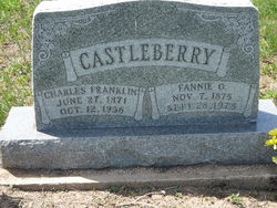
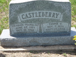
Fannie Osgood Castleberry
| Birth | : | 7 Nov 1875 Lee County, Texas, USA |
| Death | : | 23 Sep 1975 Molalla, Clackamas County, Oregon, USA |
| Burial | : | Danish Cemetery, Fruitdale, Butte County, USA |
| Coordinate | : | 44.6408005, -103.6485977 |
| Description | : | She died in Multnomah, OR. Her obit was in the Rapid City Journal newspaper on October 2, 1975. |
frequently asked questions (FAQ):
-
Where is Fannie Osgood Castleberry's memorial?
Fannie Osgood Castleberry's memorial is located at: Danish Cemetery, Fruitdale, Butte County, USA.
-
When did Fannie Osgood Castleberry death?
Fannie Osgood Castleberry death on 23 Sep 1975 in Molalla, Clackamas County, Oregon, USA
-
Where are the coordinates of the Fannie Osgood Castleberry's memorial?
Latitude: 44.6408005
Longitude: -103.6485977
Family Members:
Parent
Spouse
Siblings
Children
Flowers:
Nearby Cemetories:
1. Danish Cemetery
Fruitdale, Butte County, USA
Coordinate: 44.6408005, -103.6485977
2. Snoma Cemetery
Fruitdale, Butte County, USA
Coordinate: 44.6330986, -103.6844025
3. Nisland Cemetery
Nisland, Butte County, USA
Coordinate: 44.6769010, -103.5580410
4. Minnesela Cemetery
Belle Fourche, Butte County, USA
Coordinate: 44.6549988, -103.8080978
5. Little Dane Cemetery
Saint Onge, Lawrence County, USA
Coordinate: 44.5252500, -103.6705540
6. Gate of Heaven Cemetery
Saint Onge, Lawrence County, USA
Coordinate: 44.5353000, -103.7237000
7. Beals Cemetery
Vale, Butte County, USA
Coordinate: 44.6185989, -103.4366989
8. Riverside Cemetery
Belle Fourche, Butte County, USA
Coordinate: 44.6631012, -103.8636017
9. Pine Slope Cemetery
Belle Fourche, Butte County, USA
Coordinate: 44.6460991, -103.8666992
10. Saint Paul's Catholic Cemetery
Belle Fourche, Butte County, USA
Coordinate: 44.6461000, -103.8667000
11. Anderson Cemetery
Lawrence County, USA
Coordinate: 44.4747009, -103.6896973
12. Hope Cemetery
Newell, Butte County, USA
Coordinate: 44.7042007, -103.4266968
13. Vale Cemetery
Vale, Butte County, USA
Coordinate: 44.6138992, -103.4052963
14. Whitewood Cemetery
Whitewood, Lawrence County, USA
Coordinate: 44.4617820, -103.6330030
15. Wilson Cemetery
Newell, Butte County, USA
Coordinate: 44.6478004, -103.3961029
16. Crook City Cemetery
Crook City, Lawrence County, USA
Coordinate: 44.4432100, -103.6241500
17. Rose Hill Cemetery
Spearfish, Lawrence County, USA
Coordinate: 44.4802180, -103.8509270
18. Saint Aloysius Cemetery
Sturgis, Meade County, USA
Coordinate: 44.4141340, -103.5193420
19. Oak Ridge Cemetery
Deadwood, Lawrence County, USA
Coordinate: 44.3891983, -103.6766968
20. Bear Butte Cemetery
Sturgis, Meade County, USA
Coordinate: 44.4111595, -103.4947968
21. Saint Ambrose Cemetery
Deadwood, Lawrence County, USA
Coordinate: 44.3821983, -103.7266998
22. Fort Meade National Cemetery
Sturgis, Meade County, USA
Coordinate: 44.4021988, -103.4757996
23. Mount Moriah Cemetery
Deadwood, Lawrence County, USA
Coordinate: 44.3760986, -103.7253036
24. Carbonate Cemetery
Maurice, Lawrence County, USA
Coordinate: 44.4000000, -103.8680500

