
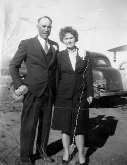

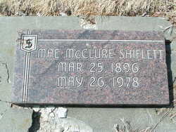
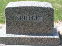
Flora Mae McClure Shiflett
| Birth | : | 25 Mar 1896 Clyde, Haywood County, North Carolina, USA |
| Death | : | 26 May 1978 Wenatchee, Chelan County, Washington, USA |
| Burial | : | Cayucos-Morro Bay District Cemetery, Cayucos, San Luis Obispo County, USA |
| Coordinate | : | 35.4371986, -120.8850021 |
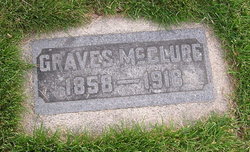
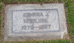
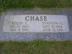
| Description | : | daughter of Philetus Graves McClure and Ermina Jane Terrell m: Charles Beyrle Yocom (1892-1969) Edmond B Yocum - adopted by MR Shiflett - renamed Ned Shiflett Margaret Lee Yocum - adopted by Mr Shiflett - renamed Peggy Shiflett additional information provided by: George Rogers Park Flora Mae Shiflett, 82, Wenatchee Heights, died in a local convalescent center Friday evening. Born March 25, 1896, in Clyde, N. C., she came to the Wenatchee Area with her parents when she was eight years old. She them moved to the Peshastin area where she attended school. She married Sargent D. Shiflett in Coeur d'alene and... Read More |
frequently asked questions (FAQ):
-
Where is Flora Mae McClure Shiflett's memorial?
Flora Mae McClure Shiflett's memorial is located at: Cayucos-Morro Bay District Cemetery, Cayucos, San Luis Obispo County, USA.
-
When did Flora Mae McClure Shiflett death?
Flora Mae McClure Shiflett death on 26 May 1978 in Wenatchee, Chelan County, Washington, USA
-
Where are the coordinates of the Flora Mae McClure Shiflett's memorial?
Latitude: 35.4371986
Longitude: -120.8850021
Family Members:
Parent
Spouse
Children

Flowers:


Nearby Cemetories:
1. St. Peter’s By-the-Sea Episcopal Church Memo
Morro Bay, San Luis Obispo County, USA
Coordinate: 35.3628700, -120.8467400
2. Canet Cemetery
San Luis Obispo County, USA
Coordinate: 35.3522840, -120.7901660
3. Adelaida Cemetery
Adelaida, San Luis Obispo County, USA
Coordinate: 35.5632085, -120.8956170
4. Los Osos Valley Memorial Park
Los Osos, San Luis Obispo County, USA
Coordinate: 35.3053017, -120.8011017
5. Willow Creek Mennonite Cemetery
Wilson Corner, San Luis Obispo County, USA
Coordinate: 35.5890410, -120.8215860
6. Chapel of the Roses Cemetery
Atascadero, San Luis Obispo County, USA
Coordinate: 35.5027340, -120.6881430
7. Atascadero Pine Mountain Cemetery
Atascadero, San Luis Obispo County, USA
Coordinate: 35.4960835, -120.6565582
8. Saint Pauls Episcopal Church Memorial Garden
Cambria, San Luis Obispo County, USA
Coordinate: 35.5575200, -121.0757200
9. Templeton Cemetery
Templeton, San Luis Obispo County, USA
Coordinate: 35.5714455, -120.7022095
10. Dove Cemetery
San Luis Obispo County, USA
Coordinate: 35.4482231, -120.6344299
11. Santa Rosa Cemetery
Cambria, San Luis Obispo County, USA
Coordinate: 35.5662900, -121.0809300
12. Cambria Cemetery
Cambria, San Luis Obispo County, USA
Coordinate: 35.5746994, -121.0922012
13. Adelaida Cemetery
San Luis Obispo County, USA
Coordinate: 35.6563988, -120.8728027
14. Porte Family Cemetery
San Simeon, San Luis Obispo County, USA
Coordinate: 35.6376400, -121.0379800
15. Mission San Luis Obispo Cemetery
San Luis Obispo, San Luis Obispo County, USA
Coordinate: 35.2806600, -120.6645200
16. Old Mission Cemetery
San Luis Obispo, San Luis Obispo County, USA
Coordinate: 35.2670660, -120.6692150
17. San Luis Cemetery
San Luis Obispo, San Luis Obispo County, USA
Coordinate: 35.2644192, -120.6712830
18. Santa Margarita Cemetery
Santa Margarita, San Luis Obispo County, USA
Coordinate: 35.3913994, -120.5880966
19. Saint James Episcopal Church Inurnment Garden
Paso Robles, San Luis Obispo County, USA
Coordinate: 35.6283460, -120.6929780
20. Paso Robles District Cemetery
Paso Robles, San Luis Obispo County, USA
Coordinate: 35.6424700, -120.7035000
21. San Marcos Mennonite Cemetery
San Luis Obispo County, USA
Coordinate: 35.6874570, -120.7995160
22. Creston Cemetery
Creston, San Luis Obispo County, USA
Coordinate: 35.5328640, -120.5121450
23. Estrella Adobe Cemetery
Paso Robles, San Luis Obispo County, USA
Coordinate: 35.6975080, -120.6399460
24. San Miguel District Cemetery
San Miguel, San Luis Obispo County, USA
Coordinate: 35.7392006, -120.7013550