

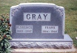
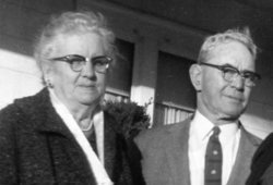
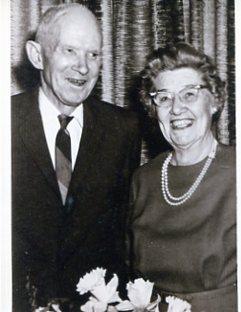
Florence Irene Ships Gray
| Birth | : | 9 Feb 1889 Maryville, Nodaway County, Missouri, USA |
| Death | : | 21 Feb 1987 Maryville, Nodaway County, Missouri, USA |
| Burial | : | Saint Olaf Churchyard Cemetery, Bode, Humboldt County, USA |
| Coordinate | : | 42.8653600, -94.2858300 |
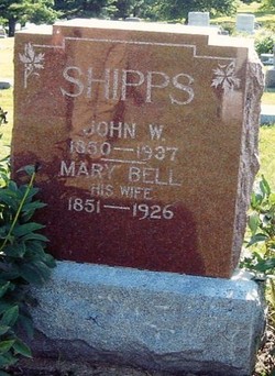
| Description | : | florence was the daughter of john wesley shipps and mary bell heisler shipps. she married james franklin gray nov.9, 1914.they had one son, curtis dean gray. In 1913, and before they were married, Florence and her sister Maye Shipps Corrough were fortunate to belong to the Missouri Ladies Military Band. they went with their band to washington D.C. and marched in a parade for Women's Sufferage down Pennsylvania Ave. Florence play a bass horn and her sister Maye played the slide trombone. They told of this trip many time during their long lives. |
frequently asked questions (FAQ):
-
Where is Florence Irene Ships Gray's memorial?
Florence Irene Ships Gray's memorial is located at: Saint Olaf Churchyard Cemetery, Bode, Humboldt County, USA.
-
When did Florence Irene Ships Gray death?
Florence Irene Ships Gray death on 21 Feb 1987 in Maryville, Nodaway County, Missouri, USA
-
Where are the coordinates of the Florence Irene Ships Gray's memorial?
Latitude: 42.8653600
Longitude: -94.2858300
Family Members:
Parent

Spouse
Siblings

Flowers:


Nearby Cemetories:
1. Saint Olaf Churchyard Cemetery
Bode, Humboldt County, USA
Coordinate: 42.8653600, -94.2858300
2. Saint Olaf Lutheran Cemetery
Bode, Humboldt County, USA
Coordinate: 42.8628000, -94.2773000
3. Union Cemetery
Livermore, Humboldt County, USA
Coordinate: 42.8778000, -94.2177963
4. Saint Joseph Catholic Cemetery
Saint Joseph, Kossuth County, USA
Coordinate: 42.9119137, -94.2296852
5. Union Cemetery
Ottosen, Humboldt County, USA
Coordinate: 42.8879128, -94.3792496
6. Mount Calvary Cemetery
Livermore, Humboldt County, USA
Coordinate: 42.8488998, -94.1802979
7. McKnight Cemetery
Bode, Humboldt County, USA
Coordinate: 42.8635100, -94.4055600
8. Omer-Thorsen Farm Cemetery
Ottosen, Humboldt County, USA
Coordinate: 42.8735742, -94.4085743
9. Rutland Township Cemetery
Rutland, Humboldt County, USA
Coordinate: 42.7574997, -94.2652969
10. Union Cemetery
Humboldt, Humboldt County, USA
Coordinate: 42.7407990, -94.2375031
11. Apostolic V Christian Cemetery
Kossuth County, USA
Coordinate: 42.9630870, -94.4238290
12. Old Rolfe Cemetery
Rolfe, Pocahontas County, USA
Coordinate: 42.8403511, -94.4764175
13. Laurel Hill Cemetery
Irvington, Kossuth County, USA
Coordinate: 43.0017014, -94.1939011
14. West Bend Cemetery
West Bend, Palo Alto County, USA
Coordinate: 42.9590000, -94.4548000
15. Garfield Township Cemetery
Kossuth County, USA
Coordinate: 42.9947000, -94.4080000
16. Mount Hope Cemetery
Unique, Humboldt County, USA
Coordinate: 42.7169250, -94.3740570
17. Saint Marys Cemetery
Humboldt, Humboldt County, USA
Coordinate: 42.7131004, -94.2067032
18. Lu Verne Cemetery
Lu Verne, Kossuth County, USA
Coordinate: 42.9152000, -94.0733000
19. Marble Valley Cemetery
Gilmore City, Humboldt County, USA
Coordinate: 42.7458850, -94.4430150
20. Clinton-Garfield Cemetery
Rolfe, Pocahontas County, USA
Coordinate: 42.8055300, -94.5202500
21. Saint Margarets Cemetery
Rolfe, Pocahontas County, USA
Coordinate: 42.8164978, -94.5307465
22. Indian Mound Cemetery
Humboldt, Humboldt County, USA
Coordinate: 42.6880989, -94.2074966
23. Riverside Cemetery
West Bend, Palo Alto County, USA
Coordinate: 42.9512000, -94.5120000
24. Saint Johns Catholic Cemetery
Gilmore City, Pocahontas County, USA
Coordinate: 42.7332993, -94.4672012