

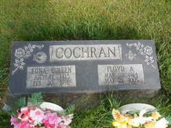
Floyd A. Cochran
| Birth | : | 21 Mar 1914 Arkansas City, Cowley County, Kansas, USA |
| Death | : | 21 May 2005 Farmington, San Juan County, New Mexico, USA |
| Burial | : | Calvary Cemetery, Omaha, Douglas County, USA |
| Coordinate | : | 41.2364006, -96.0294037 |
| Plot | : | Block 8 |
| Description | : | Floyd A. Cochran, 91, passed away Saturday, May 21, 2005, in Farmington. Floyd was born in Arkansas City, Kan., on March 21, 1914, to George and Merle Cochran. He graduated from Grand Junction High School in 1933 and married his high school sweetheart, Euleen Winn on Nov. 1, 1934. Floyd moved his family to Durango in the early 1940s and owned and operated Mesa Verde Outdoor Advertising for more than 30 years. He was active in all orders of the Masonic Lodge, Presbyterian Church, Independent Order of Oddfellows and the Rose Society. Floyd took pride in raising beautiful roses. While... Read More |
frequently asked questions (FAQ):
-
Where is Floyd A. Cochran's memorial?
Floyd A. Cochran's memorial is located at: Calvary Cemetery, Omaha, Douglas County, USA.
-
When did Floyd A. Cochran death?
Floyd A. Cochran death on 21 May 2005 in Farmington, San Juan County, New Mexico, USA
-
Where are the coordinates of the Floyd A. Cochran's memorial?
Latitude: 41.2364006
Longitude: -96.0294037
Family Members:
Parent

Spouse
Siblings
Children
Flowers:


Nearby Cemetories:
1. Calvary Cemetery
Omaha, Douglas County, USA
Coordinate: 41.2364006, -96.0294037
2. Evergreen Memorial Park Cemetery
Omaha, Douglas County, USA
Coordinate: 41.2393990, -96.0355988
3. Resurrection Cemetery
Omaha, Douglas County, USA
Coordinate: 41.2344208, -96.0365448
4. Ak-Sar-Ben Racetrack Grounds
Omaha, Douglas County, USA
Coordinate: 41.2414703, -96.0159607
5. Saint Andrews Episcopal Church Columbarium
Omaha, Douglas County, USA
Coordinate: 41.2492500, -96.0427500
6. Countryside Community Church Columbarium
Omaha, Douglas County, USA
Coordinate: 41.2483660, -96.0500270
7. Westlawn-Hillcrest Memorial Park
Omaha, Douglas County, USA
Coordinate: 41.2346992, -95.9966965
8. Bohemian Cemetery
Omaha, Douglas County, USA
Coordinate: 41.2388992, -95.9955978
9. Beth El Cemetery
Ralston, Douglas County, USA
Coordinate: 41.2117004, -96.0428009
10. Holy Sepulchre Cemetery
Omaha, Douglas County, USA
Coordinate: 41.2543983, -95.9875031
11. Douglas County Poor Farm Cemetery
Omaha, Douglas County, USA
Coordinate: 41.2437240, -95.9723480
12. Graceland Park Cemetery
Omaha, Douglas County, USA
Coordinate: 41.2113991, -95.9785995
13. Saint Mary Magdalene Cemetery
Omaha, Douglas County, USA
Coordinate: 41.2039420, -95.9850610
14. All Saints Episcopal Church Columbarium
Omaha, Douglas County, USA
Coordinate: 41.2785000, -96.0579000
15. First Central Congregational Columbarium
Omaha, Douglas County, USA
Coordinate: 41.2563456, -95.9658365
16. Nash Chapel Crypt
Omaha, Douglas County, USA
Coordinate: 41.2665090, -95.9721790
17. Saint Mary's Cemetery
Omaha, Douglas County, USA
Coordinate: 41.2042007, -95.9646988
18. Papillion Cemetery
Papillion, Sarpy County, USA
Coordinate: 41.1758003, -96.0410995
19. Portal Cemetery
Sarpy County, USA
Coordinate: 41.1838989, -96.0802994
20. Servants of Mary Cemetery
Omaha, Douglas County, USA
Coordinate: 41.3017170, -96.0258260
21. Prospect Hill Cemetery
Omaha, Douglas County, USA
Coordinate: 41.2780991, -95.9593964
22. Mount Hope Cemetery
Omaha, Douglas County, USA
Coordinate: 41.3041992, -96.0310974
23. Saint Johns Cemetery
Bellevue, Sarpy County, USA
Coordinate: 41.1864014, -95.9682999
24. Pleasant Hill Cemetery
Omaha, Douglas County, USA
Coordinate: 41.2558975, -96.1194687