
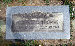
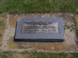
Forrest G. Thomas
| Birth | : | 27 Apr 1891 Ellensburg, Kittitas County, Washington, USA |
| Death | : | 30 Jul 1973 Moses Lake, Grant County, Washington, USA |
| Burial | : | Hope Lutheran Cemetery, Delmont, Douglas County, USA |
| Coordinate | : | 43.2821999, -98.1568985 |
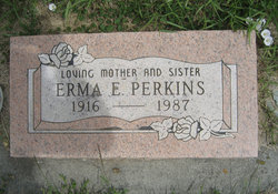
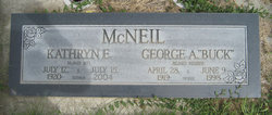
| Description | : | OBIT: Forrest G. Thomas, 82, died July 30 at Samaritan Hospital. He was born April 27, 1891 in Ellensburg and spent his childhood in the area. On April 25, 1913 he married Kate Hatfield and the couple farmed near Ellensburg. Thomas was also a ditchrider for the USBR. Mrs. Thomas died July 15, 1961. The couple moved here in 1951 and Thomas was a member of the First Baptist Church. Survivors include two daughters, Mrs. Erma Perkins and Mrs. George McNeil of Moses Lake; three brothers, George of Ellensburg, Gus of Moses Lake and Orval of Granger; a sister,... Read More |
frequently asked questions (FAQ):
-
Where is Forrest G. Thomas's memorial?
Forrest G. Thomas's memorial is located at: Hope Lutheran Cemetery, Delmont, Douglas County, USA.
-
When did Forrest G. Thomas death?
Forrest G. Thomas death on 30 Jul 1973 in Moses Lake, Grant County, Washington, USA
-
Where are the coordinates of the Forrest G. Thomas's memorial?
Latitude: 43.2821999
Longitude: -98.1568985
Family Members:
Spouse
Children
Flowers:


Nearby Cemetories:
1. Hope Lutheran Cemetery
Delmont, Douglas County, USA
Coordinate: 43.2821999, -98.1568985
2. Zion Lutheran Cemetery
Delmont, Douglas County, USA
Coordinate: 43.2822000, -98.1558000
3. Delmont Cemetery
Delmont, Douglas County, USA
Coordinate: 43.2757988, -98.1481018
4. Old Missouri Cemetery
Delmont, Douglas County, USA
Coordinate: 43.2947006, -98.2043991
5. Emmanuel Lutheran Cemetery
Delmont, Douglas County, USA
Coordinate: 43.3331200, -98.1885800
6. Neusatz Cemetery
Douglas County, USA
Coordinate: 43.3410988, -98.1643982
7. Hoffnungsberg Cemetery
Hutchinson County, USA
Coordinate: 43.2972600, -98.0485700
8. Saint Marys Cemetery
Douglas County, USA
Coordinate: 43.3703000, -98.1119000
9. Oak Hollow Cemetery
Hutchinson County, USA
Coordinate: 43.1963997, -98.0599976
10. Zion Baptist Church Cemetery
Wagner, Charles Mix County, USA
Coordinate: 43.1761400, -98.2085800
11. Congregational Church Cemetery
Charles Mix County, USA
Coordinate: 43.1695600, -98.1834300
12. Haffner Family Farm Cemetery
Hutchinson County, USA
Coordinate: 43.2134840, -98.0312720
13. Eigenfeld Evangelical Lutheran Cemetery
Hutchinson County, USA
Coordinate: 43.3549995, -98.0335999
14. New Salem Reformed Cemetery
Charles Mix County, USA
Coordinate: 43.1683006, -98.1271973
15. Saint Pauls Lutheran Cemetery
Charles Mix County, USA
Coordinate: 43.1642780, -98.1687250
16. Saint Peters Cemetery
Douglas County, USA
Coordinate: 43.3847008, -98.2514038
17. Evangelic Cemetery
Douglas County, USA
Coordinate: 43.4124985, -98.1318970
18. Zion Cemetery
Parkston, Hutchinson County, USA
Coordinate: 43.3448100, -97.9939900
19. Pleasant Ridge Cemetery
Armour, Douglas County, USA
Coordinate: 43.3250008, -98.3386002
20. Roberts Chapel Cemetery
Douglas County, USA
Coordinate: 43.4127998, -98.2225037
21. Pietz Cemetery
Hutchinson County, USA
Coordinate: 43.2703018, -97.9599991
22. Zion Lutheran Cemetery
Tripp, Hutchinson County, USA
Coordinate: 43.1974400, -97.9917300
23. Friedens Reformed Cemetery
Tripp, Hutchinson County, USA
Coordinate: 43.2113991, -97.9657974
24. Grace Hill Cemetery
Tripp, Hutchinson County, USA
Coordinate: 43.2111015, -97.9638977